ファイル:Provincetown before after railroad.png

元のファイル (2,230 × 2,460 ピクセル、ファイルサイズ: 9.88メガバイト、MIME タイプ: image/png)
ウィキメディア・コモンズのファイルページにある説明を、以下に表示します。
|
| 解説 |
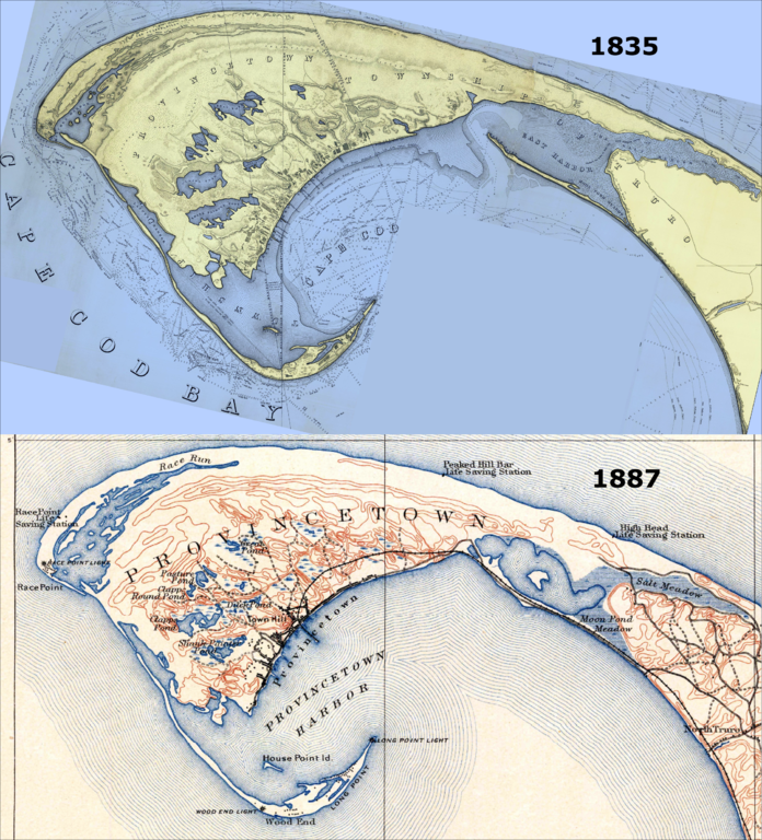
Town of Provincetown, before and after the railroad. Most notably, there were no roads in/out of town until the US government artificially sealed off the Eastern Harbor. This was done so as to prevent storm washout from breaching the northernmost part of that harbor; a breach would have made Provincetown an island permanently, and would have destroyed the valuable harbor. This later provided the foundation for the railroad to finally come to Provincetown in 1873, and for a formal road in 1877. Top (1835) map extracted from "A Map Of The Extremity Of Cape Cod Including the Townships of Provincetown & Truro: A Chart Of Their Sea Coast And Of Cape Cod Harbour, State of Massachusetts", by the U.S. Topographical Engineers (later were rolled into the US Army Corps of Engineers. Grolltech: Colorized and reoriented with north to top of page. Bottom (1887) map extracted from "Massachusetts, Provincetown Sheet", by the US Geological Survey. See individual file pages for more details about the original works. |
|||||||||
| 日付 | (top) and 1887 (bottom) | |||||||||
| 原典 | United States Topographical Bureau (top), US Geological Survey (bottom) | |||||||||
| 作者 |
Top: Graham, Maj. James D., Hood, Washington, U.S. Topo. Engrs., United States Topographical Bureau Bottom: Henry Gannett and Marcus Baker, US Geological Survey (USGS) |
|||||||||
| 許可 (ファイルの再利用) |
|
|||||||||
| その他のバージョン | ||||||||||


ファイルの履歴
過去の版のファイルを表示するには、その版の日時をクリックしてください。
| 日付と時刻 | サムネイル | 寸法 | 利用者 | コメント | |
|---|---|---|---|---|---|
| 現在の版 | 2012年6月7日 (木) 22:52 | | 2,230 × 2,460 (9.88メガバイト) | Grolltech | {{Information |Description=Town of Provincetown, before and after the railroad. Most notably, there were no roads in/out of town until the US government artificially sealed off the Eastern Harbor. This was done so as to prevent storm washout from brea... |
ファイルの使用状況
以下のページがこのファイルを使用しています:
グローバルなファイル使用状況
以下に挙げる他のウィキがこの画像を使っています:
- en.wikipedia.org での使用状況
- vi.wikipedia.org での使用状況
- www.wikidata.org での使用状況