ファイル:Sarajevo Grbavica.JPG
元のファイル (2,900 × 1,860 ピクセル、ファイルサイズ: 3.9メガバイト、MIME タイプ: image/jpeg)
ウィキメディア・コモンズのファイルページにある説明を、以下に表示します。
|
概要
| 解説 |
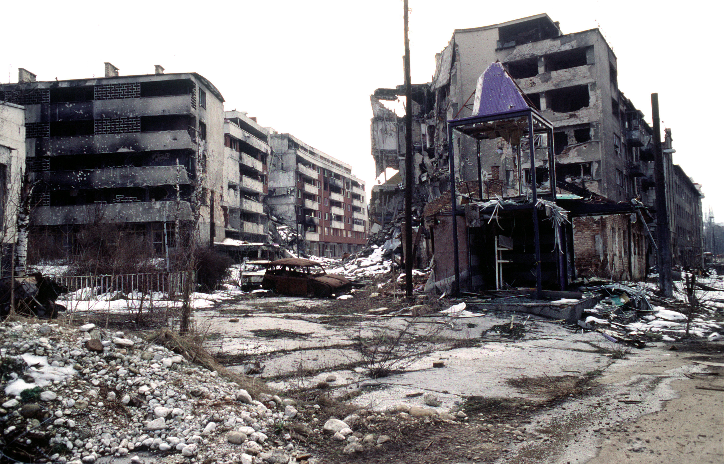
View of Grbavica, a neighbourhood of Sarajevo, approximately 4 months after the signing of the Dayton Peace Accord that officially ended the war in Bosnia. This particular scene shows the part of the neighbourhood located by the left bank of Miljacka river near Vrbanja bridge at the point where Zagrebačka Street and Beogradska Street (later renamed Emerika Bluma Street) meet. Throughout the war (1992-1995), Grbavica was held by the forces of Bosnian Serbs. In relation to the part of Grbavica shown in the photo, Bosnian Muslim (Bosniak) lines were right across on the Miljacka river's right bank. Due to its location in the crossfire between two sides, this part of Grbavica was exposed to constant fire and as a result suffered heavy structural damage. It was basically uninhabitable throughout the war - most of the apartments in the buildings seen in the photo were empty during the war as their occupants fled early on fearing for their safety. These ruins of the apartments and houses were among the last group to be turned over by the Bosnian Serbs to the Bosniaks (a.k.a. Bosnian Muslims) as required by the Dayton Peace Accord, which produced a lasting cease fire and permanent internal borders between two entities - Republika Srpska (Serb entity) and Federation of Bosnia-Herzegovina (Muslim-Croat entity). The white building whose small part (corner) can be seen along the photo's left edge housed the state-owned Unioninvest company before the war. In the years after the war ended, the partially devastated building was rebuilt and to this day houses the Office of the High Representative (OHR), an ad hoc international institution responsible for overseeing implementation of the Dayton Peace Accord (in essence, OHR is Bosnia's highest decision-making institutional body with broad powers). |
| 日付 | |
| 原典 | www.dodmedia.osd.mil |
| 作者 | LT. STACEY WYZKOWSKI |
| 許可 (ファイルの再利用) |
Public Domain (PD-USGov-Military) |
| カメラの位置 | | 以下のサービスでこの位置を確認する: オープンストリートマップ |
|---|
ライセンス
この画像はアメリカ軍又はアメリカ国防総省の職員がその公務の一環として撮影又は作成した著作物です。アメリカ合衆国連邦政府の著作物として、この画像はアメリカ合衆国においてパブリックドメインの状態にあります。
|
 |
ファイルの履歴
過去の版のファイルを表示するには、その版の日時をクリックしてください。
| 日付と時刻 | サムネイル | 寸法 | 利用者 | コメント | |
|---|---|---|---|---|---|
| 現在の版 | 2009年4月7日 (火) 21:02 | | 2,900 × 1,860 (3.9メガバイト) | PRODUCER | contrast |
| 2008年3月23日 (日) 14:37 |  | 2,900 × 1,860 (2.14メガバイト) | ¡0-8-15! | ||
| 2006年11月20日 (月) 22:00 |  | 640 × 410 (60キロバイト) | Bunker~commonswiki | == Summary == {{Information |Description=Overall view of downtown Grbavica, a suburb of Sarajevo. These apartments and houses once occupied by Bosnia Serbs are the last group to be turned over to the Muslims as required by the recent Dayton Peace Accord w |
ファイルの使用状況
以下のページがこのファイルを使用しています:
グローバルなファイル使用状況
以下に挙げる他のウィキがこの画像を使っています:
- als.wikipedia.org での使用状況
- ar.wikipedia.org での使用状況
- azb.wikipedia.org での使用状況
- be.wikipedia.org での使用状況
- bg.wikipedia.org での使用状況
- bs.wikipedia.org での使用状況
- ca.wikipedia.org での使用状況
- cs.wikipedia.org での使用状況
- de.wikipedia.org での使用状況
- el.wikipedia.org での使用状況
- en.wikipedia.org での使用状況
- en.wikinews.org での使用状況
- en.wikiquote.org での使用状況
- eo.wikipedia.org での使用状況
- es.wikipedia.org での使用状況
- eu.wikipedia.org での使用状況
- fa.wikipedia.org での使用状況
- fr.wikipedia.org での使用状況
- he.wikipedia.org での使用状況
- hr.wikipedia.org での使用状況
- hu.wikipedia.org での使用状況
- id.wikipedia.org での使用状況
- it.wikipedia.org での使用状況
このファイルのグローバル使用状況を表示する。