ファイル:Sedan Plowshare Crater.jpg
このプレビューのサイズ: 755 × 599 ピクセル。 その他の解像度: 302 × 240 ピクセル | 605 × 480 ピクセル | 968 × 768 ピクセル | 1,280 × 1,016 ピクセル | 1,426 × 1,132 ピクセル。
元のファイル (1,426 × 1,132 ピクセル、ファイルサイズ: 202キロバイト、MIME タイプ: image/jpeg)
ウィキメディア・コモンズのファイルページにある説明を、以下に表示します。
|
| 解説 |
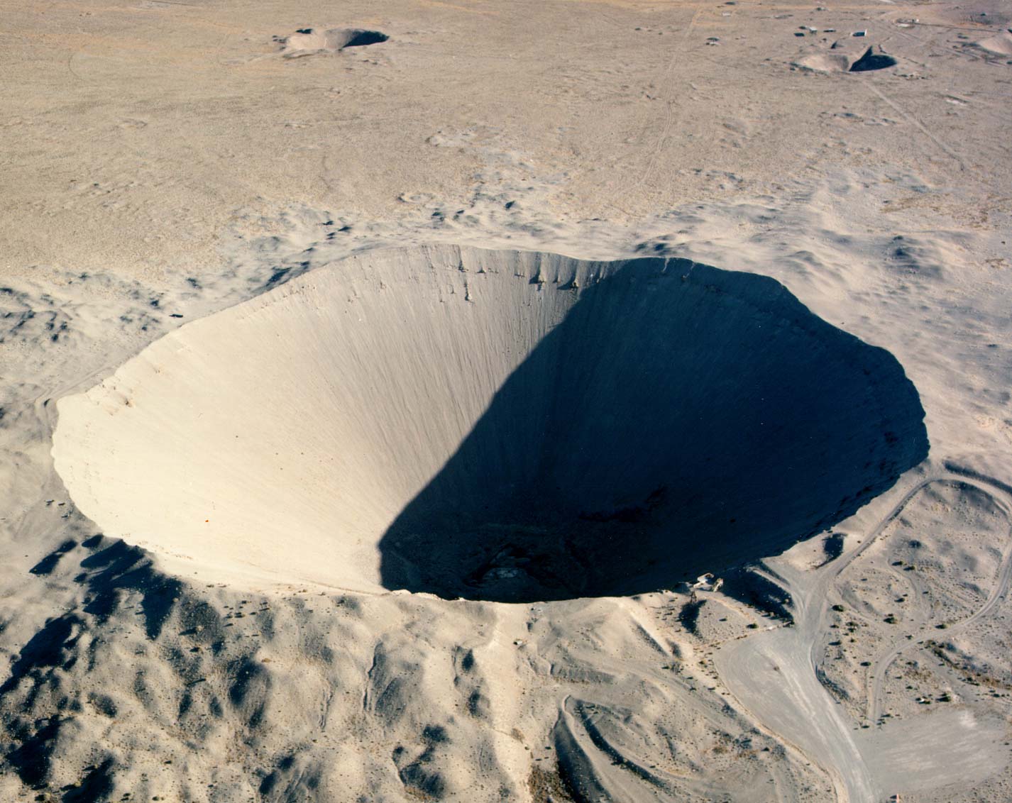
English: Crater from the 1962 "Sedan" nuclear test as part of Operation Plowshare. The 104 kiloton blast displaced 12 million tons of earth and created a crater 320 feet deep and 1,280 feet wide. (Look to the size of the roads in the bottom-right of the picture, and the observation deck at the lower-right edge of the crater, for a sense of scale) العربية: فوهة بركان سيدان هي نتيجة اختبار سيدان النووي ويقع داخل موقع اختبار نيفادا، على بعد 12 ميلاً (19 كم) جنوب غرب بحيرة جرووم |
|
| 原典 |
|
|
| 作者 | Federal Government of the United States |
| カメラの位置 | | 以下のサービスでこの位置を確認する: オープンストリートマップ |
|---|
この画像は2006年1月27日の今日の一枚に選ばれました。その際の説明文は以下のとおりでした。 他の言語
Čeština: Kráter po zkušebním jaderném výbuchu v Nevadě. Cymraeg: Crater oddiwrth brawf niwcliar yn y Seit Profi Nevada. Dansk: Krater fra en kernevåben-test i testområdet i Nevada, USA. Deutsch: Krater von einem Nukleartest auf dem Nevadatestgelände English: Crater from a nuclear test at Nevada Test Site. Italiano: Cratere provocato da un test nucleare nel Nevada Test Site. Magyar: Egy nukleáris robbantás krátere. Nevada, USA. Nederlands: Krater als gevolg van een nucleaire test op de testvlakte in Nevada. Polski: Krater w strefie testów nuklearnych w stanie Nevada Slovenščina: Krater jedrskega preizkusa na preizkuševalnem območju Nevada. ગુજરાતી : નેવાડાના ન્યુક્લિયર પરિક્ષણ મથક પર ભૂગર્ભ પરિક્ષણ બાદ રહેલો ખાડો. 한국어: 네바다 핵실험 장소에 있는 폭탄 구멍. العربية : حفرة هائلة جراء انفجار نووي في منطقة الاختبارات النووية بولاية نيفادا الأمريكية |
このファイルは、アメリカ合衆国の連邦政府と雇用関係にある公務員がその職務上作成したアメリカ合衆国政府の著作物であり、アメリカ合衆国の著作権法上パブリックドメインに属します (17 U.S.C. §105)。
注意:このライセンスは、アメリカ合衆国政府の著作物についてのみ効力を有します。アメリカ合衆国の各州、郡、その他の地方自治体が作成した著作物に対しては適用できません。
|
 | |
| このファイルは著作権法の既知の制約(隣接権や関連する権利を含む)から自由であると特定されています。 | ||
ファイルの履歴
過去の版のファイルを表示するには、その版の日時をクリックしてください。
| 日付と時刻 | サムネイル | 寸法 | 利用者 | コメント | |
|---|---|---|---|---|---|
| 現在の版 | 2005年12月11日 (日) 17:49 | | 1,426 × 1,132 (202キロバイト) | Fastfission~commonswiki | even higher res |
| 2005年5月22日 (日) 20:30 |  | 685 × 543 (338キロバイト) | Xenoforme~commonswiki |
ファイルの使用状況
グローバルなファイル使用状況
以下に挙げる他のウィキがこの画像を使っています:
- af.wikipedia.org での使用状況
- ar.wikipedia.org での使用状況
- beta.wikiversity.org での使用状況
- bg.wikipedia.org での使用状況
- ca.wikipedia.org での使用状況
- ceb.wikipedia.org での使用状況
- cs.wikipedia.org での使用状況
- de.wikipedia.org での使用状況
- de.wiktionary.org での使用状況
- en.wikipedia.org での使用状況
- Nuclear explosive
- Nevada Test Site
- Project Plowshare
- Nuclear weapons testing
- Sedan (nuclear test)
- Wikipedia:Recent additions 26
- Peaceful nuclear explosion
- Underground nuclear weapons testing
- Craterization
- Yucca Flat
- Explosion crater
- Wikipedia:Did you know/Statistics/Monthly DYK pageview leaders/2008
- Wikipedia:Recent additions/2005/March
- User:Binksternet/DYK
- Wikipedia:Recent additions/2008/July
- July 1962
- National Register of Historic Places listings in Nye County, Nevada
- User:Boundarylayer/sandbox
- User:Epicgenius/Userpage/Rest of year
- Crater
- User:Ikluft/essay/Categorization of craters
- History of the Petroleum industry in Alberta
- en.wikibooks.org での使用状況
このファイルのグローバル使用状況を表示する。