ファイル:TalladegaSuperspeedway2.jpg

このプレビューのサイズ: 800 × 600 ピクセル。 その他の解像度: 320 × 240 ピクセル | 640 × 480 ピクセル | 1,024 × 768 ピクセル | 1,280 × 960 ピクセル | 2,576 × 1,932 ピクセル。
元のファイル (2,576 × 1,932 ピクセル、ファイルサイズ: 804キロバイト、MIME タイプ: image/jpeg)
ウィキメディア・コモンズのファイルページにある説明を、以下に表示します。
|
概要
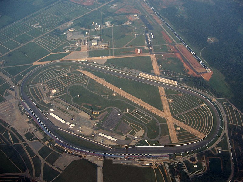
| 解説 | This image is of the Talladega Superspeedway, located in Talladega, Alabama. The image was taken from approximately 5000ft MSL (4500ft AGL) with visibility limited to approximately 4sm due to haze. The left wheel of the aircraft has been digitally removed from the image, causing some distortion in the lower sections, just below the track. The old w:Talladega Municipal Airport runways are still visible, crossing inside the track. The new airport and runway are located in the background, just north east of the track's position. |
| 日付 | |
| 原典 | 投稿者自身による著作物 |
| 作者 | AuburnPilot |
| カメラの位置 | | 以下のサービスでこの位置を確認する: オープンストリートマップ |
|---|
ライセンス
| この著作物の著作権者である私は、この著作物における権利を放棄しパブリックドメインとします。これは全世界で適用されます。 一部の国では、これが法的に可能ではない場合があります。その場合は、次のように宣言します。 私は、あらゆる人に対して、法により必要とされている条件を除き、如何なる条件も課すことなく、あらゆる目的のためにこの著作物を使用する権利を与えます。 |
ファイルの履歴
過去の版のファイルを表示するには、その版の日時をクリックしてください。
| 日付と時刻 | サムネイル | 寸法 | 利用者 | コメント | |
|---|---|---|---|---|---|
| 現在の版 | 2007年9月9日 (日) 04:51 | | 2,576 × 1,932 (804キロバイト) | AuburnPilot | {{Information |Description=This image is of the Talladega Superspeedway, located in Talladega, Alabama. The image was taken from approximately 5000ft MSL (4500ft AGL) with visibility limited to approx |
ファイルの使用状況
以下のページがこのファイルを使用しています:
グローバルなファイル使用状況
以下に挙げる他のウィキがこの画像を使っています:
- ast.wikipedia.org での使用状況
- ca.wikipedia.org での使用状況
- cs.wikipedia.org での使用状況
- de.wikipedia.org での使用状況
- en.wikipedia.org での使用状況
- Talladega, Alabama
- Talladega Superspeedway
- 2007 UAW-Ford 500
- 2008 AMP Energy 500
- 2009 Aaron's 499
- 2010 AMP Energy Juice 500
- 2011 Aaron's 499
- 2012 Aaron's 499
- 2012 Good Sam Roadside Assistance 500
- 2013 Aaron's 499
- 2013 Camping World RV Sales 500
- User:AuburnPilot/Images
- 2014 Aaron's 499
- 2006 UAW-Ford 500
- 2015 GEICO 500
- 2015 CampingWorld.com 500 at Talladega
- 2016 GEICO 500
- 2016 Hellmann's 500
- 2017 GEICO 500
- 2017 Alabama 500
- 2018 GEICO 500
- 2018 1000Bulbs.com 500
- 2019 GEICO 500
- 2019 MoneyLion 300
- 2019 Sugarlands Shine 250
- 2019 1000Bulbs.com 500
- 2020 GEICO 500
- 2020 YellaWood 500
- 2021 GEICO 500
- 2021 YellaWood 500
- 2012 Aaron's 312
- 2022 YellaWood 500
- 2023 GEICO 500
- 2013 Fred's 250
- 2010 Aaron's 312
- 2023 YellaWood 500
- 2008 Aaron's 312
- 2007 Aaron's 312
- 2009 Aaron's 312
- 2011 Aaron's 312
- 2024 GEICO 500
- 2024 Ag-Pro 300
- 2024 General Tire 200 (Talladega)
- es.wikipedia.org での使用状況
このファイルのグローバル使用状況を表示する。