ファイル:Tannenberg3008.jpg
このプレビューのサイズ: 775 × 600 ピクセル。 その他の解像度: 310 × 240 ピクセル | 620 × 480 ピクセル | 993 × 768 ピクセル | 1,242 × 961 ピクセル。
元のファイル (1,242 × 961 ピクセル、ファイルサイズ: 207キロバイト、MIME タイプ: image/jpeg)
ウィキメディア・コモンズのファイルページにある説明を、以下に表示します。
|

|
このファイルのベクター画像 (SVG) が利用できます。 使う目的に対し、元画像よりもSVGがより優れている場合、SVG画像を使用して下さい。
File:Tannenberg3008.jpg → File:East Prussian Campaign (27—30 Aug 1914) - ru.svg
|
_-_ru.svg) |
| 解説 |
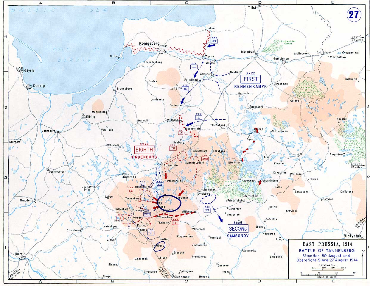
English: Battle of Tannenberg (1914) in its last phase |
| 原典 |
Taken from the campaign series, made public by the US-Army under dean.usma.edu
|
| 作者 | US-Army under www.dean.usma.edu |
| 許可 (ファイルの再利用) |
The picture is public domain. |
|
|
 |
ファイルの履歴
過去の版のファイルを表示するには、その版の日時をクリックしてください。
| 日付と時刻 | サムネイル | 寸法 | 利用者 | コメント | |
|---|---|---|---|---|---|
| 現在の版 | 2005年9月22日 (木) 14:29 | | 1,242 × 961 (207キロバイト) | Nasiruddin | Taken from the campaign series, made public by the US-Army under www.dean.usma.edu The öpicture is public domain. It shows the battle of Tannenberg in its last phase {{PD-USGov-Military-Army}} Category:World War I maps |
ファイルの使用状況
以下のページがこのファイルを使用しています:
グローバルなファイル使用状況
以下に挙げる他のウィキがこの画像を使っています:
- be-tarask.wikipedia.org での使用状況
- be.wikipedia.org での使用状況
- ca.wikipedia.org での使用状況
- cs.wikipedia.org での使用状況
- da.wikipedia.org での使用状況
- de.wikipedia.org での使用状況
- el.wikipedia.org での使用状況
- en.wikipedia.org での使用状況
- et.wikipedia.org での使用状況
- fi.wikipedia.org での使用状況
- fr.wikipedia.org での使用状況
- he.wikipedia.org での使用状況
- hr.wikipedia.org での使用状況
- it.wikipedia.org での使用状況
- ko.wikipedia.org での使用状況
- lv.wikipedia.org での使用状況
- nl.wikipedia.org での使用状況
- no.wikipedia.org での使用状況
- pl.wikipedia.org での使用状況
- sv.wikipedia.org での使用状況
- uk.wikipedia.org での使用状況
- vi.wikipedia.org での使用状況
- zh.wikipedia.org での使用状況