ファイル:Temburong mukims.png
高解像度版はありません。
Temburong_mukims.png (696 × 565 ピクセル、ファイルサイズ: 57キロバイト、MIME タイプ: image/png)
ウィキメディア・コモンズのファイルページにある説明を、以下に表示します。
|
概要
| 解説 |
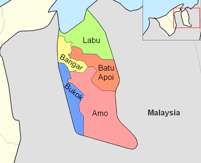
English: Map of the mukims (subdivisions) of the Temburong District of Brunei, in the northwest of the island of Borneo.
Created by Rarelibra 21:37, 11 September 2006 (UTC) for public domain use, using MapInfo Professional v8.5 and various mapping resources. |
| 日付 | 2006年9月11日 (当初のアップロード日) |
| 原典 | en.wikipedia からコモンズに Xfigpower によって移動されました。 |
| 作者 | 英語版ウィキペディアのRarelibraさん |
ライセンス
| この著作物は、著作者である英語版ウィキペディアのRarelibraさんによって権利が放棄され、パブリックドメインとされました。これは全世界で適用されます。 一部の国では、これが法的に可能ではない場合があります。その場合は、次のように宣言します。 Rarelibraは、あらゆる人に対して、法により必要とされている条件を除き、如何なる条件も課すことなく、あらゆる目的のためにこの著作物を使用する権利を与えます。 |
元のアップロードログ
元のファイルページはこちら。以下の利用者は全てen.wikipediaに属します。
- 2006-09-11 21:37 Rarelibra 1056×816×8 (19331 bytes) Map of the mukims of Temburong district of Brunei. Created by ~~~~ for public domain use, using MapInfo Professional v8.5 and various mapping resources.
ファイルの履歴
過去の版のファイルを表示するには、その版の日時をクリックしてください。
| 日付と時刻 | サムネイル | 寸法 | 利用者 | コメント | |
|---|---|---|---|---|---|
| 現在の版 | 2011年2月27日 (日) 08:59 | | 696 × 565 (57キロバイト) | Naturals | color + change size and type of font |
| 2008年7月3日 (木) 13:27 |  | 1,056 × 816 (19キロバイト) | Xfigpower | {{Information |Description={{en|Map of the mukims of Temburong district of Brunei. Created by Rarelibra 21:37, 11 September 2006 (UTC) for public domain use, using MapInfo Professional v8.5 and various mapping resources.}} |Source=T |
ファイルの使用状況
グローバルなファイル使用状況
以下に挙げる他のウィキがこの画像を使っています:
- de.wikipedia.org での使用状況
- en.wikipedia.org での使用状況
- es.wikipedia.org での使用状況
- fa.wikipedia.org での使用状況
- frr.wikipedia.org での使用状況
- fr.wikipedia.org での使用状況
- hu.wikipedia.org での使用状況
- id.wikipedia.org での使用状況
- it.wikipedia.org での使用状況
- ko.wikipedia.org での使用状況
- lt.wikipedia.org での使用状況
- nl.wikipedia.org での使用状況
- no.wikipedia.org での使用状況
- pl.wikipedia.org での使用状況
- ru.wikipedia.org での使用状況
- ta.wikipedia.org での使用状況
- th.wikipedia.org での使用状況
- tr.wikipedia.org での使用状況
- uk.wikipedia.org での使用状況
このファイルのグローバル使用状況を表示する。