ファイル:The battle of the Atlantic 1941 map-fr.svg

元のファイル (SVG ファイル、1,447 × 1,990 ピクセル、ファイルサイズ: 411キロバイト)
ウィキメディア・コモンズのファイルページにある説明を、以下に表示します。
|
概要
| 解説 |
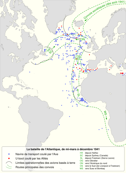
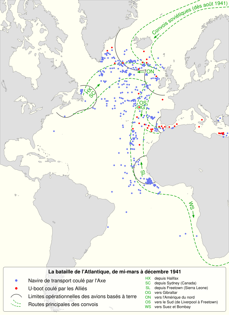
English: The battle of the Atlantic, mid-march to december 1941. In the latter part of April, sweeps and searches replaced close escort. In May 1941 these extends 350 miles from Iceland and Northern Ireland.
Français : La bataille de l'Atlantique, entre la mi-mars et décembre 1941. À partir de fin avril, les recherches aériennes de sous-marins remplacent les escortes rapprochées. En mai 1941, ces recherches s'étendent à 350 miles (~ 560 kilomètres) de l'Islande et l'Irlande du Nord.
|
||
| 日付 | (UTC) | ||
| 原典 |
投稿者自身による著作物. Source :
|
||
| 作者 | Sémhur (talk) | ||
| その他のバージョン |
このファイルの派生的著作物: | ||
| 帰属 (ライセンスによる要求事項) | © Sémhur / Wikimedia Commons / | ||
| SVG | W3C-validity not checked.
|
||
| Graphic Lab |

_-_German_submarines_lost-fr.svg)
| カメラの位置 | | 以下のサービスでこの位置を確認する: オープンストリートマップ |
|---|
ライセンス
| コピーレフト: この芸術作品はフリーです。あなたは、自由芸術ライセンスの規約に従うことで、再配布や改変が可能です。このライセンスの見本は、Copyleft Attitude または他のウェブサイトで見ることができます。 |
- あなたは以下の条件に従う場合に限り、自由に
- 共有 – 本作品を複製、頒布、展示、実演できます。
- 再構成 – 二次的著作物を作成できます。
- あなたの従うべき条件は以下の通りです。
- 表示 – あなたは適切なクレジットを表示し、ライセンスへのリンクを提供し、変更があったらその旨を示さなければなりません。これらは合理的であればどのような方法で行っても構いませんが、許諾者があなたやあなたの利用行為を支持していると示唆するような方法は除きます。
- 継承 – もしあなたがこの作品をリミックスしたり、改変したり、加工した場合には、あなたはあなたの貢献部分を元の作品とこれと同一または互換性があるライセンスの下に頒布しなければなりません。
元のアップロードログ
This image is a derivative work of the following images:
- File:Convoy_routes_1941.jpg licensed with PD-UKGov
- 2009-03-26T15:41:23Z Gonzosft 800x1314 (242200 Bytes) {{Information |Description={{en|1=THE BATTLE OF THE ATLANTIC (III), MID-MARCH–DECEMBER 1941}} |Source=http://www.archive.org/index.php |Author=Dennis Richards, HMSO, LONDON |Date=1953 |Permission={{PD-BritishGov}} |other
Uploaded with derivativeFX
ファイルの履歴
過去の版のファイルを表示するには、その版の日時をクリックしてください。
| 日付と時刻 | サムネイル | 寸法 | 利用者 | コメント | |
|---|---|---|---|---|---|
| 現在の版 | 2020年10月7日 (水) 10:58 | | 1,447 × 1,990 (411キロバイト) | Msmazores2019 | File uploaded using svgtranslate tool (https://svgtranslate.toolforge.org/). Added translation for pt. |
| 2011年10月17日 (月) 07:53 |  | 1,447 × 1,990 (447キロバイト) | Sémhur | Modification d'un texte de légende | |
| 2011年10月13日 (木) 17:46 |  | 1,447 × 1,990 (402キロバイト) | Sémhur | Precision | |
| 2011年10月12日 (水) 19:55 |  | 1,447 × 1,990 (393キロバイト) | Sémhur | Correct size | |
| 2011年10月12日 (水) 19:49 |  | 512 × 704 (389キロバイト) | Sémhur | == {{int:filedesc}} == {{Information |Description={{Multilingual description |en= The battle of the Atlantic, mid-march to december 1941.<br> In the latter part of April, sweeps and searches replaced close esco |
ファイルの使用状況
以下のページがこのファイルを使用しています:
グローバルなファイル使用状況
以下に挙げる他のウィキがこの画像を使っています: