ファイル:USA Mass Cape Cod location map.svg

この SVG ファイルのこの PNG プレビューのサイズ: 560 × 420 ピクセル. その他の解像度: 320 × 240 ピクセル | 640 × 480 ピクセル | 1,024 × 768 ピクセル | 1,280 × 960 ピクセル | 2,560 × 1,920 ピクセル。
元のファイル (SVG ファイル、560 × 420 ピクセル、ファイルサイズ: 264キロバイト)
ウィキメディア・コモンズのファイルページにある説明を、以下に表示します。
|
概要
| 解説 |
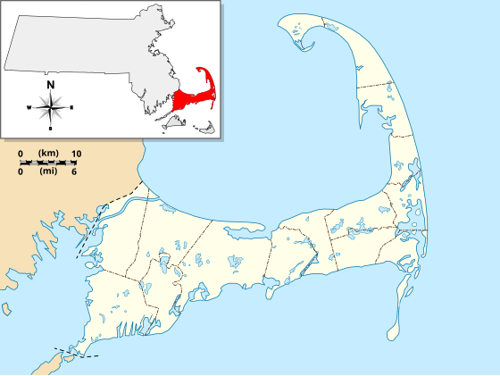
English: Location Map specific to (and zoomed to) Cape Cod, made specifically for the "WikiProject Massachusetts - Cape Cod and the Islands" on the English Wikipedia, but it is available to all.
For detailed instructions and several examples showing the various ways to use this file, see the documentation page at en:Module:Location map/data/USA Cape Cod. Specifications:
|
| 日付 | |
| 原典 | 投稿者自身による著作物 |
| 作者 | Grolltech |
| その他のバージョン |
このファイルの派生元: USA Massachusetts location map.svg: |
| SVG 開発 |
ライセンス
この作品の著作権者である私は、この作品を以下のライセンスで提供します。
このファイルはクリエイティブ・コモンズ 表示-継承 3.0 非移植ライセンスのもとに利用を許諾されています。
- あなたは以下の条件に従う場合に限り、自由に
- 共有 – 本作品を複製、頒布、展示、実演できます。
- 再構成 – 二次的著作物を作成できます。
- あなたの従うべき条件は以下の通りです。
- 表示 – あなたは適切なクレジットを表示し、ライセンスへのリンクを提供し、変更があったらその旨を示さなければなりません。これらは合理的であればどのような方法で行っても構いませんが、許諾者があなたやあなたの利用行為を支持していると示唆するような方法は除きます。
- 継承 – もしあなたがこの作品をリミックスしたり、改変したり、加工した場合には、あなたはあなたの貢献部分を元の作品とこれと同一または互換性があるライセンスの下に頒布しなければなりません。
ファイルの履歴
過去の版のファイルを表示するには、その版の日時をクリックしてください。
| 日付と時刻 | サムネイル | 寸法 | 利用者 | コメント | |
|---|---|---|---|---|---|
| 現在の版 | 2013年5月13日 (月) 11:25 | | 560 × 420 (264キロバイト) | Grolltech | reshaped Monomoy; added overlay layers to facilitate reuse of this file |
| 2013年5月7日 (火) 22:45 |  | 560 × 420 (189キロバイト) | Grolltech | further reduced thickness of town boundaries, land outlines | |
| 2013年5月6日 (月) 08:10 |  | 560 × 420 (206キロバイト) | Grolltech | moved compass rose out of the way | |
| 2012年5月31日 (木) 17:39 |  | 560 × 420 (205キロバイト) | Grolltech | 1) moved scale legend to the left edge, and 2) reduced thickness of town boundaries, land outlines, lakes and ponds. Both of these changes are intended lessen the impact on readability of pushpin labels. | |
| 2012年5月13日 (日) 17:21 |  | 560 × 420 (206キロバイト) | Grolltech | added town boundaries | |
| 2012年5月13日 (日) 05:51 |  | 560 × 420 (190キロバイト) | Grolltech | {{Information |Description ={{en|1=Locator Map for Cape Cod exclusively. Made for "Wikiproject Massachusetts - Cape Cod and the Islands". Equirectangular projection, N/S stretching 130.0 %. Geographic limits of the map: Northern boundary: 42.104... |
ファイルの使用状況
以下の 10 ページがこのファイルを使用しています:
グローバルなファイル使用状況
以下に挙げる他のウィキがこの画像を使っています:
- ar.wikipedia.org での使用状況
- azb.wikipedia.org での使用状況
- ceb.wikipedia.org での使用状況
- en.wikipedia.org での使用状況
- Cape Cod
- Cape Cod Canal
- Provincetown Harbor
- Cape Cod Baseball League
- Eastham Windmill
- Sagamore Beach, Massachusetts
- Attaquin Beach
- Provincetown Historic District
- Race Point Light
- Center Methodist Church
- Provincetown Public Library (old)
- North Truro Air Force Station
- South Harwich, Massachusetts
- Hyannis Armory
- Louis Brandeis House
- Nauset Archeological District
- Ancient Burying Ground
- Chatham Windmill
- First Universalist Church (Provincetown, Massachusetts)
- Adams-Crocker-Fish House
- South Harwich Methodist Church
- Osterville Baptist Church
- Old Higgins Farm Windmill
- Universalist Society Meetinghouse
- Poor House and Methodist Cemetery
- Cove Burying Ground
- Bridge Road Cemetery
- Old Indian Meeting House
- Ahearn House and Summer House
- Josiah A. Ames House
- Atwood–Higgins Historic District
- Barnstable County Courthouse
- Avant House (Mashpee, Massachusetts)
- Capt. Rodney J. Baxter House
- George I. Briggs House
- Benjamin Baker Jr. House
- Capt. Seth Baker Jr. House
- Nathaniel Baker House
- Baxter Mill
- Lemuel B. Chase House
- Canary-Hartnett House
- Brewster Old King's Highway Historic District
- Thomas Bray Farm
このファイルのグローバル使用状況を表示する。