ファイル:ValcourIslandMap1776Detail.jpg

このプレビューのサイズ: 541 × 599 ピクセル。 その他の解像度: 217 × 240 ピクセル | 434 × 480 ピクセル | 803 × 889 ピクセル。
元のファイル (803 × 889 ピクセル、ファイルサイズ: 337キロバイト、MIME タイプ: image/jpeg)
ウィキメディア・コモンズのファイルページにある説明を、以下に表示します。
|
概要
| 解説 |
English:
 |
||
| 日付 | |||
| 原典 |
From the Boston Public Library Digital Maps Collection (http://maps.bpl.org/). |
||
| 作者 |
ライセンス
|
この著作物は、著作権の保護期間が著作者の死後100年以下である国・地域においてパブリックドメインの状態にあります。 | |
| このファイルは著作権法の既知の制約(隣接権や関連する権利を含む)から自由であると特定されています。 | |
ファイルの履歴
過去の版のファイルを表示するには、その版の日時をクリックしてください。
| 日付と時刻 | サムネイル | 寸法 | 利用者 | コメント | |
|---|---|---|---|---|---|
| 現在の版 | 2009年2月17日 (火) 21:29 | | 803 × 889 (337キロバイト) | Magicpiano | Higher-res version. |
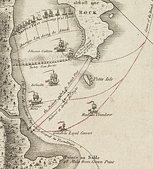
| 2009年2月17日 (火) 21:23 |  | 189 × 214 (23キロバイト) | Magicpiano | {{Information |Description={{en|1=thumb|right|source map showing area detailed in this image This is a blowup of the area highlighted in the map shown to the right, showing the detail of the action in the [[w:Bat |
ファイルの使用状況
以下のページがこのファイルを使用しています:
グローバルなファイル使用状況
以下に挙げる他のウィキがこの画像を使っています:
- ca.wikipedia.org での使用状況
- de.wikipedia.org での使用状況
- en.wikipedia.org での使用状況
- es.wikipedia.org での使用状況
- fi.wikipedia.org での使用状況
- fr.wikipedia.org での使用状況
- it.wikipedia.org での使用状況
- no.wikipedia.org での使用状況
- ru.wikipedia.org での使用状況
- simple.wikipedia.org での使用状況
- www.wikidata.org での使用状況