ファイル:WW2-Holocaust-Europe.png

元のファイル (1,310 × 1,090 ピクセル、ファイルサイズ: 639キロバイト、MIME タイプ: image/png)
ウィキメディア・コモンズのファイルページにある説明を、以下に表示します。
|
概要
| 解説 |
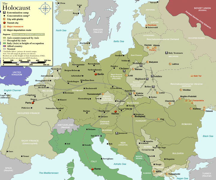
Map of the Holocaust in Europe during World War II, 1939-1945.
|
| 日付 | |
| 原典 | Self-made by User:Dna-Dennis, using information from USHMM & Wikipedia. |
| 作者 | User:Dna-Dennis |
| 許可 (ファイルの再利用) |
CC, see below. The map is completely unrestricted for any Wikipedia/Wikimedia project. |
| その他のバージョン |
[]
|


.png)


.png)


.png)

|
このファイルのベクター画像 (SVG) が利用できます。 使う目的に対し、元画像よりもSVGがより優れている場合、SVG画像を使用して下さい。
File:WW2-Holocaust-Europe.png → File:WW2 Holocaust Europe map-fr.svg
|
 |
ライセンス
- あなたは以下の条件に従う場合に限り、自由に
- 共有 – 本作品を複製、頒布、展示、実演できます。
- 再構成 – 二次的著作物を作成できます。
- あなたの従うべき条件は以下の通りです。
- 表示 – あなたは適切なクレジットを表示し、ライセンスへのリンクを提供し、変更があったらその旨を示さなければなりません。これらは合理的であればどのような方法で行っても構いませんが、許諾者があなたやあなたの利用行為を支持していると示唆するような方法は除きます。
ファイルの履歴
過去の版のファイルを表示するには、その版の日時をクリックしてください。
| 日付と時刻 | サムネイル | 寸法 | 利用者 | コメント | |
|---|---|---|---|---|---|
| 現在の版 | 2009年10月29日 (木) 13:57 | | 1,310 × 1,090 (639キロバイト) | Flying Saucer | moved Vaivara to it's right place |
| 2007年12月20日 (木) 03:41 |  | 1,310 × 1,090 (826キロバイト) | Dna-webmaster~commonswiki | new version without "Axis cooperating" in legend | |
| 2007年12月20日 (木) 02:00 |  | 1,310 × 1,090 (824キロバイト) | Dna-webmaster~commonswiki | Now entire West Prussia and Wartheland is included in the Third Reich | |
| 2007年12月19日 (水) 16:42 |  | 1,310 × 1,090 (828キロバイト) | Dna-webmaster~commonswiki | still not Da Vinci, but errors have been corrected (Germany borders West/East), West & East Prussia borders/coloring and Poland General Government corrected borders. | |
| 2007年12月17日 (月) 10:46 |  | 1,310 × 1,090 (825キロバイト) | Dna-webmaster~commonswiki | new map with 1942 borders, not Da Vinci, but here it goes... | |
| 2007年10月19日 (金) 13:32 |  | 1,310 × 1,090 (766キロバイト) | Dna-webmaster~commonswiki | and another update | |
| 2007年10月19日 (金) 12:21 |  | 1,310 × 1,090 (771キロバイト) | Dna-webmaster~commonswiki | quick fix | |
| 2007年10月19日 (金) 12:11 |  | 1,310 × 1,090 (771キロバイト) | Dna-webmaster~commonswiki | {{Information |Description=Map of the Holocaust in Europe during World War II, 1939-1945. <br> This map shows all extermination camps (or ''death camps''), most major concentration camps, work camps, prison camps, ghettos, major deportation routes and maj |
ファイルの使用状況
以下の 3 ページがこのファイルを使用しています:
グローバルなファイル使用状況
以下に挙げる他のウィキがこの画像を使っています:
- af.wikipedia.org での使用状況
- ar.wikipedia.org での使用状況
- az.wikipedia.org での使用状況
- be-tarask.wikipedia.org での使用状況
- be.wikipedia.org での使用状況
- bn.wikipedia.org での使用状況
- ca.wikipedia.org での使用状況
- cs.wikipedia.org での使用状況
- de.wikipedia.org での使用状況
- el.wikipedia.org での使用状況
- en.wikipedia.org での使用状況
- Auschwitz concentration camp
- Extermination camp
- Sobibor extermination camp
- Drancy internment camp
- White Buses
- Vel' d'Hiv Roundup
- Template:Image frame
- German war crimes
- René Bousquet
- Holocaust trains
- Portal:Genocide/Selected article
- Portal:Genocide/Selected article/8
- Mechelen transit camp
- User:Dna-webmaster/Projects
- Jewish ghettos in Europe
- List of Jewish ghettos in Europe during World War II
- Template:Image frame/doc
- User:Jnestorius/Resources
- Wikipedia:Featured picture candidates/January-2015
- Wikipedia:Featured picture candidates/Map of the Holocaust in Europe
- The Holocaust in Hungary
- Emigration of Jews from Nazi Germany and German-occupied Europe
- Talk:The Holocaust/Archive 31
- Template:Image frame/sandbox
- Reich Security Head Office Referat IV B4
- Genocides in history (World War I through World War II)
- User:Buidhe/fork
- en.wikibooks.org での使用状況
- es.wikipedia.org での使用状況
- fa.wikipedia.org での使用状況
- fi.wikipedia.org での使用状況
- fi.wikibooks.org での使用状況
- fr.wikipedia.org での使用状況
このファイルのグローバル使用状況を表示する。