元のファイル(2,007 × 2,161 ピクセル、ファイルサイズ: 1.34メガバイト、MIME タイプ: image/png)

この地図画像は、ベクターイメージである SVG ファイルとして再作成されるべきです。これにはいくつかの利点があります。詳しくはCommons:Media for cleanupを参照してください。この画像の SVG 形式がすでに利用可能である場合は、アップロードしてください。アップロード後、この画像にあるこのテンプレートを{{Vector version available|新しい画像ファイル名.svg}}テンプレートで置き換えてください。

概要

解説
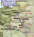
English: Map of the Holocaust in occupied Poland during World War II. The outline shows the borders of the Second Polish Republic at the time of the Nazi-German-and-Soviet invasion of Poland in 1939 with demarcation line between the two invading armies marked in red. Internal boundaries show the administrative divisions of occupied territories imposed by Nazi Germany when the Final Solution was set in motion during and after Operation Barbarossa of 1941.
This map shows all Nazi German extermination camps (or death camps), as well as prominent concentration, labour and prison camps, major pre-WW2 Polish cities with the new Jewish ghettos set up by Nazi Germany, major deportation routes, and major massacre sites.
Notes:
1. Extermination camps – marked with white skulls in black squares – are six dedicated facilities used for the mass gassings of prisoners, but all camps and ghettos took a toll of many, many lives.
2. Concentration camps – marked with black squares – feature only the most notorious forced-labor camps, prison camps & transit camps.
3. Sites of mass shootings into remote ravines – marked with white skulls – include Bronna Góra, Ponary and others. They were utilized during the 'Holocaust by bullets'.
4. Destruction ghettos – marked with Yellow stars in red circles – existed in most Polish cities. Only a selection is shown.
5. Major deportation routes travelled by the Holocaust trains are marked with RosyBrown arrows.
6. Most camps & ghettos which are not well known have been excluded for clarity.
7. District borders are at the height of Axis domination (1942).
8. Regions have German designations (e.g. "Ostland"), with the country name denoted in uppercase letters, e.g. LITHUANIA, CZECHOSLOVAKIA, or in parenthesis below the German occupational designation, e.g. (POLAND).

日付
原典

投稿者自身による著作物. Composite map derived from a variety of readily available sources which may or may not include:

作者
許可
(ファイルの再利用)
PD, see below. The map is completely unrestricted for any Wikipedia/Wikimedia project.
その他のバージョン

[編集]

ヨーロッパ 1942
ヨーロッパ 2007
ポーランド
ウクライナ
オストラント帝国委員管区
Northeast Europe
このファイルの派生的著作物:  San Francisco - ASA Confernece 2009 - Wikipedia map used.JPG

ライセンス

For all derivative works of maps uploaded earlier see below.

この作品の著作権者であるPoeticbent (en)は、この作品を以下のライセンスで提供しています。
Public domain この著作物の著作権者である私は、この著作物における権利を放棄しパブリックドメインとします。これは全世界で適用されます。
一部の国では、これが法的に可能ではない場合があります。その場合は、次のように宣言します。
私は、あらゆる人に対して、法により必要とされている条件を除き、如何なる条件も課すことなく、あらゆる目的のためにこの著作物を使用する権利を与えます。
File uploaded previously
この作品の著作権者であるDennis Nilssonは、この作品を以下のライセンスで提供しています。
w:ja:クリエイティブ・コモンズ
表示
このファイルはクリエイティブ・コモンズ 表示 3.0 非移植ライセンスのもとに利用を許諾されています。
帰属: Dennis Nilsson
あなたは以下の条件に従う場合に限り、自由に
  • 共有 – 本作品を複製、頒布、展示、実演できます。
  • 再構成 – 二次的著作物を作成できます。
あなたの従うべき条件は以下の通りです。
  • 表示 – あなたは適切なクレジットを表示し、ライセンスへのリンクを提供し、変更があったらその旨を示さなければなりません。これらは合理的であればどのような方法で行っても構いませんが、許諾者があなたやあなたの利用行為を支持していると示唆するような方法は除きます。

Derivative work: Piotr Konieczny aka Prokonsul Piotrus Talk このファイルの派生的著作物:

Derivative work: User:Poeticbent (Talk) このファイルの派生的著作物:

Uploaded previously
この画像には画像編集が施されています。原本に対して次のデジタル的な変更が行われました。
編集内容:Smaller version: occupied Poland only (pre-WWII borders)
編集前の原本:WW2-Holocaust-Europe.png

この作品の著作権者である私は、この作品を以下のライセンスで提供します。
w:ja:クリエイティブ・コモンズ
表示
このファイルはクリエイティブ・コモンズ 表示 3.0 非移植ライセンスのもとに利用を許諾されています。
あなたは以下の条件に従う場合に限り、自由に
  • 共有 – 本作品を複製、頒布、展示、実演できます。
  • 再構成 – 二次的著作物を作成できます。
あなたの従うべき条件は以下の通りです。
  • 表示 – あなたは適切なクレジットを表示し、ライセンスへのリンクを提供し、変更があったらその旨を示さなければなりません。これらは合理的であればどのような方法で行っても構いませんが、許諾者があなたやあなたの利用行為を支持していると示唆するような方法は除きます。

元のアップロードログ

For derivative works of the first uploaded file created by User:Dna-webmaster see the following:

Uploaded with derivativeFX

キャプション

このファイルの内容を1行で記述してください
Holocaust in occupied Poland

このファイルに描写されている項目

題材

27 6 2013

ファイルの履歴

過去の版のファイルを表示するには、その版の日時をクリックしてください。

(最新 | 最古) (以後の10件 | ) (10 | 20 | 50 | 100 | 250 | 500 件) を表示
日付と時刻サムネイル寸法利用者コメント
現在の版2020年3月10日 (火) 15:462020年3月10日 (火) 15:46時点における版のサムネイル2,007 × 2,161 (1.34メガバイト)Claude ZygielCosmetics
2018年3月28日 (水) 20:332018年3月28日 (水) 20:33時点における版のサムネイル2,007 × 2,161 (1.48メガバイト)Poeticbentnot an improvement: img looks muddy but I have original Photoshop layers, and can adjust them individually; comment on specifics in talk please
2018年3月27日 (火) 17:482018年3月27日 (火) 17:48時点における版のサムネイル2,007 × 2,161 (1.49メガバイト)HohumToo much information competing for attention in a very busy image. Toned down region name brightness, desaturated slightly.
2017年7月10日 (月) 05:382017年7月10日 (月) 05:38時点における版のサムネイル2,007 × 2,161 (1.48メガバイト)Poeticbentvital updates following a discussion → prominent ghettos, legend
2015年7月25日 (土) 19:432015年7月25日 (土) 19:43時点における版のサムネイル2,007 × 2,161 (1.46メガバイト)Poeticbentname of settlement: Górka Połonka, source Wolyn.ovh.org
2014年12月2日 (火) 18:272014年12月2日 (火) 18:27時点における版のサムネイル2,007 × 2,161 (1.46メガバイト)Poeticbentadded one missing marker
2014年5月7日 (水) 19:172014年5月7日 (水) 19:17時点における版のサムネイル2,007 × 2,161 (1.45メガバイト)Poeticbentlocation of Bronna Góra
2014年4月4日 (金) 17:342014年4月4日 (金) 17:34時点における版のサムネイル2,007 × 2,161 (1.44メガバイト)PoeticbentLachwa Ghetto location
2013年6月27日 (木) 21:312013年6月27日 (木) 21:31時点における版のサムネイル2,007 × 2,161 (1.42メガバイト)Poeticbentmajor expansion with similar color-scheme
2011年6月28日 (火) 03:092011年6月28日 (火) 03:09時点における版のサムネイル364 × 339 (123キロバイト)LMK3changed the color of the Soviet Curzon line to indicate the two different occupation zones before Operation Barbarossa, refined the location of Warsaw
(最新 | 最古) (以後の10件 | ) (10 | 20 | 50 | 100 | 250 | 500 件) を表示

以下の​ 3 ページがこのファイルを使用しています:

グローバルなファイル使用状況

以下に挙げる他のウィキがこの画像を使っています:

このファイルのグローバル使用状況を表示する。

メタデータ