ファイル:Warming Island USGS Landsat.jpg
高解像度版はありません。
Warming_Island_USGS_Landsat.jpg (800 × 262 ピクセル、ファイルサイズ: 56キロバイト、MIME タイプ: image/jpeg)
ウィキメディア・コモンズのファイルページにある説明を、以下に表示します。
|
| 解説 |
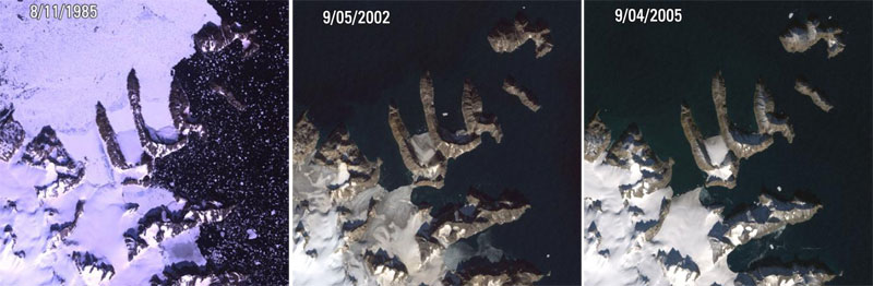
Warming Island, Greenland L5, L7 ETM+ Acquisition Date: Aug 11, 1985 & Sep 05, 2002 & Sep 04, 2005 Path/Row: 227/9 Lat/Long: 72.207/-22.180 On January 16th, 2007, the New York Times reported that a new island had been found in Greenland. Warming Island was once thought to be an ice-covered peninsula, but it was exposed as an island when a glacier melted to reveal the strait. This image shows satellite pictures of the island in 1985 when the glacier had firmly tied it to the mainland, in 2002 when there was only a thin bridge of ice, and in 2005 when the bridge of ice has broken to reveal an open water strait. More islands like this may be discovered if the Greenland ice sheet continues to disappear. |
| 日付 | 1985年と2005年の間 |
| 原典 |
|
| 作者 | USGS Landsat |
| 許可 (ファイルの再利用) |
PD-USGov-Interior-USGS |
この画像およびメディアは、アメリカ合衆国内務省の実務機関であるアメリカ地質調査所に属する者が職務上作成した著作物のみで構成されているため、アメリカ合衆国国内でパブリックドメインの状態にあります。詳細についてはUSGSの著作物に関する取扱い(英語)をご覧ください。
|
ファイルの履歴
過去の版のファイルを表示するには、その版の日時をクリックしてください。
| 日付と時刻 | サムネイル | 寸法 | 利用者 | コメント | |
|---|---|---|---|---|---|
| 現在の版 | 2008年12月3日 (水) 21:15 | 800 × 262 (56キロバイト) | RaviC | {{Information |Description=Warming Island, Greenland L5, L7 ETM+ Acquisition Date: Aug 11, 1985 & Sep 05, 2002 & Sep 04, 2005 Path/Row: 227/9 Lat/Long: 72.207/-22.180 On January 16th, 2007, the New York Times reported that a new island had been found in |
ファイルの使用状況
以下の 2 ページがこのファイルを使用しています:
グローバルなファイル使用状況
以下に挙げる他のウィキがこの画像を使っています:
- ar.wikipedia.org での使用状況
- az.wikipedia.org での使用状況
- en.wikipedia.org での使用状況
- es.wikipedia.org での使用状況
- hy.wikipedia.org での使用状況
- it.wikipedia.org での使用状況
- nl.wikipedia.org での使用状況
- pl.wikipedia.org での使用状況
- ru.wikipedia.org での使用状況
- uk.wikipedia.org での使用状況
- vi.wikipedia.org での使用状況