「バーンクラー郡」の版間の差分
en:Amphoe Bang Khla 16:26, 24 September 2007 UTCの版を移入 |
(相違点なし)
|
2008年4月6日 (日) 08:24時点における版
テンプレートの呼び出しエラー: 廃止されたTemplate:翻訳中が呼び出されています。 {{翻訳中 を {{翻訳中途 としてください。この項目「バーンクラー郡」は途中まで翻訳されたものです。 テンプレートの呼び出しエラー: 翻訳元の指定は必須です。 1=[翻訳元への固定リンク 翻訳元の版情報]としてください。 |
Bang Khla (タイ語: บางคล้า) is a district (Amphoe) of Chachoengsao Province, central Thailand.
| バーンクラー郡 | |
|---|---|
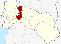
 {{{ja_name}}}の位置 | |
| 情報 | |
| タイ語名 | บางคล้า |
| 県 | Chachoengsao |
| 地理番号 | 2402 |
| 郵便番号 | 24110 |
| 統計 | |
| 面積 | 227.9 km2 |
| 人口 | 46,539 人 (2000年) |
| 人口密度 | 204.2 人/km2 |
| 行政 | |
| 座標 | 北緯13度43分42秒 東経101度12分30秒 / 北緯13.72833度 東経101.20833度 |
History
Bang Khla district was established in 1901. The district office was located in Wat Mai Bang Khla, nowadays in Tambon Ban Suan. Bang Khla is the name of the village Ban Bang Khla, which is located at the Khlong (canal) Bang Khla. As the district office was not in the center of the district area, the government moved it to Tambon Tao Sura, 5 km from the old location. Later they changed the name of the tambon to Bang Khla to fit with the district name.
Geography
Neighboring districts are (from the east clockwise) Ratchasan, Plaeng Yao, Ban Pho, Mueang Chachoengsao, Khlong Khuean of Chachoengsao Province and Ban Sang of Prachinburi Province.
The important water resource is the Bang Pakong River.
Administration
The district is subdivided into 8 subdistricts (tambon), which are further subdivided into 56 villages (muban). Bang Khla and Pak Nam are two townships (thesaban tambon), each covering the complete same-named tambon. There are further 8 Tambon administrative organizations (TAO).
| 1. | Bang Khla | บางคล้า | |
| 4. | Bang Suan | บางสวน | |
| 8. | Bang Krachet | บางกระเจ็ด | |
| 9. | Pak Nam | ปากน้ำ | |
| 10. | Tha Thonglang | ท่าทองหลาง | |
| 11. | Sao Cha-ngok | สาวชะโงก | |
| 12. | Samet Nuea | เสม็ดเหนือ | |
| 13. | Samet Tai | เสม็ดใต้ | |
| 14. | Hua Sai | หัวไทร |
Missing numbers are the tambon which now form the district Khlong Khuean.
Sources
- Bang Khla district history (Thai)