ファイル:1902 Subig Bay (Subic Bay) Luzon, Philippines nautical chart 4254, by Manila Sub Office, United States Coast and Geodetic Survey.jpg

このプレビューのサイズ: 476 × 600 ピクセル。 その他の解像度: 190 × 240 ピクセル | 381 × 480 ピクセル | 610 × 768 ピクセル | 813 × 1,024 ピクセル | 1,626 × 2,048 ピクセル | 2,672 × 3,366 ピクセル。
元のファイル (2,672 × 3,366 ピクセル、ファイルサイズ: 1.21メガバイト、MIME タイプ: image/jpeg)
ウィキメディア・コモンズのファイルページにある説明を、以下に表示します。
|
概要
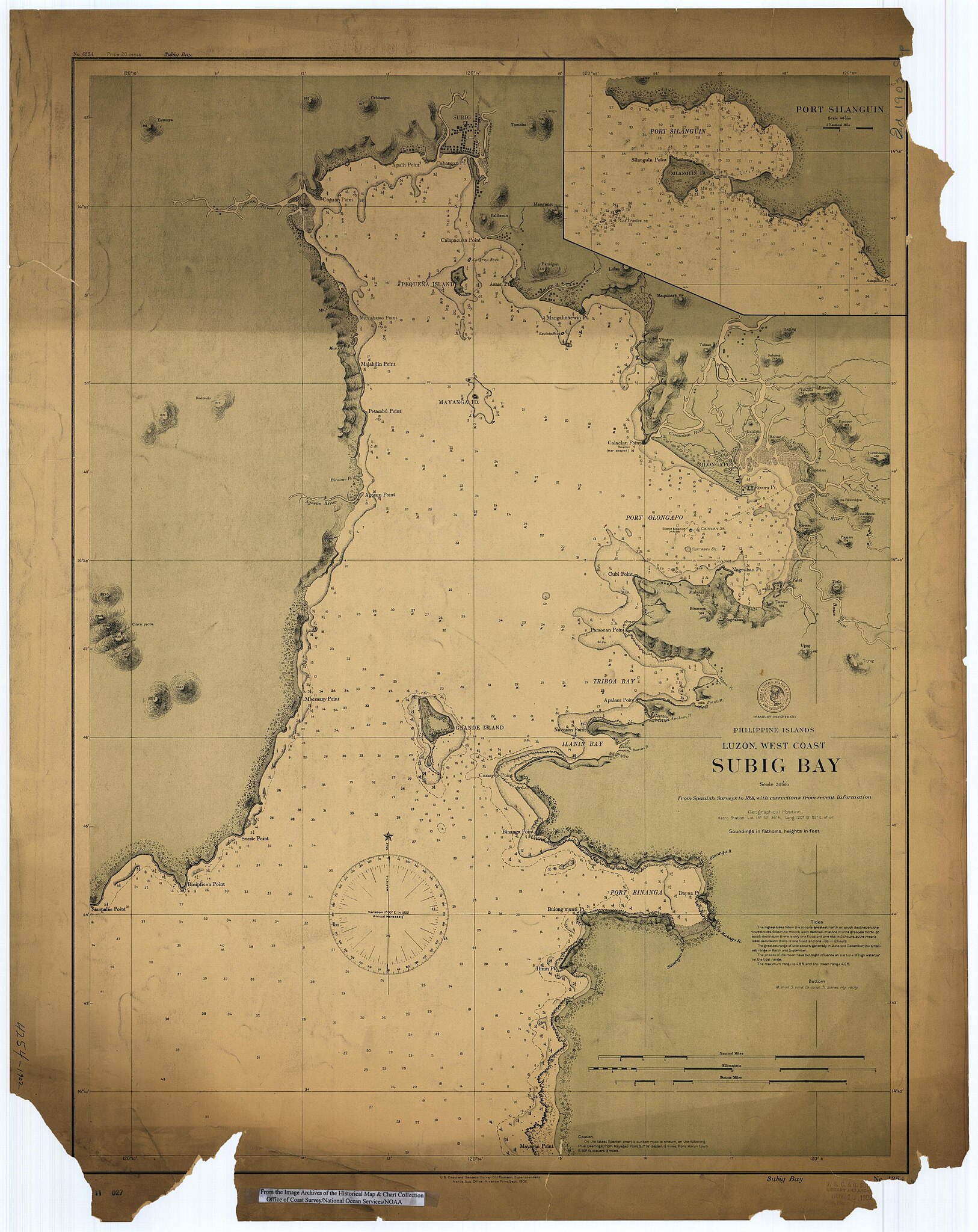
Scanned image of US Coast & Geodetic Survey Manila Office nautical chart #4254 Subig (Subic) Bay, Luzon, Philippines, 1902.
From the Image Archives of the Historical Map & Chart Collection アーカイブされたコピー at the Wayback Machine/Office of Coast Survey/National Ocean Service/NOAA/United States government. Converted from MrSID to JPEG format for upload to Commons.
_4254,_by_Manila_Sub_Office,_United_States_Coast_and_Geodetic_Survey_(cropped).jpg)
_Luzon,_Philippines_nautical_chart_4254,_by_Manila_Sub_Office,_United_States_Coast_and_Geodetic_Survey.jpg?uselang=ja)
_Luzon,_Philippines_nautical_chart_4254,_by_Manila_Sub_Office,_United_States_Coast_and_Geodetic_Survey.jpg?uselang=ja)
_Luzon,_Philippines_nautical_chart_4254,_by_Manila_Sub_Office,_United_States_Coast_and_Geodetic_Survey.jpg?uselang=ja&action=history)
_Luzon,_Philippines_nautical_chart_4254,_by_Manila_Sub_Office,_United_States_Coast_and_Geodetic_Survey.jpg)
ライセンス
|
|
ファイルの履歴
過去の版のファイルを表示するには、その版の日時をクリックしてください。
| 日付と時刻 | サムネイル | 寸法 | 利用者 | コメント | |
|---|---|---|---|---|---|
| 現在の版 | 2006年3月17日 (金) 01:02 | | 2,672 × 3,366 (1.21メガバイト) | Cdc~commonswiki | Scanned image of US Coast & Geodetic Survey Manila Office nautical chart #4254 Subig (Subic) Bay, Luzon, Philippines, 1902. From the Image Archives of the [http://chartmaker.ncd.noaa.gov/csdl/ctp/abstract.htm Historical Map & Chart Collection]/Office of |
ファイルの使用状況
以下のページがこのファイルを使用しています:
グローバルなファイル使用状況
以下に挙げる他のウィキがこの画像を使っています:
- ast.wikipedia.org での使用状況
- da.wikipedia.org での使用状況
- en.wikipedia.org での使用状況
- es.wikipedia.org での使用状況
- fr.wikipedia.org での使用状況
- id.wikipedia.org での使用状況
- nl.wikipedia.org での使用状況
- no.wikipedia.org での使用状況
- pt.wikipedia.org での使用状況
- ru.wikipedia.org での使用状況
- sv.wikipedia.org での使用状況
- tl.wikipedia.org での使用状況
- vi.wikipedia.org での使用状況
- www.wikidata.org での使用状況
- zh.wikipedia.org での使用状況
_Luzon,_Philippines_nautical_chart_4254,_by_Manila_Sub_Office,_United_States_Coast_and_Geodetic_Survey.jpg)