ファイル:Alignment Official Pakistan map 1962.jpg
元のファイル (600 × 616 ピクセル、ファイルサイズ: 59キロバイト、MIME タイプ: image/jpeg)
ウィキメディア・コモンズのファイルページにある説明を、以下に表示します。
|
概要

|
このhistorical map画像は、ベクターイメージである SVG ファイルとして再作成されるべきです。これにはいくつかの利点があります。詳しくはCommons:Media for cleanupを参照してください。この画像の SVG 形式がすでに利用可能である場合は、アップロードしてください。アップロード後、この画像にあるこのテンプレートを{{Vector version available|新しい画像ファイル名.svg}}テンプレートで置き換えてください。
|


| 解説 |
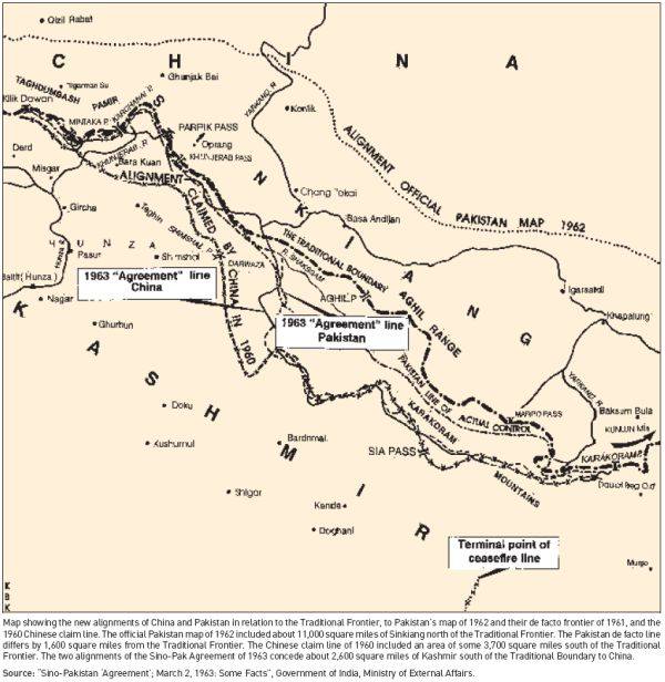
English: Map depicting the official alignment of the northern border of Kashmir in 1962 according to the Government of Pakistan |
| 日付 | |
| 原典 | Sino Pakistan "Agreement", March 2, 1963 "Some facts" published by the Government of India, Ministry of External Affairs |
| 作者 | The Government of India, Ministry of External Affairs |
| カメラの位置 | | 以下のサービスでこの位置を確認する: オープンストリートマップ |
|---|
The area pertains to the Cis-Kuen Lun Tract in northern Kashmir, the area in northern Kashmir which has been either annexed by the Chinese or is part of the area ceded by Pakistan to the Chinese. The Northern border of the Cis-Kuen Lun Tract is the area of Dafdar in the area of the Taghdumbash Pamir and Mariom Pamir and the mountain passes in northern Kashmir including inter alia the Kukalang Pass, Yangi Pass to the north of the Raskam area in Kanjut , the Kilian Pass, the Sanju-La Pass and the Hindutash Pass. The Government of Pakistan had published an official map depicting the alignment of the northern Border of Kashmir in 1962 which depicted much of the Cis-Kuen Lun Tract as part of Kashmir and the Times Atlas had predominantly depicted the Cis-Kuen Lun Tract as a part of Kashmir under the caption "Undefined Frontier area" in 1959.
ライセンス
この著作物は著作権の保護期間が満了したため、インドにおいてパブリックドメインにあります。インドの著作権法は、インドで最初に発行された著作物に対して適用されます。
1957年インド著作権法(第5章25節)では、無名の著作物、写真、映画作品、録音物、政府刊行物、団体名義の著作物及び国際機関の著作物は、最初の発行日から翌暦年で数えて60年後にパブリックドメインに置かれる、と定めています(例えば2024年においては1964年1月1日以前に発行された著作物がパブリックドメインにあると考えられます)。 著作者の死後に発行された著作物(上述したものは除きます。)は発行日から60年後にパブリックドメインに置かれます。その他の著作物は著作者の死後60年後にパブリックドメインに置かれます。法令、裁判所の見解、その他の政府の報告書には著作権が与えられていません。1958年以前に作成された写真は、1911年著作権法(英語版)によって、作成から50年後にパブリックドメインに置かれます。
|
 |
– India public domain images and sounds, 60 years after the end of the year of first publication, The subject matter of the photo or recording is also not protected by copyright.
ファイルの履歴
過去の版のファイルを表示するには、その版の日時をクリックしてください。
| 日付と時刻 | サムネイル | 寸法 | 利用者 | コメント | |
|---|---|---|---|---|---|
| 現在の版 | 2016年4月21日 (木) 13:56 | | 600 × 616 (59キロバイト) | Hindutashravi | User created page with UploadWizard |
ファイルの使用状況
以下のページがこのファイルを使用しています:
グローバルなファイル使用状況
以下に挙げる他のウィキがこの画像を使っています:
- en.wikipedia.org での使用状況
- pl.wikipedia.org での使用状況
- te.wikipedia.org での使用状況