ファイル:Atalaya (Peru) Rios Tambo+Ucayali.jpg
このプレビューのサイズ: 800 × 600 ピクセル。 その他の解像度: 320 × 240 ピクセル | 640 × 480 ピクセル | 1,024 × 768 ピクセル | 1,280 × 960 ピクセル | 2,560 × 1,920 ピクセル | 4,416 × 3,312 ピクセル。
元のファイル (4,416 × 3,312 ピクセル、ファイルサイズ: 1.76メガバイト、MIME タイプ: image/jpeg)
ウィキメディア・コモンズのファイルページにある説明を、以下に表示します。
|
_Rios_Tambo%2BUcayali.jpg?uselang=ja)
_Rios_Tambo%2BUcayali.jpg?uselang=ja)
_Rios_Tambo%2BUcayali.jpg?uselang=ja&action=history)
_Rios_Tambo%2BUcayali.jpg)
概要
| 解説 |
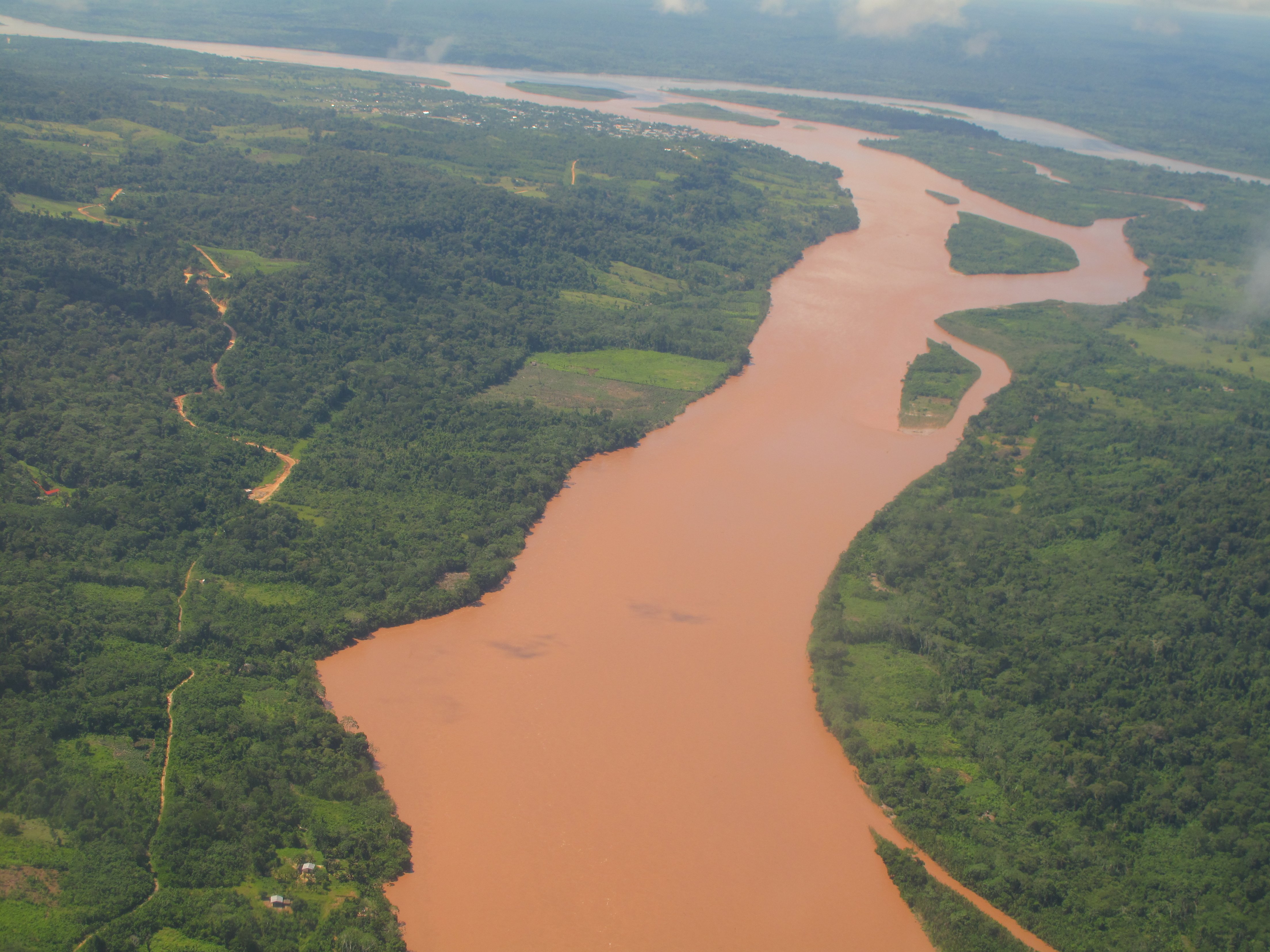
English: Aerial view of the confluence of the Río Tambo (from bottom to top) and the Río Urubamba (in the background, from right to left) forming the Río Ucayali (left). The city at the confluence is Atalaya in the Peruvian Region of Ucayali.
Deutsch: Luftbild des Zusammenflusses des Río Tambo (im Bild von vorne nach hinten fliessend) und des Río Urubamba (von rechts nach links) bei Atalaya (Ucayali, Peru). Der vereinte Fluss heisst von hier weg Ucayali (nach links fliessend).
Español: Vista aérea de la confluencia de los Ríos Tambo (delante) y Urubamba (derecha, al fondo) cerca de la ciudad de Atalaya (Región Ucayali, Perú), formando el Río Ucayali. |
| 日付 | |
| 原典 | 投稿者自身による著作物 |
| 作者 | Maurice Chédel |
ライセンス
| この著作物の著作権者である私は、この著作物における権利を放棄しパブリックドメインとします。これは全世界で適用されます。 一部の国では、これが法的に可能ではない場合があります。その場合は、次のように宣言します。 私は、あらゆる人に対して、法により必要とされている条件を除き、如何なる条件も課すことなく、あらゆる目的のためにこの著作物を使用する権利を与えます。 |
ファイルの履歴
過去の版のファイルを表示するには、その版の日時をクリックしてください。
| 日付と時刻 | サムネイル | 寸法 | 利用者 | コメント | |
|---|---|---|---|---|---|
| 現在の版 | 2010年4月12日 (月) 12:19 | | 4,416 × 3,312 (1.76メガバイト) | Altiplano | {{Information |Description={{en|1=Aerial view of the confluence of the Río Tambo (from bottom to top) and the Río Urubamba (in the background, from right to left) forming the Río Ucayali (left). The city at the confluence is Atalaya in the Peruvian Reg |
ファイルの使用状況
以下のページがこのファイルを使用しています:
グローバルなファイル使用状況
以下に挙げる他のウィキがこの画像を使っています:
- af.wikipedia.org での使用状況
- ar.wikipedia.org での使用状況
- arz.wikipedia.org での使用状況
- ast.wikipedia.org での使用状況
- ay.wikipedia.org での使用状況
- be.wikipedia.org での使用状況
- bg.wikipedia.org での使用状況
- bn.wikipedia.org での使用状況
- bs.wikipedia.org での使用状況
- ca.wikipedia.org での使用状況
- ceb.wikipedia.org での使用状況
- cv.wikipedia.org での使用状況
- de.wikipedia.org での使用状況
- en.wikipedia.org での使用状況
- eo.wikipedia.org での使用状況
- es.wikipedia.org での使用状況
- eu.wikipedia.org での使用状況
- fa.wikipedia.org での使用状況
- fr.wikipedia.org での使用状況
- fr.wikivoyage.org での使用状況
- gl.wikipedia.org での使用状況
- he.wikipedia.org での使用状況
- hr.wikipedia.org での使用状況
- hu.wikipedia.org での使用状況
- hy.wikipedia.org での使用状況
- id.wikipedia.org での使用状況
- it.wikipedia.org での使用状況
- kk.wikipedia.org での使用状況
- lt.wikipedia.org での使用状況
- ml.wikipedia.org での使用状況
- nl.wikipedia.org での使用状況
このファイルのグローバル使用状況を表示する。
_Rios_Tambo%2BUcayali.jpg)
_Rios_Tambo%2BUcayali.jpg)