ファイル:Attila in Gaul 451CE.svg

元のファイル (SVG ファイル、1,283 × 981 ピクセル、ファイルサイズ: 511キロバイト)
ウィキメディア・コモンズのファイルページにある説明を、以下に表示します。
|
概要
| 解説 |
Deutsch: Dies ist die deutschsprachige Diagrammversion, andere sind unten angegeben.
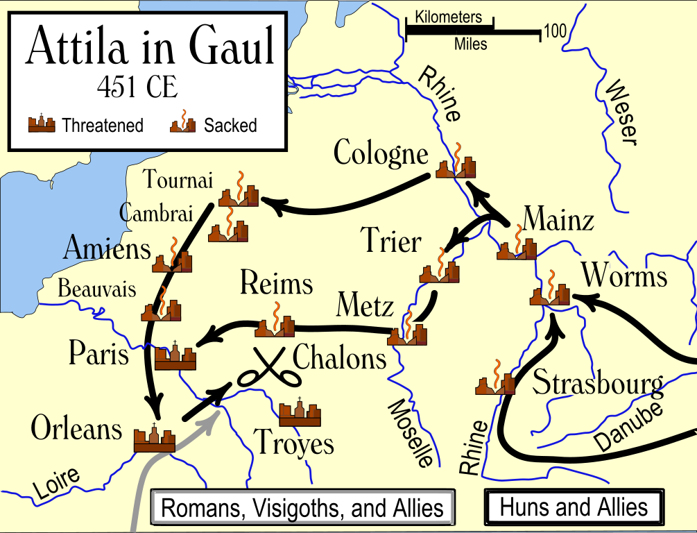
Das Diagramm zeigt die wahrscheinlichen Wege, die von den Hunnen bei ihrer Invasion Galliens 451 benutzt wurden, und die Schicksale der Städte auf ihrem Weg. Die verschiedenen Quellen ergeben widersprüchliche Information darüber, ob Städte geplündert wurden, insbesondere Trier. Es wird auch gesagt, daß einige Städte südöstlich von Troyes einschließlich Auxerre, Besancon und Langres geplündert wurden.English: An historical map showing the Hun invasion of Gaul in 451 CE (AD), leading to the Battle of Chalons. The generally accepted routes are shown, along with the larger cities threatened or sacked by the Huns. Français : Une carte historique montrant l'invasion des Huns de la Gaule en 451 Ap J-C, et la bataille des champs Catalauniques. Les itinéraires probables sont montrés, avec les villes plus grandes menacées ou pillées par les huns. Italiano: Carta storica che descrive l'invasione della Gallia da parte degli Unni nel 451 d.C., e la battaglia dei Campi Catalaunici. Sono mostrati i probabili itinerari, e le città conquistate o risparmiate dagli Unni. Nederlands: Een historische kaart die de invasie van de Hunnen en hun bondgenoten in Germania, Belgica en Gallia in het jaar 451 toont, en de Slag op de Catalaunische Velden. De waarschijnlijke routes zijn getoond maar deze zijn niet met zekerheid te geven, omdat de exacte dag van plundering en belegering in de meeste gevallen niet bekend is. 中文: 匈人入侵高卢,最终发生了沙隆战役。图中展示了普遍认同的双方进军路线,并标记了受到威胁或遭到劫掠的较大城市。 |
||||||||
| 原典 | 投稿者自身による著作物 | ||||||||
| 作者 | 投稿者自身による著作物 | ||||||||
| 許可 (ファイルの再利用) |
この作品の著作権者である私は、この作品を以下のライセンスで提供します。
あなたは上記のライセンスから、どれか一つ以上を選択できます。 |
||||||||
| その他のバージョン |
[]
|


References
- http://www.wargames.co.uk/Library/ArticlesH/Chalons.html アーカイブされたコピー at the Wayback Machine
- Attila the Hun and the Battle of Chalons by Arther Ferrill アーカイブされたコピー at the Wayback Machine
- Various other sources including the Catholic Encyclopedia articles on the various cities.
Various sources give conflicting information on whether some cities were sacked, in particular Trier. Man says "no", while Ferrill says "yes". Most other sources agree with Ferrill. There are also several cities southeast of Troyes which were said to have been sacked, including Auxerre, Besancon, and Langres.
In order to be as understandable as possible to the average reader, I have used the modern-day names of the towns, rather than the names used in 451 CE.
ファイルの履歴
過去の版のファイルを表示するには、その版の日時をクリックしてください。
| 日付と時刻 | サムネイル | 寸法 | 利用者 | コメント | |
|---|---|---|---|---|---|
| 現在の版 | 2009年4月3日 (金) 03:50 | | 1,283 × 981 (511キロバイト) | Goldsztajn | removing red-blue colours to black/grey. |
| 2006年11月14日 (火) 17:40 |  | 1,283 × 981 (510キロバイト) | MapMaster | I did it right this time (I hope). The problem is that I don't have a good SVG preview capability. | |
| 2006年11月14日 (火) 17:22 |  | 1,182 × 948 (510キロバイト) | MapMaster | I truly uploaded an improved version this time. Honest | |
| 2006年11月14日 (火) 17:07 |  | 1,182 × 948 (167キロバイト) | MapMaster | Uploaded an improved version. | |
| 2006年10月30日 (月) 02:22 |  | 1,292 × 989 (498キロバイト) | MapMaster | An historical map showing the Hun invasion of Gaul in 451 CE (AD), leading to the Battle of Chalons. |
ファイルの使用状況
以下の 2 ページがこのファイルを使用しています:
グローバルなファイル使用状況
以下に挙げる他のウィキがこの画像を使っています:
- ar.wikipedia.org での使用状況
- azb.wikipedia.org での使用状況
- az.wikipedia.org での使用状況
- br.wikipedia.org での使用状況
- cs.wikipedia.org での使用状況
- da.wikipedia.org での使用状況
- de.wikipedia.org での使用状況
- el.wikipedia.org での使用状況
- en.wikipedia.org での使用状況
- es.wikipedia.org での使用状況
- fa.wikipedia.org での使用状況
- fi.wikipedia.org での使用状況
- fr.wikipedia.org での使用状況
- gl.wikipedia.org での使用状況
- he.wikipedia.org での使用状況
- hr.wikipedia.org での使用状況
- ka.wikipedia.org での使用状況
- kk.wikipedia.org での使用状況
- ko.wikipedia.org での使用状況
- li.wikipedia.org での使用状況
- mk.wikipedia.org での使用状況
- no.wikipedia.org での使用状況
- ro.wikipedia.org での使用状況
- sr.wikipedia.org での使用状況
- ta.wikipedia.org での使用状況
- th.wikipedia.org での使用状況
- tr.wikipedia.org での使用状況
- uk.wikipedia.org での使用状況
- vi.wikipedia.org での使用状況