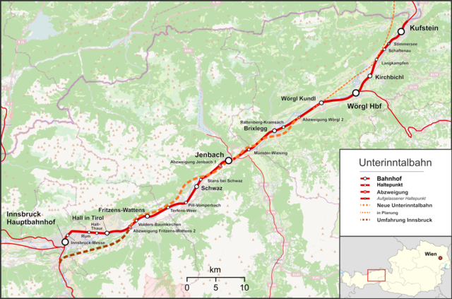
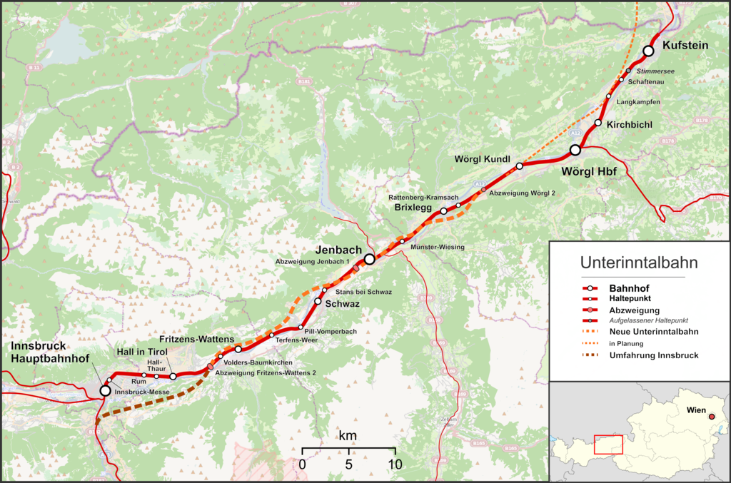
ファイル:Bahnstrecke Kufstein–Innsbruck.png

このプレビューのサイズ: 800 × 529 ピクセル。 その他の解像度: 320 × 212 ピクセル | 640 × 423 ピクセル | 1,024 × 677 ピクセル | 1,280 × 847 ピクセル | 2,560 × 1,693 ピクセル | 4,079 × 2,698 ピクセル。
元のファイル (4,079 × 2,698 ピクセル、ファイルサイズ: 4.32メガバイト、MIME タイプ: image/png)
ウィキメディア・コモンズのファイルページにある説明を、以下に表示します。
|
概要
| 解説 |
English: Map of Lower Inn Valley Railway
Deutsch: Karte der Unterinntalbahn |
| 日付 | |
| 原典 |
投稿者自身による著作物 Map was created using:
|
| 作者 | |
| 許可 (ファイルの再利用) |
Map data (c) OpenStreetMap (and) contributors, CC-BY-SA |
ライセンス
このファイルはクリエイティブ・コモンズ 表示-継承 2.0 一般ライセンスのもとに利用を許諾されています。
- あなたは以下の条件に従う場合に限り、自由に
- 共有 – 本作品を複製、頒布、展示、実演できます。
- 再構成 – 二次的著作物を作成できます。
- あなたの従うべき条件は以下の通りです。
- 表示 – あなたは適切なクレジットを表示し、ライセンスへのリンクを提供し、変更があったらその旨を示さなければなりません。これらは合理的であればどのような方法で行っても構いませんが、許諾者があなたやあなたの利用行為を支持していると示唆するような方法は除きます。
- 継承 – もしあなたがこの作品をリミックスしたり、改変したり、加工した場合には、あなたはあなたの貢献部分を元の作品とこれと同一または互換性があるライセンスの下に頒布しなければなりません。
ファイルの履歴
過去の版のファイルを表示するには、その版の日時をクリックしてください。
| 日付と時刻 | サムネイル | 寸法 | 利用者 | コメント | |
|---|---|---|---|---|---|
| 現在の版 | 2022年4月20日 (水) 11:28 | | 4,079 × 2,698 (4.32メガバイト) | Pechristener | sorry, wrong file was uploaded |
| 2022年4月20日 (水) 11:27 |  | 4,920 × 3,952 (4.44メガバイト) | Pechristener | zwei neue Haltestellen hinzu | |
| 2017年1月16日 (月) 23:07 |  | 4,351 × 2,878 (3.44メガバイト) | Pechristener | Schreibfehler "Umfahrung Insbruck" entfernt | |
| 2013年8月11日 (日) 06:26 |  | 4,351 × 2,878 (3.44メガバイト) | Pechristener | Masstab korr, Salzburg Tiroler Bahn hinzu, Zillertalbahn und Achenseebahn hinzu, erg SFS in Rtg Brannenburg | |
| 2013年8月11日 (日) 05:49 |  | 4,351 × 2,878 (3.31メガバイト) | Pechristener | == {{int:filedesc}} == {{Information |Description ={{en|1=Map of en:Lower Inn Valley Railway}} {{de|1=Karte der Unterinntalbahn }} |Source ={{own}} Map was created using: *[http://www.openstreetmap.org Open... |
ファイルの使用状況
以下のページがこのファイルを使用しています:
グローバルなファイル使用状況
以下に挙げる他のウィキがこの画像を使っています:
- de.wikipedia.org での使用状況
- en.wikipedia.org での使用状況
- hu.wikipedia.org での使用状況
- it.wikipedia.org での使用状況
- www.wikidata.org での使用状況
- zh.wikipedia.org での使用状況