ファイル:Britishindia1855.jpg
このプレビューのサイズ: 492 × 599 ピクセル。 その他の解像度: 197 × 240 ピクセル | 504 × 614 ピクセル。
元のファイル (504 × 614 ピクセル、ファイルサイズ: 343キロバイト、MIME タイプ: image/jpeg)
ウィキメディア・コモンズのファイルページにある説明を、以下に表示します。
|
概要
| 解説 |
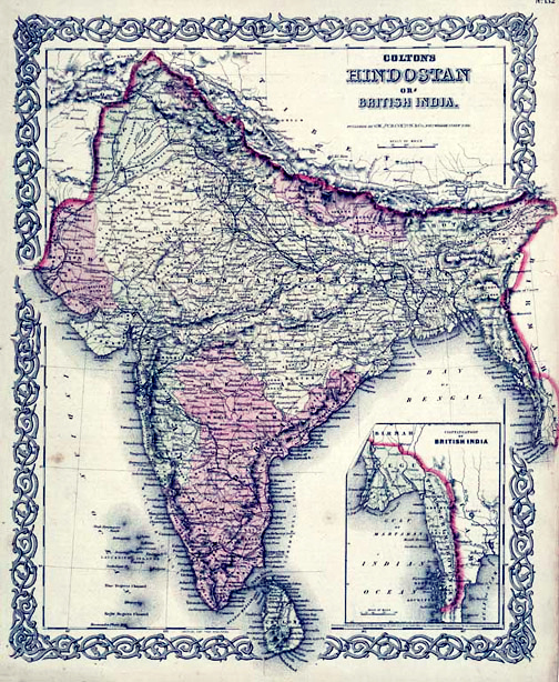
English: Map of British India, 1855. Published by G. W. and C. B. Colton and Company in New York, 1855. It was derived from an earlier wall map of the world produced by Colton and D. Griffing Johnson. Covers the subcontinent from Tibet to Ceylon (Sri Lanka). The map is divided into Bombay, Scinde, Punjab, Nepal, Bhutan, the Bengal Presidency, Madras and Ceylon. An inset map in the lower right quadrant shows British claims in Burma (Pegu) and Southeast Asia. |
| 日付 | |
| 原典 | https://www.geographicus.com/P/AntiqueMap/India-colton-1856 |
| 作者 | Joseph Hutchins Colton (1800-1893) |
元のアップロードログ
元のファイルページはこちら。以下の利用者は全てen.wikipediaに属します。
- This was uploaded by me and Azhar Sayed, and comes from our collection. Mrlopez2681 12:32, 28 December 2006 (UTC)
- 2006-12-28 12:32 Mrlopez2681 504×614×8 (156806 bytes) Map of British India, 1855. Published by G. W. and C. B. Colton and Company in New York, 1855. This was uploaded by me, and comes from my collection. ~~~~
ライセンス
|
パブリックドメインの状態にある著作物をウィキメディア・コモンズに置くためには、アメリカ合衆国と著作物の本国の双方において著作権の保護期間が満了している必要があります。この著作物がアメリカ合衆国のものでない場合には、ファイルに対してその本国における著作権状況を示す著作権タグを付加する必要があります。
|
ファイルの履歴
過去の版のファイルを表示するには、その版の日時をクリックしてください。
| 日付と時刻 | サムネイル | 寸法 | 利用者 | コメント | |
|---|---|---|---|---|---|
| 現在の版 | 2012年9月11日 (火) 12:12 | | 504 × 614 (343キロバイト) | Yann | white balance, contrast, color corrections |
| 2007年12月26日 (水) 15:37 |  | 504 × 614 (153キロバイト) | Andronicus92 | {{Information |Description={{en|Map of British India, 1855. Published by G. W. and C. B. Colton and Company in New York, 1855. This was uploaded by me and Azhar Sayed, and comes from our collection. Mrlopez2681 12:32, 28 December |
ファイルの使用状況
このファイルを使用しているページはありません。
グローバルなファイル使用状況
以下に挙げる他のウィキがこの画像を使っています:
- en.wikipedia.org での使用状況
- ml.wikipedia.org での使用状況
- ro.wikipedia.org での使用状況