ファイル:Carte du Mitanni.png

このプレビューのサイズ: 800 × 534 ピクセル。 その他の解像度: 320 × 214 ピクセル | 640 × 427 ピクセル | 1,024 × 683 ピクセル | 1,272 × 849 ピクセル。
元のファイル (1,272 × 849 ピクセル、ファイルサイズ: 1.51メガバイト、MIME タイプ: image/png)
ウィキメディア・コモンズのファイルページにある説明を、以下に表示します。
|
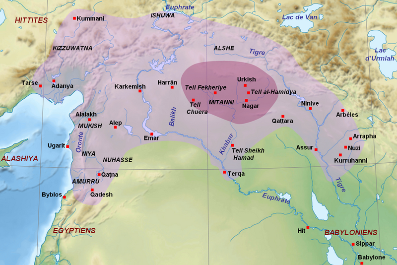
| 解説 |
English: Map of the kingdom of Mitanni at its maximal extension, with the main cities and archaeological sites. Adapted from F. Joannès (dir.), Dictionnaire de la civilisation mésopotamienne, Paris, 2001, p. 534 (map by M. Sauvage and B. Lion), and M. Roaf, Cultural Atlas of Mesopotamia and the Ancient Near East, Oxford, 2004, p. 134 with the addition of Terqa among the vassals of Mitanni. Dark purple : the mitannian heartland ; light purple : the approximate maximal extension of the mitannian dominion.
Français : Carte du royaume du Mitanni avec ses limites approximatives à son apogée avec les principales villes et sites archéologiques. Adapté de F. Joannès (dir.), Dictionnaire de la civilisation mésopotamienne, Paris, 2001, p. 534 (carte de M. Sauvage et B. Lion), et M. Roaf, Cultural Atlas of Mesopotamia and the Ancient Near East, Oxford, 2004, p. 134, avec l'ajout de Terqa parmi les vassaux du Mitanni. Mauve foncé : le cœur du Mitanni ; mauve clair : les limites approximatives de l'extension maximale de la domination du Mitanni au début du XVe siècle av. J.-C. |
| 日付 | (UTC) |
| 原典 | |
| 作者 |
|
| その他のバージョン |
[]
|


この画像には画像編集が施されています。原本に対して次のデジタル的な変更が行われました。
|
この作品の著作権者である私は、この作品を以下のライセンスで提供します。
- あなたは以下の条件に従う場合に限り、自由に
- 共有 – 本作品を複製、頒布、展示、実演できます。
- 再構成 – 二次的著作物を作成できます。
- あなたの従うべき条件は以下の通りです。
- 表示 – あなたは適切なクレジットを表示し、ライセンスへのリンクを提供し、変更があったらその旨を示さなければなりません。これらは合理的であればどのような方法で行っても構いませんが、許諾者があなたやあなたの利用行為を支持していると示唆するような方法は除きます。
- 継承 – もしあなたがこの作品をリミックスしたり、改変したり、加工した場合には、あなたはあなたの貢献部分を元の作品とこれと同一または互換性があるライセンスの下に頒布しなければなりません。

|
この文書は、フリーソフトウェア財団発行のGNUフリー文書利用許諾書 (GNU Free Documentation License) 1.2またはそれ以降のバージョンの規約に基づき、複製や再配布、改変が許可されます。不可変更部分、表紙、背表紙はありません。このライセンスの複製は、GNUフリー文書利用許諾書という章に含まれています。 |
あなたは上記のライセンスから、どれか一つ以上を選択できます。
元のアップロードログ
This image is a derivative work of the following images:
- File:Near_East_topographic_map-blank.svg licensed with Cc-by-sa-3.0,2.5,2.0,1.0, GFDL
- 2009-08-18T18:31:37Z Sémhur 2425x1581 (2442670 Bytes) 3 - New try
- 2009-08-17T15:39:22Z Sémhur 2425x1581 (1815374 Bytes) 2 - With the background...
- 2009-08-17T15:37:36Z Sémhur 2425x1581 (2836 Bytes) {{Information |Description={{en|1=Blank physical map of the [[:en:Near East|Near East]]}} {{fr|1=Carte physique vierge du [[:fr:Proche-Orient|Proche-Orient]].}} |Source={{own}} |Author=[[User:Sémhur|Sémhur]] |Date=2008-08-1
Uploaded with derivativeFX
ファイルの履歴
過去の版のファイルを表示するには、その版の日時をクリックしてください。
| 日付と時刻 | サムネイル | 寸法 | 利用者 | コメント | |
|---|---|---|---|---|---|
| 現在の版 | 2010年9月23日 (木) 14:00 | | 1,272 × 849 (1.51メガバイト) | Zunkir | Ajout de Qattara, corrections mineures. |
| 2010年9月23日 (木) 13:57 |  | 1,272 × 849 (1.51メガバイト) | Zunkir | Coloriage de l'extension du Mitanni, et de sa région centrale, ajout de villes et des noms des cours d'eau. | |
| 2010年9月21日 (火) 11:49 |  | 1,173 × 797 (1.42メガバイト) | Zunkir | {{Information |Description={{en|1=Map of the kingdom of Mitanni at its maximal extension, with the main cities and archeological sites.}} {{fr|Carte du royaume du Mitanni à son apogée avec les principales villes et sites archéologiques.}} |Source=*[[: |
ファイルの使用状況
グローバルなファイル使用状況
以下に挙げる他のウィキがこの画像を使っています:
- am.wikipedia.org での使用状況
- ar.wikipedia.org での使用状況
- arz.wikipedia.org での使用状況
- ast.wikipedia.org での使用状況
- ba.wikipedia.org での使用状況
- be-tarask.wikipedia.org での使用状況
- bg.wikipedia.org での使用状況
- bn.wikipedia.org での使用状況
- br.wikipedia.org での使用状況
- ceb.wikipedia.org での使用状況
- ckb.wikipedia.org での使用状況
- cs.wikipedia.org での使用状況
- de.wikipedia.org での使用状況
- el.wikipedia.org での使用状況
- en.wikipedia.org での使用状況
- eo.wikipedia.org での使用状況
- fa.wikipedia.org での使用状況
- fi.wikipedia.org での使用状況
- fr.wikipedia.org での使用状況
- gl.wikipedia.org での使用状況
- hi.wikipedia.org での使用状況
- id.wikipedia.org での使用状況
- it.wikipedia.org での使用状況
- lt.wikipedia.org での使用状況
- lv.wikipedia.org での使用状況
- ne.wikipedia.org での使用状況
- nl.wikipedia.org での使用状況
- pl.wikipedia.org での使用状況
このファイルのグローバル使用状況を表示する。