ファイル:Comparison azimuthal projections.svg

この SVG ファイルのこの PNG プレビューのサイズ: 512 × 171 ピクセル. その他の解像度: 320 × 107 ピクセル | 640 × 214 ピクセル | 1,024 × 342 ピクセル | 1,280 × 428 ピクセル | 2,560 × 855 ピクセル。
元のファイル (SVG ファイル、512 × 171 ピクセル、ファイルサイズ: 113キロバイト)
ウィキメディア・コモンズのファイルページにある説明を、以下に表示します。
|
概要
| 解説 |
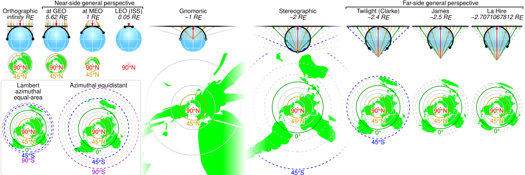
English: Comparison of some azimuthal projections of the world map based on information on http://www.progonos.com/furuti/MapProj/Normal/ProjAz/projAz.html . Values indicated are mean altitudes in terms of Earth radii. Circles denote latitudes of multiples of 15-degrees (dashed lines represent the southern hemisphere). In the SVG file, hover over a circle to show its latitude in a tooltip. |
| 原典 | 投稿者自身による著作物 |
| 作者 | Cmglee |
| SVG 開発 |
ライセンス
この作品の著作権者である私は、この作品を以下のライセンスで提供します。
このファイルはクリエイティブ・コモンズ 表示-継承 3.0 非移植ライセンスのもとに利用を許諾されています。
- あなたは以下の条件に従う場合に限り、自由に
- 共有 – 本作品を複製、頒布、展示、実演できます。
- 再構成 – 二次的著作物を作成できます。
- あなたの従うべき条件は以下の通りです。
- 表示 – あなたは適切なクレジットを表示し、ライセンスへのリンクを提供し、変更があったらその旨を示さなければなりません。これらは合理的であればどのような方法で行っても構いませんが、許諾者があなたやあなたの利用行為を支持していると示唆するような方法は除きます。
- 継承 – もしあなたがこの作品をリミックスしたり、改変したり、加工した場合には、あなたはあなたの貢献部分を元の作品とこれと同一または互換性があるライセンスの下に頒布しなければなりません。

|
この文書は、フリーソフトウェア財団発行のGNUフリー文書利用許諾書 (GNU Free Documentation License) 1.2またはそれ以降のバージョンの規約に基づき、複製や再配布、改変が許可されます。不可変更部分、表紙、背表紙はありません。このライセンスの複製は、GNUフリー文書利用許諾書という章に含まれています。 |
あなたは上記のライセンスから、どれか一つ以上を選択できます。
ファイルの履歴
過去の版のファイルを表示するには、その版の日時をクリックしてください。
| 日付と時刻 | サムネイル | 寸法 | 利用者 | コメント | |
|---|---|---|---|---|---|
| 現在の版 | 2019年6月3日 (月) 00:42 | 512 × 171 (113キロバイト) | Cmglee | Put a box around equal-area and equidistant projections. | |
| 2017年11月6日 (月) 09:09 | 512 × 171 (113キロバイト) | Cmglee | Use <?xml version="1.0" encoding="utf-8"?> instead of <!DOCTYPE svg PUBLIC "-//W3C//DTD SVG 1.1//EN" "http://www.w3.org/Graphics/SVG/1.1/DTD/svg11.dtd"> . | ||
| 2017年11月5日 (日) 09:42 | 512 × 171 (113キロバイト) | Cmglee | Change primary font to Helvetica and restore minus signs as thumbnail generation is broken (degrees appear as "?"). | ||
| 2017年11月5日 (日) 09:40 | 512 × 171 (113キロバイト) | Cmglee | Use plain "-" as en dashes don't appear in thumbnail. | ||
| 2017年11月5日 (日) 09:37 | 512 × 171 (113キロバイト) | Cmglee | Replace minus signs with en dashes as they don't appear in thumbnails. | ||
| 2017年11月5日 (日) 09:32 | 512 × 171 (113キロバイト) | Cmglee | Add map and tooltips. | ||
| 2015年2月27日 (金) 01:25 | 512 × 171 (56キロバイト) | Cmglee | Fix azimuthal equidistant scale and tweak globe and labels. | ||
| 2015年2月25日 (水) 01:06 | 512 × 171 (52キロバイト) | Cmglee | Further increase font size. | ||
| 2015年2月25日 (水) 00:17 | 512 × 171 (52キロバイト) | Cmglee | Fix font size and line width. | ||
| 2015年2月25日 (水) 00:15 | 512 × 171 (52キロバイト) | Cmglee | {{Information |Description ={{en|1=Comparison of some azimuthal projections of the world map based on information on http://www.progonos.com/furuti/MapProj/Normal/ProjAz/projAz.html . Values indicated are mean altitudes in terms of Earth radii. Circ... |
ファイルの使用状況
以下のページがこのファイルを使用しています:
グローバルなファイル使用状況
以下に挙げる他のウィキがこの画像を使っています:
- de.wikipedia.org での使用状況
- en.wikipedia.org での使用状況
- es.wikipedia.org での使用状況
- fi.wikipedia.org での使用状況
- zh.wikipedia.org での使用状況