ファイル:Compass rose.png
高解像度版はありません。
Compass_rose.png (340 × 345 ピクセル、ファイルサイズ: 72キロバイト、MIME タイプ: image/png)
ウィキメディア・コモンズのファイルページにある説明を、以下に表示します。
|
概要
| 解説 |
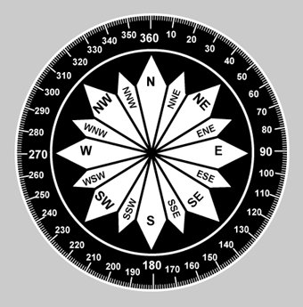
English: By using the meridians, direction from one point to another can be measured in degrees, in a clockwise direction from true north. To indicate a course to be followed in flight, draw a line on the chart from the point of departure to the destination and measure the angle which this line forms with a meridian. Direction is expressed in degrees, as shown by the compass rose |
| 原典 | Fig 08-04, Advisory Circular AC 61-23C, Pilot's Handbook of Aeronautical Knowledge, U.S. en:Federal Aviation Administration, Revised 1997. |
| 作者 | Someone at the US FAA |

|
このグラフ画像は、ベクターイメージである SVG ファイルとして再作成されるべきです。これにはいくつかの利点があります。詳しくはCommons:Media for cleanupを参照してください。この画像の SVG 形式がすでに利用可能である場合は、アップロードしてください。アップロード後、この画像にあるこのテンプレートを{{Vector version available|新しい画像ファイル名.svg}}テンプレートで置き換えてください。
|
ライセンス
This image or file is a work of a Federal Aviation Administration employee, taken or made as part of that person's official duties. As a work of the U.S. federal government, the image is in the public domain in the United States.
|
 |
元のアップロードログ
元のファイルページはこちら。以下の利用者は全てen.wikipediaに属します。
- 2007-01-21 01:52 Dhaluza 340×345×8 (74028 bytes) By using the meridians, direction from one point to another can be measured in degrees, in a clockwise direction from true north. To indicate a course to be followed in flight, draw a line on the chart from the point of departure to the destination and me
ファイルの履歴
過去の版のファイルを表示するには、その版の日時をクリックしてください。
| 日付と時刻 | サムネイル | 寸法 | 利用者 | コメント | |
|---|---|---|---|---|---|
| 現在の版 | 2007年11月30日 (金) 03:08 | | 340 × 345 (72キロバイト) | File Upload Bot (Magnus Manske) | {{BotMoveToCommons|en.wikipedia}} {{Information |Description={{en|By using the meridians, direction from one point to another can be measured in degrees, in a clockwise direction from true north. To indicate a course to be followed in flight, draw a line |
ファイルの使用状況
以下のページがこのファイルを使用しています:
グローバルなファイル使用状況
以下に挙げる他のウィキがこの画像を使っています:
- en.wikibooks.org での使用状況
- th.wikipedia.org での使用状況