ファイル:Grossdeutsches Reich NS Administration 1944.png
元のファイル (2,615 × 2,030 ピクセル、ファイルサイズ: 250キロバイト、MIME タイプ: image/png)
ウィキメディア・コモンズのファイルページにある説明を、以下に表示します。
|
概要
| 解説 |
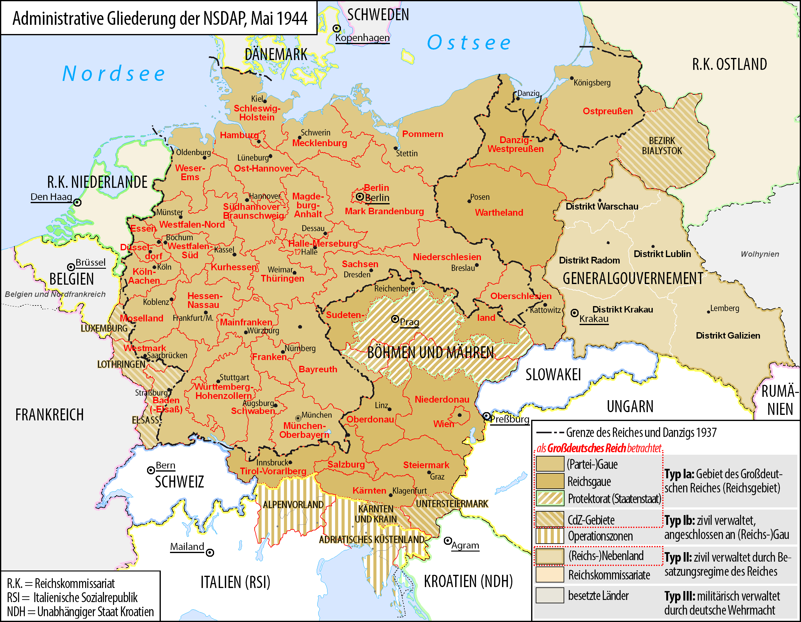
Deutsch: Karte der administrativen Gliederung des Großdeutschen Reiches durch die NSDAP 1944.
English: Map of the administrative division of the Greater German Reich ("Großdeutsches Reich"/"Großdeutschland"/"Greater German Empire"/"Greater Germany") by the NSDAP 1944 (in German).
Polski: Mapa Wielkiej Rzeszy Niemieckiej (1944) |
||
| 日付 | |||
| 原典 | 投稿者自身による著作物 | ||
| 作者 | Bennet Schulte | ||
| 許可 (ファイルの再利用) |
|
||
| その他のバージョン |
|


ライセンス
- あなたは以下の条件に従う場合に限り、自由に
- 共有 – 本作品を複製、頒布、展示、実演できます。
- 再構成 – 二次的著作物を作成できます。
- あなたの従うべき条件は以下の通りです。
- 表示 – あなたは適切なクレジットを表示し、ライセンスへのリンクを提供し、変更があったらその旨を示さなければなりません。これらは合理的であればどのような方法で行っても構いませんが、許諾者があなたやあなたの利用行為を支持していると示唆するような方法は除きます。
- 継承 – もしあなたがこの作品をリミックスしたり、改変したり、加工した場合には、あなたはあなたの貢献部分を元の作品とこれと同一または互換性があるライセンスの下に頒布しなければなりません。

|
この文書は、フリーソフトウェア財団発行のGNUフリー文書利用許諾書 (GNU Free Documentation License) 1.2またはそれ以降のバージョンの規約に基づき、複製や再配布、改変が許可されます。不可変更部分、表紙、背表紙はありません。このライセンスの複製は、GNUフリー文書利用許諾書という章に含まれています。 |
ファイルの履歴
過去の版のファイルを表示するには、その版の日時をクリックしてください。
| 日付と時刻 | サムネイル | 寸法 | 利用者 | コメント | |
|---|---|---|---|---|---|
| 現在の版 | 2017年6月3日 (土) 05:23 | | 2,615 × 2,030 (250キロバイト) | Exec | auf vielfachen Wunsch wurden die zum Zeitpunkt der Darstellung existierenden militärisch verwalteten Gebiete "Wolhynien" (Rest von RK Ukraine) sowie "Belgien und Nordfrankreich" beschriftet und abgegrenzt wenn abweichend von Staatsgrenzen |
| 2016年2月4日 (木) 00:26 |  | 2,615 × 2,030 (344キロバイト) | Exec | Reverted to version as of 10:37, 11 September 2015 (UTC): thematic content don't include military administative units, see https://commons.wikimedia.org/wiki/File_talk:Greater_German_Reich_NS_Administration_1944.png#Problems_with_the_map | |
| 2015年12月6日 (日) 15:04 |  | 2,607 × 2,022 (579キロバイト) | Braganza | Reverted to version as of 22:32, 7 July 2014 (UTC) | |
| 2015年9月11日 (金) 10:37 |  | 2,615 × 2,030 (344キロバイト) | RokerHRO | optipng -i0 -zc1-9 -zm1-9 -zs0-3 -f0-5 -i0 → 35.13% decrease | |
| 2015年6月27日 (土) 09:32 |  | 2,615 × 2,030 (530キロバイト) | Exec | - clearified phrase for dotted line (statt "dargestellt als", "als betrachtet" | |
| 2015年6月27日 (土) 09:23 |  | 2,616 × 2,029 (530キロバイト) | Exec | - added subdevision of the Operationszonen - fixed explanation of red dotted line (visualisation in cartographic materials as Großdeutsches Reich) and exclude Operationszonen | |
| 2015年4月3日 (金) 00:18 |  | 2,607 × 2,022 (231キロバイト) | Exec | Reverted to version as of 21:17, 17 July 2014 because no fixes are identified but some black objects are switched to grey with out logic and benefit.undaries to grey | |
| 2015年3月29日 (日) 07:08 |  | 2,607 × 2,022 (345キロバイト) | DIREKTOR | Small fix. | |
| 2014年7月17日 (木) 21:17 |  | 2,607 × 2,022 (231キロバイト) | Execger | Boundaries of millitary administration is not part of the thematic content. | |
| 2014年7月7日 (月) 22:32 |  | 2,607 × 2,022 (579キロバイト) | Victor falk~commonswiki | belgien und nordfrankreich |
ファイルの使用状況
以下の 4 ページがこのファイルを使用しています:
グローバルなファイル使用状況
以下に挙げる他のウィキがこの画像を使っています:
- cs.wikipedia.org での使用状況
- da.wikipedia.org での使用状況
- de.wikipedia.org での使用状況
- Gau
- Geschichte Österreichs
- Generalgouvernement
- Beneš-Dekrete
- Reichsstatthalter
- Reichsgau
- Danzig-Westpreußen
- Deutsche Frage
- Geschichte der Steiermark
- Kriegsschauplatz Mittelmeerraum
- NS-Staat
- Diskussion:Liste der größten deutschen Städte
- Liste der Wappen in Deutschland
- Geschichte Niederösterreichs
- Deutschland
- Operationszone Adriatisches Küstenland
- Diskussion:Deutschland/Archiv/2
- Geschichte Oberösterreichs
- Ostmarkgesetz
- Portal Diskussion:Nationalsozialismus/Archiv/2010
- Liste der Postleitregionen in Deutschland
- Wikipedia:Kartenwerkstatt/Archiv/Zurückgewiesene und zurückgestellte Aufträge 2012
- Portal Diskussion:Nationalsozialismus/Archiv/2014
- Diskussion:Uschi Nerke
- Wikipedia:Redaktion Geschichte/Archiv/2023/Feb
- frr.wikipedia.org での使用状況
- fr.wikipedia.org での使用状況
- fr.wiktionary.org での使用状況
- gl.wikipedia.org での使用状況
- hak.wikipedia.org での使用状況
- he.wikipedia.org での使用状況
- it.wikipedia.org での使用状況
- lb.wikipedia.org での使用状況
- lld.wikipedia.org での使用状況
- lt.wikipedia.org での使用状況
- nl.wikipedia.org での使用状況
このファイルのグローバル使用状況を表示する。