ファイル:IntertropicalConvergenceZone-EO.jpg

元のファイル (2,772 × 1,250 ピクセル、ファイルサイズ: 1.54メガバイト、MIME タイプ: image/jpeg)
ウィキメディア・コモンズのファイルページにある説明を、以下に表示します。
|
概要
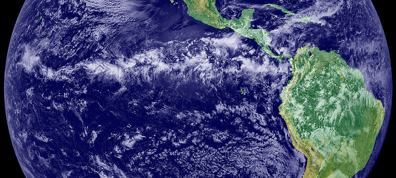
The Intertropical Convergence Zone (ITCZ), is the region that circles the Earth, near the equator, where the trade winds of the Northern and Southern Hemispheres come together. The intense sun and warm water of the equator heats the air in the ITCZ, raising its humidity and causing it to rise. As the air rises it cools, releasing the accumulated moisture in an almost perpetual series of thunderstorms.
Variation in the location of the ITCZ drastically affects rainfall in many equatorial nations, resulting in the wet and dry seasons of the tropics rather than the cold and warm seasons of higher latitudes. Longer term changes in the ITCZ can result in severe droughts or flooding in nearby areas.
Credit/source
This image is a combination of cloud data from NOAA’s newest Geostationary Operational Environmental Satellite (GOES-11) and color land cover classification data. The ITCZ is the band of bright white clouds that cuts across the center of the image.
http://earthobservatory.nasa.gov/IOTD/view.php?id=703
ライセンス
| このファイルはアメリカ航空宇宙局(NASA)によって作成されたものです。NASAの著作権の方針では、特記事項が無い場合、NASAの資料はパブリックドメインとなります。 (詳しくはTemplate:PD-USGov、NASAの著作権の方針について(英語)又はジェット推進研究所(JPL)の画像使用に関するガイドライン(英語)をご覧ください。) |
||
 |
注意事項:
|
ファイルの履歴
過去の版のファイルを表示するには、その版の日時をクリックしてください。
| 日付と時刻 | サムネイル | 寸法 | 利用者 | コメント | |
|---|---|---|---|---|---|
| 現在の版 | 2005年6月12日 (日) 17:45 | | 2,772 × 1,250 (1.54メガバイト) | Gustavo Carrancio~commonswiki | Pic from http://earthobservatory.nasa.gov/Newsroom/NewImages/images.php3?img_id=4028 File history Nasa photo with no especific Copyright |
ファイルの使用状況
以下のページがこのファイルを使用しています:
グローバルなファイル使用状況
以下に挙げる他のウィキがこの画像を使っています:
- bh.wikipedia.org での使用状況
- bn.wikipedia.org での使用状況
- ca.wikipedia.org での使用状況
- cs.wikipedia.org での使用状況
- da.wikipedia.org での使用状況
- de.wikipedia.org での使用状況
- el.wikipedia.org での使用状況
- en.wikipedia.org での使用状況
- en.wikibooks.org での使用状況
- en.wikiversity.org での使用状況
- en.wiktionary.org での使用状況
- es.wikipedia.org での使用状況
- fa.wikipedia.org での使用状況
- fi.wikipedia.org での使用状況
- fr.wikipedia.org での使用状況
- fr.wikinews.org での使用状況
- ga.wikipedia.org での使用状況
- ha.wikipedia.org での使用状況
- he.wikipedia.org での使用状況
- hi.wikipedia.org での使用状況
- id.wikipedia.org での使用状況
- ig.wikipedia.org での使用状況
- ko.wikipedia.org での使用状況
- ko.wiktionary.org での使用状況
- mk.wikipedia.org での使用状況
- nl.wikipedia.org での使用状況
- nn.wikipedia.org での使用状況
- no.wikipedia.org での使用状況
- oc.wikipedia.org での使用状況
- pap.wikipedia.org での使用状況
このファイルのグローバル使用状況を表示する。