ファイル:Islamist insurgency in Nigeria.svg

元のファイル (SVG ファイル、254 × 254 ピクセル、ファイルサイズ: 412キロバイト)
ウィキメディア・コモンズのファイルページにある説明を、以下に表示します。
|
概要
Notice by the original uploader
Please help improving this file. I need your elaborate help. I made it because there had not been any images explaining the insurgency while maps showing the islamic state in iraq and sham exists.
| 解説 |
Español: Insurgencia islámica en Nigeria green - Nigeria |
||||
| 日付 | |||||
| 原典 | 投稿者自身による著作物, adapted from File:Nigeria - Location Map (2013) - NGA - UNOCHA.svg | ||||
| 作者 | 햄방이 | ||||
| その他のバージョン |
|


.svg)

.png)


.svg)


.svg)


_Territory_Change_2014-2016.gif)

_(within_Northern_Syria).svg)


.png)
.svg)


_map.png)
.svg)


.svg)


_-_NGA_-_UNOCHA.svg)
References
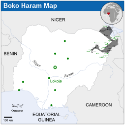
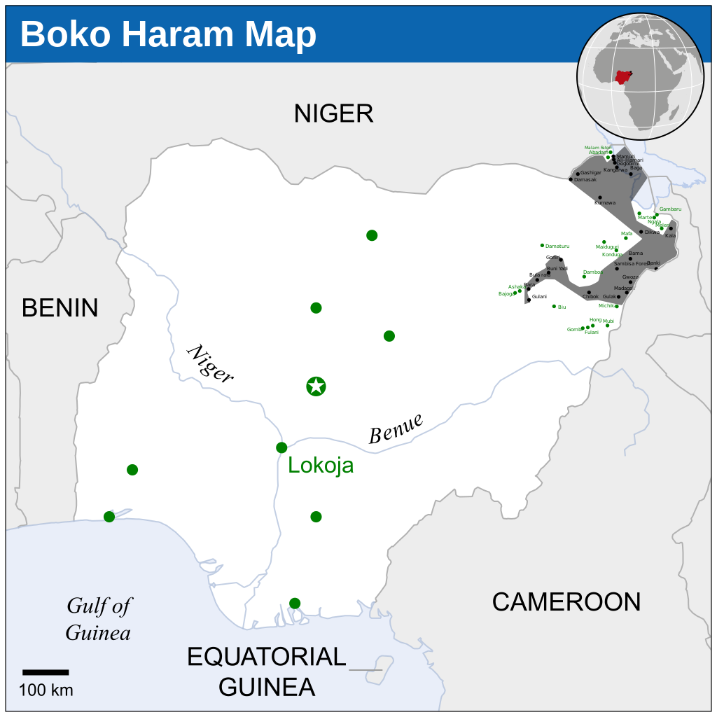
- 1 - Gwoza, Damask, Bama, Gamboru-Ngala, Dikwa, Mafa under boko haram control (Dec 13, 2014)
- 2 - Bama, Gwoza, Madagali, Gulak, Shuwa, Michika under boko haram control (November 21, 2014)
- 3 - Buni Yadi, Gujba, Gulani, Kukuwa, Bularafa, Buni Gari, Bara, Bumsa, Taltaba under boko haram control (November 23, 2014)
- 4 - 41 DAYS TO ELECTIONS: 13 Local Govts under Boko Haram
Nine of the affected local governments are in Borno State and they are: Gwoza, Bama, Mafa, Dikwa, Kala-Balge, Ngala, Marte, Abadam and Mobbar. The other four are Michika and Madagali in Adamawa State, as well as Gujba and Gulani in Yobe State.
The insurgents have also established partial control in parts of some local government areas in Borno, comprising Mungono, Kukawa, Guzamala, Gubio, Magumeri, Damboa, konduga, Chibok, Askira Uba and Jere.
Before the outright takeover of many communities in Borno, Adamawa and Yobe states, the Boko Haram had earlier caused collateral damage in various places where they destroyed entire villages, markets, military barracks, police stations, governmental buildings, prisons, farmlands and other symbols of authority and worship places, including churches and mosques,.( 04 January 2015 05:01)
In February 2015, Chadian Army retook Gamboru, Malam Fatori, Marte and Nigerian Army retook Michika, Mafa.
ライセンス
- あなたは以下の条件に従う場合に限り、自由に
- 共有 – 本作品を複製、頒布、展示、実演できます。
- 再構成 – 二次的著作物を作成できます。
- あなたの従うべき条件は以下の通りです。
- 表示 – あなたは適切なクレジットを表示し、ライセンスへのリンクを提供し、変更があったらその旨を示さなければなりません。これらは合理的であればどのような方法で行っても構いませんが、許諾者があなたやあなたの利用行為を支持していると示唆するような方法は除きます。
- 継承 – もしあなたがこの作品をリミックスしたり、改変したり、加工した場合には、あなたはあなたの貢献部分を元の作品とこれと同一または互換性があるライセンスの下に頒布しなければなりません。
ファイルの履歴
過去の版のファイルを表示するには、その版の日時をクリックしてください。
| 日付と時刻 | サムネイル | 寸法 | 利用者 | コメント | |
|---|---|---|---|---|---|
| 現在の版 | 2022年11月19日 (土) 02:44 | | 254 × 254 (412キロバイト) | Pengetik-AM | File uploaded using svgtranslate tool (https://svgtranslate.toolforge.org/). Added translation for id. |
| 2015年2月21日 (土) 06:00 |  | 254 × 254 (405キロバイト) | 햄방이 | Chad attacked Boko Haram and retook some villages | |
| 2015年1月10日 (土) 13:09 |  | 254 × 254 (405キロバイト) | 햄방이 | Simplify | |
| 2015年1月10日 (土) 11:44 |  | 254 × 254 (420キロバイト) | 햄방이 | Added texts | |
| 2015年1月10日 (土) 11:29 |  | 254 × 254 (413キロバイト) | 햄방이 | http://allafrica.com/stories/201411102298.html malam fatori into boko haram. I didn't know that. My mistake | |
| 2015年1月8日 (木) 18:48 |  | 254 × 254 (383キロバイト) | Jurryaany | Added Baga town. | |
| 2015年1月3日 (土) 17:13 |  | 254 × 254 (382キロバイト) | Jurryaany | Removed OCHA mark | |
| 2014年12月20日 (土) 03:27 |  | 254 × 254 (434キロバイト) | 햄방이 | more complicated | |
| 2014年11月29日 (土) 16:48 |  | 254 × 254 (410キロバイト) | 햄방이 | User created page with UploadWizard |
ファイルの使用状況
以下のページがこのファイルを使用しています:
グローバルなファイル使用状況
以下に挙げる他のウィキがこの画像を使っています:
- ast.wikipedia.org での使用状況
- br.wikipedia.org での使用状況
- et.wikipedia.org での使用状況
- fr.wikipedia.org での使用状況
- he.wikipedia.org での使用状況
- ko.wikipedia.org での使用状況
- pt.wikipedia.org での使用状況
- uk.wikipedia.org での使用状況