ファイル:Juba map.jpg
高解像度版はありません。
Juba_map.jpg (519 × 533 ピクセル、ファイルサイズ: 67キロバイト、MIME タイプ: image/jpeg)
ウィキメディア・コモンズのファイルページにある説明を、以下に表示します。
|
| 解説 |
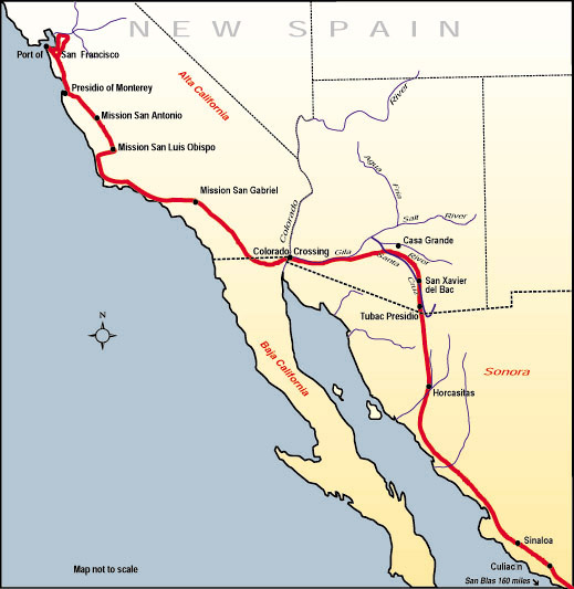
English: Map of the route, Juan Bautista de Anza travelled in 1775-76 from Mexico to todays San Francisco, where he founded the Presidio of San Francisco. Español: Mapa de la ruta que Juan Bautista de Anza recorrió en 1775-76 desde México hasta la actual San Francisco, donde fundó el Presidio de San Francisco. |
|||
| 原典 | http://www.nps.gov/juba | |||
| 作者 | ||||
| 許可 (ファイルの再利用) |
|
ファイルの履歴
過去の版のファイルを表示するには、その版の日時をクリックしてください。
| 日付と時刻 | サムネイル | 寸法 | 利用者 | コメント | |
|---|---|---|---|---|---|
| 現在の版 | 2006年7月10日 (月) 20:53 | | 519 × 533 (67キロバイト) | H-stt | {{Information |Description= Map of the route, Juan Bautista de Anza travelled in 1775-76 from Baja California to todays San Francisco, where he founded the Presidio of San Francisco |Source= http://www.nps.gov/juba |Date= |Author= |Permission= {{PD-USGov |
ファイルの使用状況
以下のページがこのファイルを使用しています:
グローバルなファイル使用状況
以下に挙げる他のウィキがこの画像を使っています:
- bg.wikipedia.org での使用状況
- ca.wikipedia.org での使用状況
- en.wikipedia.org での使用状況
- es.wikipedia.org での使用状況
- hy.wikipedia.org での使用状況