ファイル:Kentucky Bend map.png
このプレビューのサイズ: 600 × 600 ピクセル。 その他の解像度: 240 × 240 ピクセル | 480 × 480 ピクセル | 720 × 720 ピクセル。
元のファイル (720 × 720 ピクセル、ファイルサイズ: 31キロバイト、MIME タイプ: image/png)
ウィキメディア・コモンズのファイルページにある説明を、以下に表示します。
|
概要
| 解説 | |
| 日付 | |
| 原典 | self; based on US Census TIGER generated map image |
| 作者 | Jim Efaw (self) |
| 許可 (ファイルの再利用) |
CC-By-SA for overlay; original map is public domain US government work |
| その他のバージョン | Image:Kentucky Bend.png |
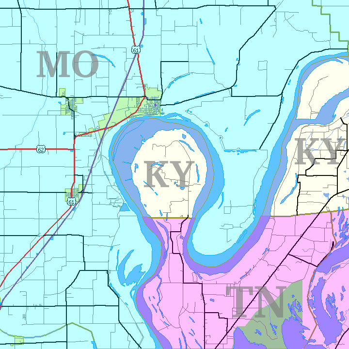
English: This is a map of the Kentucky Bend, the southwest corner of Fulton County, Kentucky that was separated from the rest of the state by the change in the Mississippi River from the New Madrid earthquakes. Based on United States Census TIGER Map output. Color and state abbreviation overlays created using The Gimp; optimized using pngnq and PNGOUT. 720×720, 32 color 8-bit palette.
ライセンス
この作品の著作権者であるJim Efaw, author of this workは、この作品を以下のライセンスで提供しています。
帰属: Jim Efaw, author of this work
- あなたは以下の条件に従う場合に限り、自由に
- 共有 – 本作品を複製、頒布、展示、実演できます。
- 再構成 – 二次的著作物を作成できます。
- あなたの従うべき条件は以下の通りです。
- 表示 – あなたは適切なクレジットを表示し、ライセンスへのリンクを提供し、変更があったらその旨を示さなければなりません。これらは合理的であればどのような方法で行っても構いませんが、許諾者があなたやあなたの利用行為を支持していると示唆するような方法は除きます。
- 継承 – もしあなたがこの作品をリミックスしたり、改変したり、加工した場合には、あなたはあなたの貢献部分を元の作品とこれと同一または互換性があるライセンスの下に頒布しなければなりません。
ファイルの履歴
過去の版のファイルを表示するには、その版の日時をクリックしてください。
| 日付と時刻 | サムネイル | 寸法 | 利用者 | コメント | |
|---|---|---|---|---|---|
| 現在の版 | 2007年1月14日 (日) 05:35 | | 720 × 720 (31キロバイト) | Closeapple | {{Information |Description=Map of Kentucky Bend w:exclave between Missouri and Tennessee, USA. |Source=self; based on [http://tiger.census.gov/cgi-bin/mapper/map.gif?&lat=39.74099&lon=-89.07248&ht=6.000&wid=5.000&on=CITIES&on=shorelin&on=states&on |
ファイルの使用状況
以下のページがこのファイルを使用しています:
グローバルなファイル使用状況
以下に挙げる他のウィキがこの画像を使っています:
- cs.wikipedia.org での使用状況
- de.wikipedia.org での使用状況
- en.wikipedia.org での使用状況
- es.wikipedia.org での使用状況
- hu.wikipedia.org での使用状況
- ko.wikipedia.org での使用状況
- nl.wikipedia.org での使用状況
- pt.wikipedia.org での使用状況
- ru.wikipedia.org での使用状況
- sv.wikipedia.org での使用状況