ファイル:MH -map A.png

このプレビューのサイズ: 740 × 600 ピクセル。 その他の解像度: 296 × 240 ピクセル | 592 × 480 ピクセル | 950 × 770 ピクセル。
元のファイル (950 × 770 ピクセル、ファイルサイズ: 20キロバイト、MIME タイプ: image/png)
ウィキメディア・コモンズのファイルページにある説明を、以下に表示します。
|

|
このlocator map画像は、ベクターイメージである SVG ファイルとして再作成されるべきです。これにはいくつかの利点があります。詳しくはCommons:Media for cleanupを参照してください。この画像の SVG 形式がすでに利用可能である場合は、アップロードしてください。アップロード後、この画像にあるこのテンプレートを{{Vector version available|新しい画像ファイル名.svg}}テンプレートで置き換えてください。
|
概要
| 解説 |
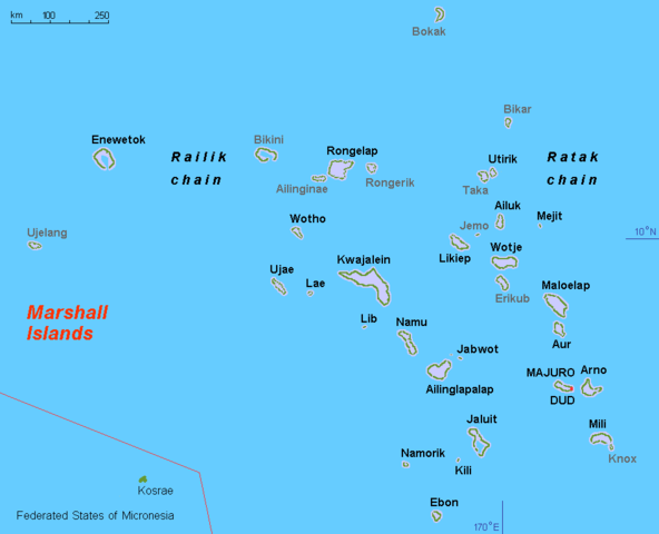
English: Map (rough) Marshall islands, own work composed from various mapreferences |
| 日付 | |
| 原典 | 投稿者自身による著作物 |
| 作者 | Hobe / Holger Behr |
| その他のバージョン |
このファイルの派生的著作物: Operation K Map.jpg
|
ライセンス
| この著作物の著作権者である私は、この著作物における権利を放棄しパブリックドメインとします。これは全世界で適用されます。 一部の国では、これが法的に可能ではない場合があります。その場合は、次のように宣言します。 私は、あらゆる人に対して、法により必要とされている条件を除き、如何なる条件も課すことなく、あらゆる目的のためにこの著作物を使用する権利を与えます。 |
ファイルの履歴
過去の版のファイルを表示するには、その版の日時をクリックしてください。
| 日付と時刻 | サムネイル | 寸法 | 利用者 | コメント | |
|---|---|---|---|---|---|
| 現在の版 | 2010年11月11日 (木) 13:44 | | 950 × 770 (20キロバイト) | Hobe | minor design change, restored origional uploader |
| 2010年9月17日 (金) 04:03 |  | 950 × 775 (31キロバイト) | Lasunncty | uninhabited islands/atolls in grey | |
| 2008年3月19日 (水) 17:59 |  | 950 × 775 (20キロバイト) | Hobe | map (rough) Marshall islands, larger letters Source: self-made, composed from various mapreferences Date 2008-03-13 Author Hobe Category:Maps of the Marshall Islands | |
| 2008年3月16日 (日) 18:27 |  | 950 × 650 (17キロバイト) | Hobe | {{Information |Description=map (rough) Marshall islands |Source=self-made, composed from various mapreferences |Date=2008-03-03 |Author= Hobe |Permission= |other_versions= Category:Maps of the Marshall Islands }} Source |
ファイルの使用状況
グローバルなファイル使用状況
以下に挙げる他のウィキがこの画像を使っています:
- af.wikipedia.org での使用状況
- ami.wikipedia.org での使用状況
- ar.wikipedia.org での使用状況
- ast.wikipedia.org での使用状況
- ba.wikipedia.org での使用状況
- br.wikipedia.org での使用状況
- ca.wikipedia.org での使用状況
- da.wikipedia.org での使用状況
- el.wikipedia.org での使用状況
- en.wikipedia.org での使用状況
- en.wiktionary.org での使用状況
- es.wikipedia.org での使用状況
- eu.wikipedia.org での使用状況
- fa.wikipedia.org での使用状況
- fi.wikipedia.org での使用状況
- fr.wikipedia.org での使用状況
- gl.wikipedia.org での使用状況
このファイルのグローバル使用状況を表示する。