ファイル:Mankato-New Ulm-North Mankato CSA.png
高解像度版はありません。
Mankato-New_Ulm-North_Mankato_CSA.png (440 × 498 ピクセル、ファイルサイズ: 14キロバイト、MIME タイプ: image/png)
ウィキメディア・コモンズのファイルページにある説明を、以下に表示します。
|
概要
| 解説 |
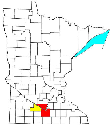
Locator map of the Mankato-New Ulm-North Mankato Combined Statistical Area (CSA) in the southern part of the U.S. state of Minnesota. The two components of the CSA are colored separately: |
| 日付 | |
| 原典 | Modified from this United States Census Bureau file, based on this Census definitions list. |
| 作者 | User:Nyttend, Yassie |
| 許可 (ファイルの再利用) |
US Government work is public domain. Nyttend's work, File:Mankato-North Mankato Micropolitan Area.png, was released into public domain on July 26, 2008. I, Yassie, hereby release my modified work into public domain, too, on January 21, 2019. |
ライセンス
| この著作物の著作権者である私は、この著作物における権利を放棄しパブリックドメインとします。これは全世界で適用されます。 一部の国では、これが法的に可能ではない場合があります。その場合は、次のように宣言します。 私は、あらゆる人に対して、法により必要とされている条件を除き、如何なる条件も課すことなく、あらゆる目的のためにこの著作物を使用する権利を与えます。 |
ファイルの履歴
過去の版のファイルを表示するには、その版の日時をクリックしてください。
| 日付と時刻 | サムネイル | 寸法 | 利用者 | コメント | |
|---|---|---|---|---|---|
| 現在の版 | 2019年1月20日 (日) 15:17 | | 440 × 498 (14キロバイト) | Yassie | {{Information |Description=Locator map of the Mankato-New Ulm-North Mankato Combined Statistical Area (CSA) in the southern part of the {{w|U.S. state}} of {{w|Minnesota}}. The two components of the CSA are colored separately: *{{w|Mankato – North Mankato metropolitan area|Mankato-North Mankato Metropolitan Statistical Area}}: red *{{w|Brown County, Minnesota|New Ulm Micropolitan Statistical Area}}: yellow |Source=Modified from [http://www2.census.gov/geo/maps/general_ref/cousub_outline/cen2k... |
ファイルの使用状況
以下のページがこのファイルを使用しています: