ファイル:Map of Achaemenid Imperial Satraps (English Version).png

元のファイル (3,308 × 1,648 ピクセル、ファイルサイズ: 653キロバイト、MIME タイプ: image/png)
ウィキメディア・コモンズのファイルページにある説明を、以下に表示します。
|
.png?uselang=ja)
.png?uselang=ja)
.png?uselang=ja&action=history)
.png)
概要
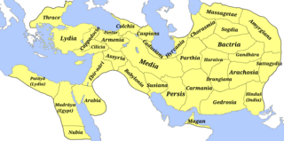
| 解説 | A map of the satraps of the Achaemenid Empire showing their ancient names and the extent of their territory. (Borders are approximate.) | ||
| 日付 | |||
| 原典 |
投稿者自身による著作物
Atlas Antiquus. Atlas zur Geschichte des Altertums. Gotha: Justus Perthes, 1909. (File)
And Design structure and overview: ACHAEMENID SATRAPIES. ENCYCLOPÆDIA IRANICA. Archived from the original on 2022-03-26. Retrieved on 2023-08-15.
File:Map of the Achaemenid Empire.jpg
|
||
| 作者 | M.r ebrahim zadeh | ||
| 許可 (ファイルの再利用) |
|
||
| その他のバージョン |
Fa: Map of Achaemenid Imperial Satraps(fa)
1- File:Bābiruš (Satrapy of the Achaemenid Empire).png |
.png)
.png)
.png)
.png)
.png)
.png)
.png)
.png)
.png)
.png)
.png)
.png)
.png)
.png)
.png)
.png)
.png)
ライセンス
- あなたは以下の条件に従う場合に限り、自由に
- 共有 – 本作品を複製、頒布、展示、実演できます。
- 再構成 – 二次的著作物を作成できます。
- あなたの従うべき条件は以下の通りです。
- 表示 – あなたは適切なクレジットを表示し、ライセンスへのリンクを提供し、変更があったらその旨を示さなければなりません。これらは合理的であればどのような方法で行っても構いませんが、許諾者があなたやあなたの利用行為を支持していると示唆するような方法は除きます。
- 継承 – もしあなたがこの作品をリミックスしたり、改変したり、加工した場合には、あなたはあなたの貢献部分を元の作品とこれと同一または互換性があるライセンスの下に頒布しなければなりません。
- ↑ cartography: Mohammad Pourkamal Drawing maps with the cooperation of selected employees of the drawing department of the organization Mapping and Geography Institute under the supervision of: Ebrahim Khalil Majidian Printing of maps in cooperation with the printing department of the Mapping Organization under the supervision of Shmuel Josephnia Prepared by: Institute of Geography, University of Tehran Persian writings: Mohammad Taghi Sarmast
ファイルの履歴
過去の版のファイルを表示するには、その版の日時をクリックしてください。
| 日付と時刻 | サムネイル | 寸法 | 利用者 | コメント | |
|---|---|---|---|---|---|
| 現在の版 | 2023年8月15日 (火) 09:28 | | 3,308 × 1,648 (653キロバイト) | M.r ebrahim zadeh | Uploaded own work with UploadWizard |
ファイルの使用状況
以下のページがこのファイルを使用しています:
グローバルなファイル使用状況
以下に挙げる他のウィキがこの画像を使っています:
- bs.wikipedia.org での使用状況
- ca.wikipedia.org での使用状況
- en.wikipedia.org での使用状況
- es.wikipedia.org での使用状況
- fa.wikipedia.org での使用状況
- it.wikipedia.org での使用状況
- Frigia
- Paflagonia
- Nubia
- XXVII dinastia egizia
- Cilicia
- Corasmia
- Battriana
- Impero achemenide
- Caria
- Ionia
- Colchide
- Sogdiana
- Aracosia
- Regno di Gandhāra
- Arabia (satrapia)
- Partia
- Libia (satrapia)
- Cappadocia (satrapia)
- Lidia (satrapia)
- Media (satrapia)
- Ircania
- Armenia persiana
- Babilonia (provincia persiana)
- Carmania
- Assiria persiana
- Maka (satrapia)
- Margiana
- Satrapo
- Satrapie achemenidi
- Aria (satrapia)
- Gedrosia
- Drangiana
- Susiana
- Template:Province dell'Impero achemenide
- Sattagidia
- India (satrapia)
- Transeufratene
- ru.wikipedia.org での使用状況
.png)