ファイル:Map of USA highlighting Sun Belt.png
高解像度版はありません。
Map_of_USA_highlighting_Sun_Belt.png (280 × 183 ピクセル、ファイルサイズ: 40キロバイト、MIME タイプ: image/png)
ウィキメディア・コモンズのファイルページにある説明を、以下に表示します。
|
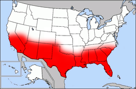
Public domain map courtesy of The General Libraries, The University of Texas at Austin, modified (by • Benc • 00:36, 13 Aug 2004 (UTC) to highlight regions.
Originally uploaded onto English Wikipedia 00:36, 13 August 2004 by Benc
English: This map come from the map collection of University of Texas, specifically from: [{{{url}}} {{{title}}}, from {{{origin}}}]. It is in the public domain (http://www.lib.utexas.edu/maps/faq.html#3.html).
Français : Cette carte est issue issu de la collection de cartes de l'université du Texas et plus précisément de celle-ci : [{{{url}}} {{{title}}}, from {{{origin}}}]. Elle se trouve dans dans le domaine public (http://www.lib.utexas.edu/maps/faq.html#3.html).
Nederlands: Deze afbeelding is afkomstig uit de kaartencollectie van de University of Texas. Deze kaarten bevinden zich in het publiek domein (http://www.lib.utexas.edu/maps/faq.html#3.html).
|
|
この著作物は、著作権の保護期間が著作者の死後70年以下である国・地域においてパブリックドメインの状態にあります。
| |
| このファイルは著作権法の既知の制約(隣接権や関連する権利を含む)から自由であると特定されています。 | |
ファイルの履歴
過去の版のファイルを表示するには、その版の日時をクリックしてください。
| 日付と時刻 | サムネイル | 寸法 | 利用者 | コメント | |
|---|---|---|---|---|---|
| 現在の版 | 2006年9月27日 (水) 17:41 | | 280 × 183 (40キロバイト) | Mr Bullitt~commonswiki | Public domain map courtesy of [http://www.lib.utexas.edu/ The General Libraries, The University of Texas at Austin], modified (by • Benc • 00:36, 13 Aug 2004 (UTC)) to highlight regions. Originally uploaded |
ファイルの使用状況
このファイルを使用しているページはありません。
グローバルなファイル使用状況
以下に挙げる他のウィキがこの画像を使っています:
- en.wikipedia.org での使用状況
- fr.wikipedia.org での使用状況