ファイル:Map of the flooding areas of the Lake Nasser in the Wadi Halfa Salient.png

このプレビューのサイズ: 571 × 600 ピクセル。 その他の解像度: 228 × 240 ピクセル | 457 × 480 ピクセル | 909 × 955 ピクセル。
元のファイル (909 × 955 ピクセル、ファイルサイズ: 1.25メガバイト、MIME タイプ: image/png)
ウィキメディア・コモンズのファイルページにある説明を、以下に表示します。
|
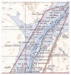
| 解説 |
Deutsch: Überflutungsgebiet des Nasser-Stausees im Wadi Halfa Salient
English: Flooding areas of the Lake Nasser in the Wadi Halfa Salient |
||||||
| 日付 | see file history | ||||||
| 原典 |
own work, using the following files:
|
||||||
| 作者 | Maximilian Dörrbecker (Chumwa) | ||||||
| 許可 (ファイルの再利用) |
この作品の著作権者である私は、この作品を以下のライセンスで提供します。 このファイルはクリエイティブ・コモンズ 表示-継承 2.5 一般ライセンスのもとに利用を許諾されています。
|
||||||
| その他のバージョン |
|


ファイルの履歴
過去の版のファイルを表示するには、その版の日時をクリックしてください。
| 日付と時刻 | サムネイル | 寸法 | 利用者 | コメント | |
|---|---|---|---|---|---|
| 現在の版 | 2009年6月20日 (土) 06:25 | | 909 × 955 (1.25メガバイト) | Chumwa | {{Information |Description={{de|Überflutungsgebiet des Nasser-Stausees im Wadi Halfa Salient}} {{en|Flooding areas of the Lake Nasser in the Wadi Halfa Salient}} |Source=own work, using the following files: * [[:File:Wadi Halfa Salient-txu-oclc-6949452- |
ファイルの使用状況
以下のページがこのファイルを使用しています:
グローバルなファイル使用状況
以下に挙げる他のウィキがこの画像を使っています:
- ar.wikipedia.org での使用状況
- bg.wikipedia.org での使用状況
- ca.wikipedia.org での使用状況
- de.wikipedia.org での使用状況
- el.wikipedia.org での使用状況
- en.wikipedia.org での使用状況
- fr.wikipedia.org での使用状況
- id.wikipedia.org での使用状況
- it.wikipedia.org での使用状況
- nl.wikipedia.org での使用状況