元のファイル(1,500 × 1,312 ピクセル、ファイルサイズ: 4.43メガバイト、MIME タイプ: image/png)

概要

解説
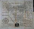
English: A natural-color image of the black and white reprint (15×12.5 inches) of Charles Bertram's map from his forged account The Description of Britain (Latin: De Situ Britanniae).

→→→A historical forgery and not to be used as an accurate map.←←←

Text:
Mappa Britanniae Facie i Romanae Secundum Fidem Monumentorum Pervertum Depicta

Tabulam hanc Geographicam Antiquitatis Patriae Cimelium celeberrimo viro Gulielmo Stukeley M.D., C.L.M., F.R.S.eet observantiae testandae ergo D. D. Carolus Bertramus 1755.
C. Bertramus ipse delin: ab orig. & sculpsit.

[motto:] Si Sit Rudent


Printed for White & Co. Horace's Head Fleet Street June 1.1809.

日付
原典 Charles Bertram's "mappa britanniæ facie i romanæ secvndvm fidem monvmentorvm pervertervm depicta" (Copenhagen: 1755), published in color in Britannicarum Gentium Historiæ Antiquæ Scriptores Tres: Richardus Corinensis, Gildas Badonicus, Nennius Banchorensis [Three Authors of the Ancient History of the Britannic People: Richard the Corinese, Gildas the Badonic, Nennius the Bangorian] (Copenhagen: 1757), reprinted in black and white in The Description of Britain, Translated from Richard of Cirencester: with the Original Treatise De Situ Britanniæ; and a Commentary on the Itinerary; Illustrated with Maps (London: 1809), p. xxv.
作者 Charles Bertram
その他のバージョン

ライセンス

Public domain

この著作物は、著作権の保護期間が著作者の死後100年以下である国・地域においてパブリックドメインの状態にあります。


この著作物は1929年1月1日以前に公表され、又はアメリカ合衆国著作権局に登録されたため、アメリカ合衆国においてパブリックドメインの状態にあります。

[[Category:Maps of the history of Ireland]

キャプション

このファイルの内容を1行で記述してください

このファイルに描写されている項目

題材

ファイルの履歴

過去の版のファイルを表示するには、その版の日時をクリックしてください。

日付と時刻サムネイル寸法利用者コメント
現在の版2015年3月5日 (木) 20:252015年3月5日 (木) 20:25時点における版のサムネイル1,500 × 1,312 (4.43メガバイト)LlywelynIIUser created page with UploadWizard

以下のページがこのファイルを使用しています: