ファイル:Memorial to the Aer Lingus crash of January 1952 - 1784244.jpg
このプレビューのサイズ: 800 × 558 ピクセル。 その他の解像度: 320 × 223 ピクセル | 640 × 446 ピクセル | 1,024 × 714 ピクセル。
元のファイル (1,024 × 714 ピクセル、ファイルサイズ: 224キロバイト、MIME タイプ: image/jpeg)
ウィキメディア・コモンズのファイルページにある説明を、以下に表示します。
|
概要
| 解説 |
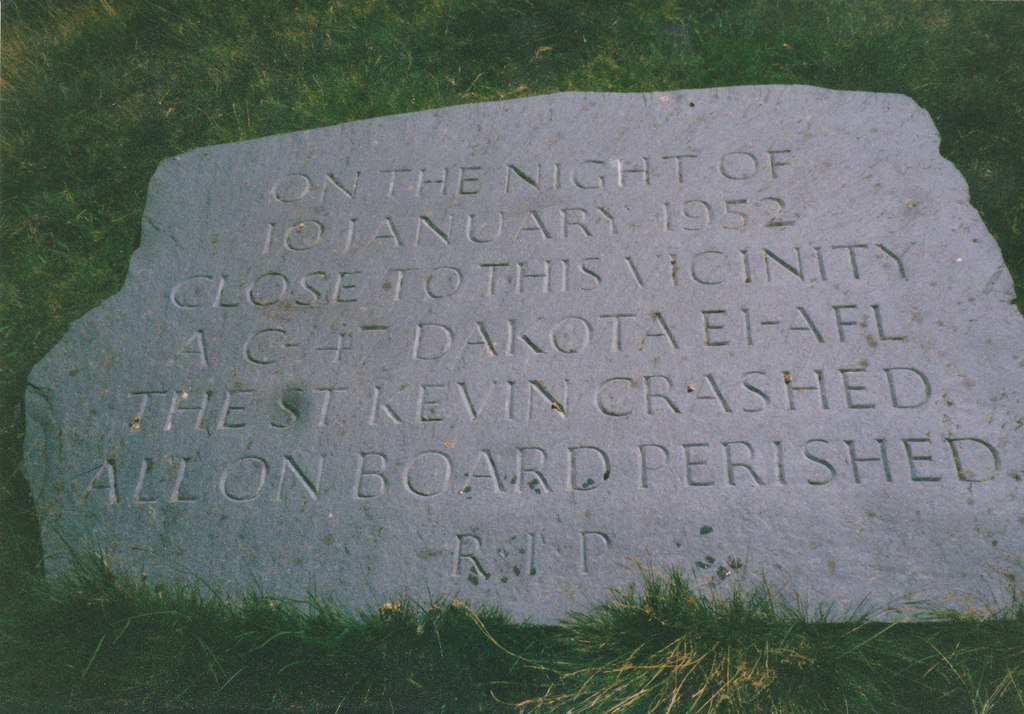
English: Memorial to the passengers and crew of Aer Lingus crash of 10 January 1952, 4 km from Plas Gwynant, Gwynedd, Great Britain.
The Douglas DC-3 (named 'Saint Kevin') owned by Aer Lingus left RAF Northolt, London at 17:25 on 10th January, 1952 on a flight to Dublin. Radio contact with the plane was lost shortly after the pilot requested permission from Dublin control at around 19:15 to descend from 6500 ft to 4500 ft. A board of inquiry came to the conclusion that the descending plane encountered a "powerful down-current of air on the lee side of Snowdon which forced the aircraft down into an area of very great turbulence .." which led the pilot, Capt Keohane, to "lose control.." Even in mid summer, the Cwm Edno bog at 1.500ft, is an inhospitable place. The conditions on that night in January, 1952 were absolutely atrocious. I remember at the time Police Constable Jones, stationed at Deiniolen, describing the scene of utter devastation which met officers who had had to climb for almost an hour to the site from the Llyn Gwynant road, how sections of the wreckage and many bodies had been sucked into the muddy bog and how a little child's doll had on impact been thrown clear of the burning wreckage, something which upset the men greatly. |
| 日付 | |
| 原典 | From this image at geograph.org.uk; transferred by User:RHaworth using geograph_org2commons. |
| 作者 | Eric Jones |
| その他のバージョン |
|
| 帰属 (ライセンスによる要求事項) | Eric Jones / Memorial to the passengers and crew of Aer Lingus crash of 10th January 1952 / |


| カメラの位置 | | 以下のサービスでこの位置を確認する: オープンストリートマップ |
|---|
| 被写体の位置 | | 以下のサービスでこの位置を確認する: オープンストリートマップ |
|---|
_region:GB-GBN_heading:157.00&language=ja)
ライセンス

|
この写真はGeograph projectコレクションから提供されています。撮影者の連絡先の詳細はGeographの公式サイトにある写真ページをご覧ください。この画像の著作権はEric Jonesに帰属しており、クリエイティブ・コモンズ 表示 - 継承 2.0 ライセンスの下に利用を許諾されています。
|
このファイルはクリエイティブ・コモンズ 表示-継承 2.0 一般ライセンスのもとに利用を許諾されています。
帰属: Eric Jones
- あなたは以下の条件に従う場合に限り、自由に
- 共有 – 本作品を複製、頒布、展示、実演できます。
- 再構成 – 二次的著作物を作成できます。
- あなたの従うべき条件は以下の通りです。
- 表示 – あなたは適切なクレジットを表示し、ライセンスへのリンクを提供し、変更があったらその旨を示さなければなりません。これらは合理的であればどのような方法で行っても構いませんが、許諾者があなたやあなたの利用行為を支持していると示唆するような方法は除きます。
- 継承 – もしあなたがこの作品をリミックスしたり、改変したり、加工した場合には、あなたはあなたの貢献部分を元の作品とこれと同一または互換性があるライセンスの下に頒布しなければなりません。
ファイルの履歴
過去の版のファイルを表示するには、その版の日時をクリックしてください。
| 日付と時刻 | サムネイル | 寸法 | 利用者 | コメント | |
|---|---|---|---|---|---|
| 現在の版 | 2010年9月27日 (月) 22:49 | | 1,024 × 714 (224キロバイト) | File Upload Bot (Magnus Manske) | == {{int:filedesc}} == {{Information |Description={{en|1=Memorial to the passengers and crew of Aer Lingus crash of 10th January 1952, 4 km from Plas Gwynant, Gwynedd, Great Britain. The Douglas DC-3 (named 'Saint Kevin') owned by Aer Lingus lef |
ファイルの使用状況
以下のページがこのファイルを使用しています:
グローバルなファイル使用状況
以下に挙げる他のウィキがこの画像を使っています:
- en.wikipedia.org での使用状況
- hu.wikipedia.org での使用状況
- tr.wikipedia.org での使用状況