ファイル:Miners Needle from Bluff Spring Trail, Superstition Wilderness.jpg

このプレビューのサイズ: 800 × 600 ピクセル。 その他の解像度: 320 × 240 ピクセル | 640 × 480 ピクセル | 1,024 × 768 ピクセル | 1,280 × 960 ピクセル | 2,560 × 1,920 ピクセル | 3,648 × 2,736 ピクセル。
元のファイル (3,648 × 2,736 ピクセル、ファイルサイズ: 2.3メガバイト、MIME タイプ: image/jpeg)
ウィキメディア・コモンズのファイルページにある説明を、以下に表示します。
|
概要
| 解説 |
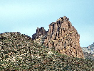
English: This is the view looking northeast at Miner's Needle from the Bluff Spring Trail. This area figures prominently in the legends of gold in the Supes. The Lost Dutchman's Mine is thought to be near here.
I hiked the Charleyboy Duece Loop - the hike shown as Charlebois Loop II in "Hiker's Guide to the Superstition Wilderness" by Jack Stewart and Liz Carlson. From Wikipedia: "The Superstition Mountains, popularly referred to as "The Superstitions" or "The Supes", are a range of mountains in Arizona located to the east of the Phoenix metropolitan area. They are anchored by Superstition Mountain, a large mountain that is a popular recreation destination for residents of the Phoenix, Arizona area. The mountain range is in the federally-designated Superstition Wilderness Area, and includes a variety of natural features in addition to the mountain that is its namesake. Weaver's Needle, a prominent landmark and rock climbing destination set behind and to the east of Superstition Mountain, is a tall erosional remnant [1] that plays a significant role in the legend of the Lost Dutchman's Gold Mine. Peralta Canyon, on the northeast side of Superstition Mountain, contains a popular trail that leads up to Freemont Saddle, which provides a very picturesque view of Weaver's Needle. Miner's Needle is another prominent formation in the wilderness and a popular hiking destination." |
| 日付 | |
| 原典 |
Miner's Needle from Bluff Spring Trail - Superstition Wilderness
|
| 作者 | Alan English CPA from Scottsdale, Arizona 85254, USA |
| カメラの位置 | | 以下のサービスでこの位置を確認する: オープンストリートマップ |
|---|
ライセンス
このファイルはクリエイティブ・コモンズ 表示-継承 2.0 一般ライセンスのもとに利用を許諾されています。
- あなたは以下の条件に従う場合に限り、自由に
- 共有 – 本作品を複製、頒布、展示、実演できます。
- 再構成 – 二次的著作物を作成できます。
- あなたの従うべき条件は以下の通りです。
- 表示 – あなたは適切なクレジットを表示し、ライセンスへのリンクを提供し、変更があったらその旨を示さなければなりません。これらは合理的であればどのような方法で行っても構いませんが、許諾者があなたやあなたの利用行為を支持していると示唆するような方法は除きます。
- 継承 – もしあなたがこの作品をリミックスしたり、改変したり、加工した場合には、あなたはあなたの貢献部分を元の作品とこれと同一または互換性があるライセンスの下に頒布しなければなりません。
| 当初、Flickrに投稿されたこの画像は、February 19, 2011に管理者又は画像査読者のFile Upload Bot (Magnus Manske)によって査読され、その時点で、Flickr上で記載されたライセンスの下で利用可能であることが確認されました。 |
ファイルの履歴
過去の版のファイルを表示するには、その版の日時をクリックしてください。
| 日付と時刻 | サムネイル | 寸法 | 利用者 | コメント | |
|---|---|---|---|---|---|
| 現在の版 | 2011年2月19日 (土) 23:06 | | 3,648 × 2,736 (2.3メガバイト) | File Upload Bot (Magnus Manske) | {{Information |Description=This is the view looking northeast at Miner's Needle from the Bluff Spring Trail. This area figures prominently in the legends of gold in the Supes. The Lost Dutchman's Mine is thought to be near here. I hiked the Charleyboy |
ファイルの使用状況
以下のページがこのファイルを使用しています:
グローバルなファイル使用状況
以下に挙げる他のウィキがこの画像を使っています:
- de.wikipedia.org での使用状況
- en.wikipedia.org での使用状況
- nl.wikipedia.org での使用状況
- pl.wikipedia.org での使用状況
- www.wikidata.org での使用状況