ファイル:NE 600ad.jpg
元のファイル (1,439 × 1,086 ピクセル、ファイルサイズ: 1.14メガバイト、MIME タイプ: image/jpeg)
ウィキメディア・コモンズのファイルページにある説明を、以下に表示します。
|
概要
| 解説 |
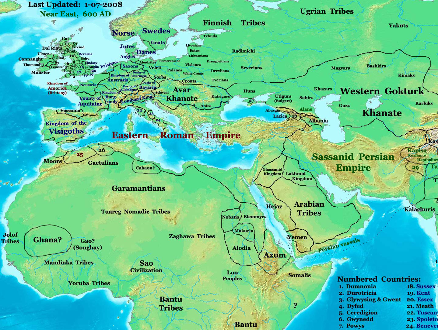
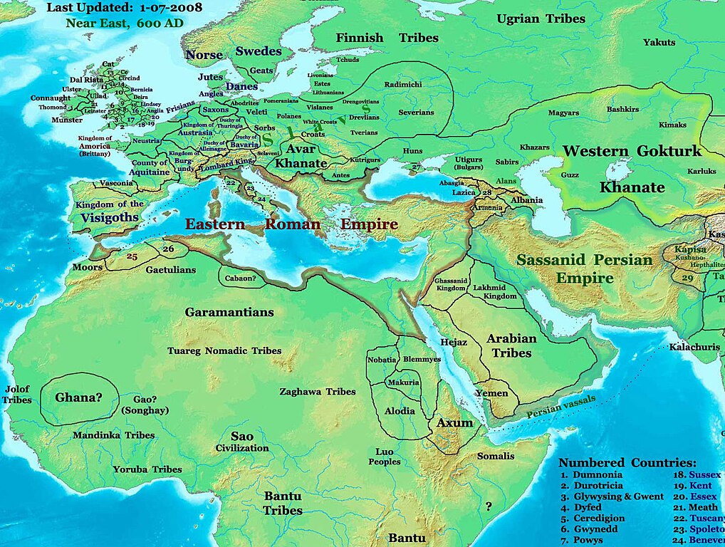
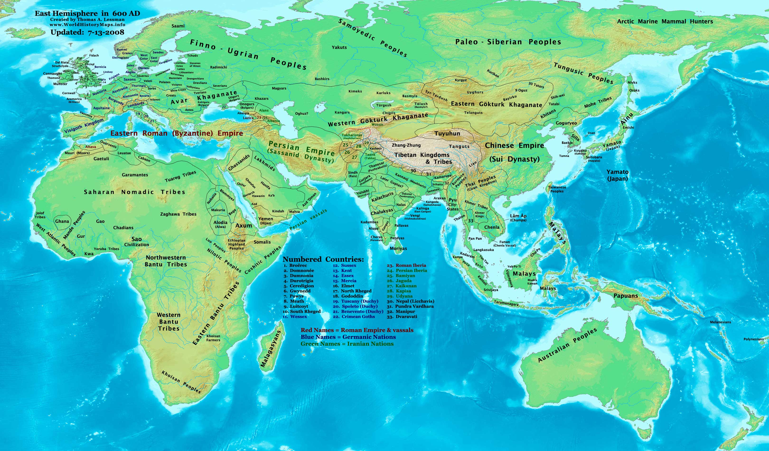
English: part of: Eastern Hemisphere in 600 AD.
Description: This image is a zoomed-in version of the Eastern Hemisphere in 600 AD. Author: Thomas A. Lessman (talessman@yis.us), later modified by others. Source URL: http://www.worldhistorymaps.info/images/East-Hem_600ad.jpg. Image Summary:Created by Thomas Lessman, based on this map of Eastern Hemisphere in 600 AD. Free for educational use. If you use this image, please credit the author (Thomas Lessman) and include (Source URL: http://www.worldhistorymaps.info/images/East-Hem_600ad.jpg). If you can help improve this map, please contact Thomas Lessman at talessman@yis.us. Other Historical Maps by Thomas Lessman
|
|||||||||||||||||||||||||
| 日付 | 2008年1月17日 (当初のアップロード日) | |||||||||||||||||||||||||
| 原典 | en.wikipedia からコモンズに移動されました。 | |||||||||||||||||||||||||
| 作者 | 英語版ウィキペディアのTalessmanさん | |||||||||||||||||||||||||
| 許可 (ファイルの再利用) |
|
|||||||||||||||||||||||||
| その他のバージョン | Disputed map because the version with « Romanised Dacians » (= Olahok, Vlachs) and « Slavs » (Totok, Slavons, Slovens...) may be a romanian and slavic POV, but this « Only Avars and no other people north of the Danube, in the future Kingdom of Hungary », according to the Eduard Rössler's « Awarenwüste » theory, shows an Austrian-Hungarian POV: one is not more objective than the other and unfortunately no synthesis is possible. | |||||||||||||||||||||||||
ライセンス

|
この文書は、フリーソフトウェア財団発行のGNUフリー文書利用許諾書 (GNU Free Documentation License) 1.2またはそれ以降のバージョンの規約に基づき、複製や再配布、改変が許可されます。不可変更部分、表紙、背表紙はありません。このライセンスの複製は、GNUフリー文書利用許諾書という章に含まれています。 |
| このファイルはクリエイティブ・コモンズ 表示-継承 3.0 非移植ライセンスのもとに利用を許諾されています。 | ||
| 帰属: Talessman at the English Wikipedia | ||
| ||
| このライセンスのテンプレートは、GFDLのライセンス・アップデートによりこのファイルに追加されたものです。 |
| Maps of the eastern hemisphere showing history
Bold dates are available on Wikimedia or Wikipedia. | ||
| Primeval | ||
| Ancient
|
·| 600 BC | 550 BC | 527 BC | 500 BC |
400 BC | ·| 1 AD | 50 AD | 100 AD | 200 AD | 300 AD | | |
| Medieval |
·| 500 AD | 565 AD | 600 AD | 700 AD | | |
| Modern |
·| 1500 AD | · * For historical maps of the whole world, | |
·
元のアップロードログ
- 2008-01-17 20:07 Talessman 1439×1086× (513542 bytes) Added more info for Africa, corrected some info on Europe.
- 2007-11-02 18:55 Talessman 1450×988× (440135 bytes) Corrected borders in Africa/Sudan and Arabia.
- 2007-10-31 20:30 Talessman 1429×927× (437106 bytes) Corrected borders of Ghana, made other names easier to read, other misc. corrections.
- 2007-10-21 00:19 Talessman 1251×779× (341469 bytes) Author: Thomas A. Lessman. Source URL: http://www.ThomasLessman.com/History/images/East-Hem_600ad.jpg. Image was created by me (Thomas Lessman) based on map of Eastern Hemisphere in 600ad. Image is free for public and/or educational use. I would appreciat
ファイルの履歴
過去の版のファイルを表示するには、その版の日時をクリックしてください。
| 日付と時刻 | サムネイル | 寸法 | 利用者 | コメント | |
|---|---|---|---|---|---|
| 現在の版 | 2024年3月7日 (木) 17:26 | | 1,439 × 1,086 (1.14メガバイト) | Nihil scimus | Restored a more accurate map uploaded march 15, 2023 by Moodylo333: Armenia was not Byzantine (see Claude Murafian's & Eric Van Lauwe's ''Atlas historique de l'Arménie'', Autrement publ., ISBN 2746701006); Highlighted the boundaries of the Eastern Roman Empire, Sassanid Persia and the Göktürk Khanate; Drawn the Slavic perimeter and reduced the Avar perimeter (greatly exaggerated) according to [https://commons.wikimedia.org/wiki/File:Avar_settlement_area.jpg] and to Vladislav Popovic's «La des... |
| 2023年9月26日 (火) 19:28 |  | 1,439 × 1,086 (502キロバイト) | OrionNimrod | Reverted to version as of 09:20, 1 February 2009 (UTC) keep original | |
| 2023年3月15日 (水) 16:28 |  | 1,439 × 1,086 (1.14メガバイト) | Moodylo333 | More accurate map: see explanations. | |
| 2022年10月28日 (金) 13:38 |  | 1,439 × 1,086 (502キロバイト) | OrionNimrod | Reverted to version as of 09:20, 1 February 2009 (UTC) "Romance Dacians in 600" in Transylvania is clearly a Romanian nationalist POV, and there is Avar archeological sites, but the Avar territory was decreased in the updated map. Dacians in 600??? | |
| 2022年10月27日 (木) 15:47 |  | 1,439 × 1,086 (744キロバイト) | Nihil scimus | Modifications from academic historical books do not "invent nations" or falsifie Commons' digital incomplete maps, but enrich them. | |
| 2022年10月6日 (木) 17:29 |  | 1,439 × 1,086 (502キロバイト) | OrionNimrod | Reverted to version as of 09:20, 1 February 2009 (UTC) restored the original one which was extract from the big original map, the map was falsified with did not exist nations at that time 600 AD | |
| 2014年12月11日 (木) 12:55 |  | 1,439 × 1,086 (744キロバイト) | Spiridon Ion Cepleanu | Garamantian & Arabic tribes areas | |
| 2014年11月20日 (木) 17:26 |  | 1,439 × 1,086 (742キロバイト) | Spiridon Ion Cepleanu | Lakes & Caspian shorelines | |
| 2014年11月15日 (土) 13:21 |  | 1,439 × 1,086 (737キロバイト) | Spiridon Ion Cepleanu | Add missing names: Altava, Warsenia, Iberia, Kaikanan | |
| 2014年11月15日 (土) 13:00 |  | 1,439 × 1,086 (736キロバイト) | Spiridon Ion Cepleanu | Little cosmetic adds (seas names in this time, etc) |
ファイルの使用状況
以下のページがこのファイルを使用しています:
グローバルなファイル使用状況
以下に挙げる他のウィキがこの画像を使っています:
- ast.wikipedia.org での使用状況
- az.wikipedia.org での使用状況
- ba.wikipedia.org での使用状況
- bg.wikipedia.org での使用状況
- ca.wikipedia.org での使用状況
- cv.wikipedia.org での使用状況
- el.wikipedia.org での使用状況
- en.wikipedia.org での使用状況
- en.wikiversity.org での使用状況
- es.wikipedia.org での使用状況
- fa.wikipedia.org での使用状況
- fr.wikipedia.org での使用状況
- hu.wikipedia.org での使用状況
- id.wikipedia.org での使用状況
- it.wikipedia.org での使用状況
- ko.wikipedia.org での使用状況
- lt.wikipedia.org での使用状況
このファイルのグローバル使用状況を表示する。