ファイル:NWS 2013 Moore EF5 damage.jpg
このプレビューのサイズ: 800 × 600 ピクセル。 その他の解像度: 320 × 240 ピクセル | 640 × 480 ピクセル | 1,024 × 768 ピクセル | 1,280 × 960 ピクセル。
元のファイル (1,280 × 960 ピクセル、ファイルサイズ: 1.16メガバイト、MIME タイプ: image/jpeg)
ウィキメディア・コモンズのファイルページにある説明を、以下に表示します。
|
概要
| 解説 |
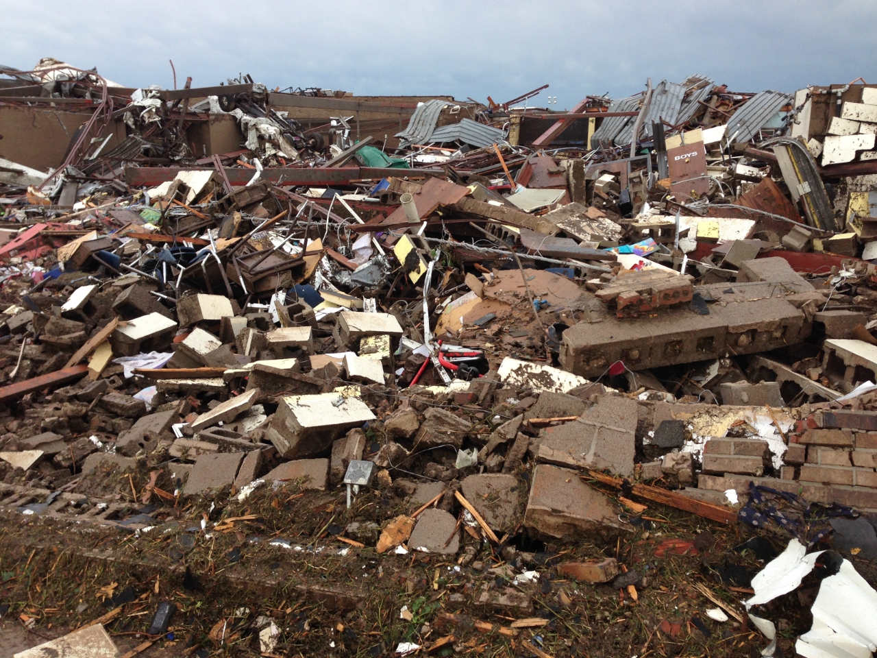
English: 2013 Moore tornado damage at Briarwood Elementary School, EF5 rated by NWS WFO Norman, OK |
| 日付 | |
| 原典 | http://arcgis-nwsdatsecurestd-560264031.us-east-1.elb.amazonaws.com/arcgis/rest/services/DamageAssessmentToolkit/DamageFlexViewer/MapServer/0/141947/attachments/98967 from http://www.srh.noaa.gov/images/oun/wxevents/20130520/20130520-storm_survey_path_points.kmz as linked from http://www.srh.noaa.gov/oun/?n=events-20130520 |
| 作者 | NWS WFO Norman, OK |
| Date of Damage | 05/20/2013 15:48 UTC |
| Date of Survey | 05/21/2013 19:31 UTC |
| EF Rating | EF5 |
| Damage Indicator | Elementary School [Single Story; Interior or Exterior Hallways] (ES) |
| Degree of Damage | Total destruction of a large section of building or entire building |
| Latitude | 35.32133326 |
| Longitude | -97.52087024 |
| カメラの位置 | | 以下のサービスでこの位置を確認する: オープンストリートマップ |
|---|
This File:NWS_2013_Moore_EF5_damage.jpg photo is explicitly identified as an example of EF5 damage in the NWS's kml file http://www.srh.noaa.gov/images/oun/wxevents/20130520/20130520-storm_survey_path_points.kmz as linked from http://www.srh.noaa.gov/oun/?n=events-20130520 as retrieved on 2013-06-17.
ライセンス
|
|
ファイルの履歴
過去の版のファイルを表示するには、その版の日時をクリックしてください。
| 日付と時刻 | サムネイル | 寸法 | 利用者 | コメント | |
|---|---|---|---|---|---|
| 現在の版 | 2013年5月22日 (水) 23:30 | | 1,280 × 960 (1.16メガバイト) | Sitic | {{Information |Description ={{en|1=2013 Moore tornado damage at Briarwood Elementary School, EF5 rated by NWS WFO Norman, OK}} |Source =http://arcgis-nwsdatsecurestd-560264031.us-east-1.elb.amazonaws.com/arcgis/rest/services/DamageAssessment... |
ファイルの使用状況
以下の 2 ページがこのファイルを使用しています:
グローバルなファイル使用状況
以下に挙げる他のウィキがこの画像を使っています:
- am.wikipedia.org での使用状況
- ca.wikipedia.org での使用状況
- cs.wikipedia.org での使用状況
- da.wikipedia.org での使用状況
- de.wikipedia.org での使用状況
- en.wikipedia.org での使用状況
- gl.wikipedia.org での使用状況
- it.wikipedia.org での使用状況
- nl.wikipedia.org での使用状況
- ru.wikipedia.org での使用状況
- ta.wikipedia.org での使用状況
- zh.wikipedia.org での使用状況