ファイル:Noord-Holland position.svg

この SVG ファイルのこの PNG プレビューのサイズ: 200 × 236 ピクセル. その他の解像度: 203 × 240 ピクセル | 407 × 480 ピクセル | 651 × 768 ピクセル | 868 × 1,024 ピクセル | 1,736 × 2,048 ピクセル。
元のファイル (SVG ファイル、200 × 236 ピクセル、ファイルサイズ: 158キロバイト)
ウィキメディア・コモンズのファイルページにある説明を、以下に表示します。
|
概要
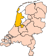
| 解説 | Location of the province of Noord-Holland (North Holland) in the Netherlands. |
| 日付 | |
| 原典 | Own work, based on freely available GIS data |
| 作者 | User:Mtcv |
| 許可 (ファイルの再利用) |
Data: attribution required; my work: PD |
| その他のバージョン | I attempted to make an svg version of Image:Noord Holland-Position.png (with less simplified boundaries) |
Clickable version

ライセンス

|
このファイルの著作権者Centraal Bureau voor de Statistiekは、あらゆる人があらゆる目的でこのファイルを使用することを許可しています。ただし著作権者の名義が適切に表示されることを条件とします。再頒布、二次的著作物の製作、商用利用等のあらゆる使用が許可されています。 |
|
|
| 注釈 | この画像には注釈がついています: コモンズで注釈を見る |


ファイルの履歴
過去の版のファイルを表示するには、その版の日時をクリックしてください。
| 日付と時刻 | サムネイル | 寸法 | 利用者 | コメント | |
|---|---|---|---|---|---|
| 現在の版 | 2019年3月2日 (土) 17:20 | | 200 × 236 (158キロバイト) | Thayts | update |
| 2006年10月2日 (月) 15:13 |  | 200 × 236 (158キロバイト) | Mtcv | {{Information| |Description=Location of the province of Noord-Holland (North Holland) in the Netherlands. |Source=Own work, based on freely available GIS data |Date=2006-10-02 |Author=User:Mtcv |Permission=Data: attribution required; my work: PD |othe |
ファイルの使用状況
このファイルを使用しているページはありません。
グローバルなファイル使用状況
以下に挙げる他のウィキがこの画像を使っています:
- ar.wikipedia.org での使用状況
- أمستردام
- شمال-هولندا
- هلفرسوم
- ألكمار
- هارلم (شمال-هولندا)
- زانستاد
- هارلمرمير
- قالب:بلديات شمال هولندا
- سخاخن
- دن هيلدر
- فيلسن
- زانتفورت
- بلوميندال
- ألسمير
- لاندسمير
- أوستزان
- تيسل
- أمستلفين
- إنكهاوزن
- هورن (هولندا)
- فاترلاند
- بيمستر
- بيفيرفايك
- بيرخن (شمال هولندا)
- بلاريكوم
- هيمستيده
- بوابة:أمستردام/قوالب
- بوابة:أمستردام
- حكومة أمستردام
- هارلمرليده آن سبارنفاودا
- آودر- أمستل
- ديمين
- فيسب (هولندا)
- كاستركوم
- دريخترلاند
- إدام- فولندام
- هيمسكيرك
- هيرهوخوفارد
- هيلو (هولندا)
- هولاندز كرون
- هاوزن
- كوخينلاند
- لانجادايك
- لارين (هولندا)
- ميديمبليك
- أوبمير
- بورميراند
- ستيده بروك
- آوتخيست
- آوتهورن
このファイルのグローバル使用状況を表示する。