ファイル:Obcine Slovenija 2006.svg

この SVG ファイルのこの PNG プレビューのサイズ: 800 × 522 ピクセル. その他の解像度: 320 × 209 ピクセル | 640 × 418 ピクセル | 1,024 × 668 ピクセル | 1,280 × 835 ピクセル | 2,560 × 1,670 ピクセル | 2,613 × 1,705 ピクセル。
元のファイル (SVG ファイル、2,613 × 1,705 ピクセル、ファイルサイズ: 2.31メガバイト)
ウィキメディア・コモンズのファイルページにある説明を、以下に表示します。
|
概要
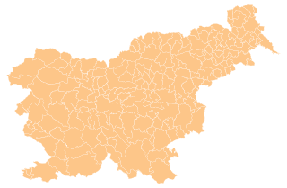
| 解説 | Map of the municipalities (občine) of the Republic of Slovenia, as since May 2006 (210 units). |
| 日付 | |
| 原典 | Source of the public data is GURS (Geodetska uprava Republike Slovenije or Surveying and Mapping Authority of the Republic of Slovenia). Converted from Shapefile to SVG with shp2svg and prepared for Wikipedia by romanm (talk). |
| 作者 | See above. |
| 許可 (ファイルの再利用) |
See Pogoji uporabe (in Slovene) and Terms and conditions (English). According to price list, which states cost 0€ for using free-of-charge published data on municipalities even for commercial purposes(!), I consider the data to be in public domain. I also hereby grant my work on this file to be in public domain. |
| その他のバージョン |
|

ライセンス
| この著作物の著作権者である私は、この著作物における権利を放棄しパブリックドメインとします。これは全世界で適用されます。 一部の国では、これが法的に可能ではない場合があります。その場合は、次のように宣言します。 私は、あらゆる人に対して、法により必要とされている条件を除き、如何なる条件も課すことなく、あらゆる目的のためにこの著作物を使用する権利を与えます。 |
ファイルの履歴
過去の版のファイルを表示するには、その版の日時をクリックしてください。
| 日付と時刻 | サムネイル | 寸法 | 利用者 | コメント | |
|---|---|---|---|---|---|
| 現在の版 | 2012年4月13日 (金) 16:19 | | 2,613 × 1,705 (2.31メガバイト) | Martin Kraft | size and display problem fixed reduced number of points |
| 2008年11月3日 (月) 21:32 |  | 2,613 × 1,705 (2.36メガバイト) | Romanm | fixed aspect ratio Category:Maps of administrative units of Slovenia | |
| 2008年11月3日 (月) 21:21 |  | 512 × 334 (2.36メガバイト) | Romanm | {{Information |Description=Map of the municipalities (''občine'') of the Republic of Slovenia, as since May 2006 (211 units). |Source=Source of [http://www.gu.gov.si/si/delovnapodrocja_gu/podatki_gu/brezplani_podatki/brezplani_podatki_obine/ the public d |
ファイルの使用状況
このファイルを使用しているページはありません。
グローバルなファイル使用状況
以下に挙げる他のウィキがこの画像を使っています:
- ast.wikipedia.org での使用状況
- azb.wikipedia.org での使用状況
- cs.wikipedia.org での使用状況
- de.wikipedia.org での使用状況
- eu.wikipedia.org での使用状況
- kbd.wikipedia.org での使用状況
- la.wikipedia.org での使用状況
- sco.wikipedia.org での使用状況
- sl.wikipedia.org での使用状況
- vi.wikipedia.org での使用状況