ファイル:Ottoman Provinces Of Present day Libya.png
高解像度版はありません。
Ottoman_Provinces_Of_Present_day_Libya.png (282 × 314 ピクセル、ファイルサイズ: 22キロバイト、MIME タイプ: image/png)
ウィキメディア・コモンズのファイルページにある説明を、以下に表示します。
|

|
このlocator map画像は、ベクターイメージである SVG ファイルとして再作成されるべきです。これにはいくつかの利点があります。詳しくはCommons:Media for cleanupを参照してください。この画像の SVG 形式がすでに利用可能である場合は、アップロードしてください。アップロード後、この画像にあるこのテンプレートを{{Vector version available|新しい画像ファイル名.svg}}テンプレートで置き換えてください。
|
概要
| 解説 |
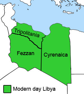
English: The Ottoman Turks conquered the country in the mid-16th century, and the three States or "Wilayat" of Tripolitania, Cyrenaica and Fezzan (which make up Libya) remained part of their empire with the exception of the virtual autonomy of the Karamanlis. The Karamanlis ruled from 1711 until 1835 mainly in Tripolitania, but had influence in Cyrenaica and Fezzan as well by the mid 18th century. |
||
| 日付 | |||
| 原典 | self-made but based on this image on this image and this image | ||
| 作者 | Esemono; improved by Kirk (talk) | ||
| 許可 (ファイルの再利用) |
|
||
| その他のバージョン |
このファイルの派生的著作物:
   |
ファイルの履歴
過去の版のファイルを表示するには、その版の日時をクリックしてください。
| 日付と時刻 | サムネイル | 寸法 | 利用者 | コメント | |
|---|---|---|---|---|---|
| 現在の版 | 2011年8月24日 (水) 12:53 | | 282 × 314 (22キロバイト) | Kirk979 | See discussion |
| 2011年4月11日 (月) 20:46 |  | 300 × 350 (35キロバイト) | ANGELUS | border | |
| 2011年4月11日 (月) 20:35 |  | 300 × 350 (39キロバイト) | ANGELUS | improved | |
| 2009年10月12日 (月) 17:35 |  | 282 × 314 (22キロバイト) | Kirk979 | corrections | |
| 2009年3月1日 (日) 11:00 |  | 282 × 314 (29キロバイト) | Kirk979 | corrections | |
| 2008年4月17日 (木) 13:43 |  | 282 × 314 (25キロバイト) | Esemono | Category:Maps of Libya Category:Map images that should use vector graphics |
ファイルの使用状況
グローバルなファイル使用状況
以下に挙げる他のウィキがこの画像を使っています:
- ar.wikipedia.org での使用状況
- azb.wikipedia.org での使用状況
- az.wikipedia.org での使用状況
- be.wikipedia.org での使用状況
- bg.wikipedia.org での使用状況
- bs.wikipedia.org での使用状況
- ca.wikipedia.org での使用状況
- cs.wikipedia.org での使用状況
- da.wikipedia.org での使用状況
- el.wikipedia.org での使用状況
- en.wikipedia.org での使用状況
- Cyrenaica
- Districts of Libya
- Fezzan
- Tripolitania
- Governorates of Libya
- Subdivisions of Libya
- Provinces of Libya
- Postage stamps and postal history of Tripolitania
- Kingdom of Libya
- Postage stamps and postal history of Cyrenaica
- Postage stamps and postal history of Libya
- Postage stamps and postal history of Fezzan and Ghadames
- Template:Regions of Libya
- Category:Regions of Libya
- Revenue stamps of Libya
- Tripolitania (province of Libya)
- Cyrenaica province
- Fezzan province
このファイルのグローバル使用状況を表示する。