ファイル:Overview of the Gale Crater Landing Site.jpg

このプレビューのサイズ: 430 × 600 ピクセル。 その他の解像度: 172 × 240 ピクセル | 344 × 480 ピクセル | 551 × 768 ピクセル | 734 × 1,024 ピクセル | 1,469 × 2,048 ピクセル | 3,856 × 5,376 ピクセル。
元のファイル (3,856 × 5,376 ピクセル、ファイルサイズ: 3.8メガバイト、MIME タイプ: image/jpeg)
ウィキメディア・コモンズのファイルページにある説明を、以下に表示します。
|
概要
| 解説 |
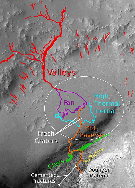
English: This graphic shows key features at the MSL landing site in Gale crater. A possible traverse path is shown in orange. Branching valleys from the crater wall lead to an alluvial fan in the center of the ellipse. At the end of the alluvial fan, the terrain transitions to a fractured, layered unit with a high thermal inertia. Several fresh craters in this unit are accessible. The primary target of the mission is the clay-bearing unit on the lower portion of the layered central mound, and its transition to the overlying sulfate-bearing layers. Cemented fractures in the sulfate-bearing rocks suggest groundwater interactions. A light-toned lens of younger material, heavily eroded by wind, marks the end of the notional traverse. |
| 日付 | |
| 原典 | The basemap for this image is a mosaic of images from the Context Camera (CTX) on the Mars Reconnaissance Orbiter (MRO). Clay and sulfate units are based on mineral parameter maps generated by Milliken et al., 2010 using data from the Compact Reconnaissance Imaging Spectrometer for Mars (CRISM) on MRO. Other units and features are adapted from Anderson and Bell, 2010 |
| 作者 | Ryan Anderson |
ライセンス
この作品の著作権者である私は、この作品を以下のライセンスで提供します。
このファイルはクリエイティブ・コモンズ 表示-継承 3.0 非移植ライセンスのもとに利用を許諾されています。
- あなたは以下の条件に従う場合に限り、自由に
- 共有 – 本作品を複製、頒布、展示、実演できます。
- 再構成 – 二次的著作物を作成できます。
- あなたの従うべき条件は以下の通りです。
- 表示 – あなたは適切なクレジットを表示し、ライセンスへのリンクを提供し、変更があったらその旨を示さなければなりません。これらは合理的であればどのような方法で行っても構いませんが、許諾者があなたやあなたの利用行為を支持していると示唆するような方法は除きます。
- 継承 – もしあなたがこの作品をリミックスしたり、改変したり、加工した場合には、あなたはあなたの貢献部分を元の作品とこれと同一または互換性があるライセンスの下に頒布しなければなりません。
ファイルの履歴
過去の版のファイルを表示するには、その版の日時をクリックしてください。
| 日付と時刻 | サムネイル | 寸法 | 利用者 | コメント | |
|---|---|---|---|---|---|
| 現在の版 | 2011年7月30日 (土) 02:41 | | 3,856 × 5,376 (3.8メガバイト) | RyanA1084 |
ファイルの使用状況
以下のページがこのファイルを使用しています:
グローバルなファイル使用状況
以下に挙げる他のウィキがこの画像を使っています:
- ca.wikipedia.org での使用状況
- hr.wikipedia.org での使用状況
- sr.wikipedia.org での使用状況
- zh.wikipedia.org での使用状況