ファイル:PIA16068 - Mars Curiosity Rover - Aeolis Mons - 20120817.jpg

元のファイル (3,294 × 1,568 ピクセル、ファイルサイズ: 583キロバイト、MIME タイプ: image/jpeg)
ウィキメディア・コモンズのファイルページにある説明を、以下に表示します。
|
概要
| 解説 |
English: 08.17.2012
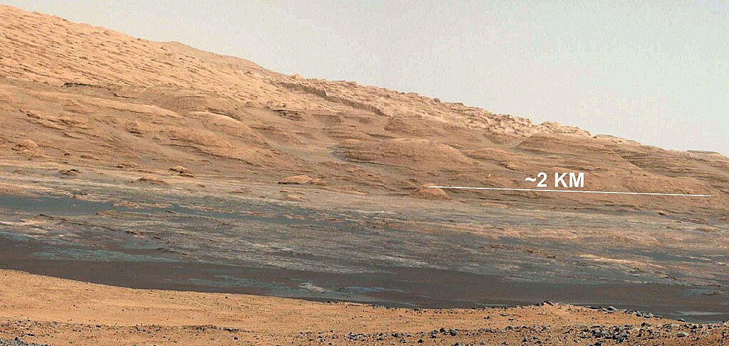
The Promised Land This image (cut out from a mosaic) shows the view from the landing site of NASA's Curiosity rover toward the lower reaches of Mount Sharp, where Curiosity is likely to begin its ascent through hundreds of feet (meters) of layered deposits. The lower several hundred feet (meters) show evidence of bearing hydrated minerals, based on orbiter observations. The terrain Curiosity will explore is marked by hills, buttes, mesas and canyons on the scale of one-to-three story buildings, very much like the Four Corners region of the western United States. A scale bar indicates a distance of 1.2 miles (2 kilometers). Curiosity's 34-millimeter Mast Camera acquired this high-resolution image on Aug. 8, 2012 PDT (Aug. 9 EDT). This image shows the colors modified as if the scene were transported to Earth and illuminated by terrestrial sunlight. This processing, called "white balancing," is useful to scientists for recognizing and distinguishing rocks by color in more familiar lighting. Image Credit: NASA/JPL-Caltech/MSSS |
| 日付 | |
| 原典 | https://photojournal.jpl.nasa.gov/catalog/PIA16068 |
| 作者 | NASA/JPL-Caltech/MSSS |
ライセンス
| このファイルはアメリカ航空宇宙局(NASA)によって作成されたものです。NASAの著作権の方針では、特記事項が無い場合、NASAの資料はパブリックドメインとなります。 (詳しくはTemplate:PD-USGov、NASAの著作権の方針について(英語)又はジェット推進研究所(JPL)の画像使用に関するガイドライン(英語)をご覧ください。) |
||
 |
注意事項:
|
ファイルの履歴
過去の版のファイルを表示するには、その版の日時をクリックしてください。
| 日付と時刻 | サムネイル | 寸法 | 利用者 | コメント | |
|---|---|---|---|---|---|
| 現在の版 | 2012年8月17日 (金) 18:24 | | 3,294 × 1,568 (583キロバイト) | Drbogdan |
ファイルの使用状況
以下のページがこのファイルを使用しています:
グローバルなファイル使用状況
以下に挙げる他のウィキがこの画像を使っています:
- azb.wikipedia.org での使用状況
- az.wikipedia.org での使用状況
- bn.wikipedia.org での使用状況
- ca.wikipedia.org での使用状況
- en.wikipedia.org での使用状況
- fa.wikipedia.org での使用状況
- kk.wikipedia.org での使用状況
- ko.wikipedia.org での使用状況
- mk.wikipedia.org での使用状況
- ro.wikipedia.org での使用状況
- ru.wikipedia.org での使用状況
- test.wikipedia.org での使用状況
- th.wikipedia.org での使用状況
- tr.wikipedia.org での使用状況
- uk.wikipedia.org での使用状況
- zh.wikipedia.org での使用状況