ファイル:Panama canal panoramic view from the top of Ancon hill.jpg

元のファイル (10,557 × 1,248 ピクセル、ファイルサイズ: 5.15メガバイト、MIME タイプ: image/jpeg)
ウィキメディア・コモンズのファイルページにある説明を、以下に表示します。
|
| 解説 |
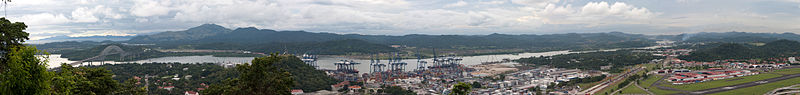
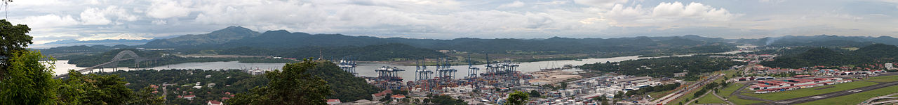
The other side of the hill - view of the canal and Bridge of the Americas connecting east to west and north to south! The Panama Canal is a ship canal which joins the Caribbean Sea to the Pacific ocean. One of the largest and most difficult engineering projects ever undertaken, it had an enormous impact on shipping between the two oceans, replacing the long and treacherous route via the Drake Passage and Cape Horn at the southernmost tip of South America. A ship sailing from New York to San Francisco via the canal travels 9,500 km (6,000 miles), well under half the 22,500 km (14,000 miles) route around Cape Horn.[1] Although the concept of a canal near Panama dates back to the early 16th century, the first attempt to construct a canal began in 1880 under French leadership. After this attempt failed and 21,900 workers died, the project of building a canal was attempted and completed by the United States in the early 1900s, with the canal opening in 1914. The building of the 77 km (48 mi) canal was plagued by problems, including disease (particularly malaria and yellow fever) and landslides. By the time the canal was completed, a total of 27,500 workmen are estimated to have died in the French and American efforts. Since opening, the canal has been enormously successful, and continues to be a key conduit for international maritime trade. The canal can accommodate vessels from small private yachts up to large commercial vessels. The maximum size of vessel that can use the canal is known as Panamax; an increasing number of modern ships exceed this limit, and are known as post-Panamax or super-Panamax vessels. A typical passage through the canal by a cargo ship takes approximately 8–10 hours. In fiscal year 2008, 14,702 vessels passed through the waterway with a total 309.6 million Panama Canal/Universal Measurement System (PC/UMS) tons. While the Pacific Ocean is west of the isthmus and the Atlantic to the east, the journey through the canal from the Pacific to the Atlantic is one from southeast to northwest. This is a result of the isthmus's "curving back on itself" in the region of the canal. The Bridge of the Americas at the Pacific end is about a third of a degree of longitude east of the end near Colon on the Atlantic.[2] An estimated 14,000 ships pass through the canal each year. Only 1,000 ships per year passed through the canal at its beginnings. |
| 日付 | 撮影日:2009年11月7日, 19:05 |
| 原典 | Panama canal panoramic view from the top of Ancon hill |
| 作者 | Brian Gratwicke |
| その他のバージョン | このファイルの派生的著作物: Panama canal banner.jpg |
| カメラの位置 | | 以下のサービスでこの位置を確認する: オープンストリートマップ |
|---|
ライセンス
- あなたは以下の条件に従う場合に限り、自由に
- 共有 – 本作品を複製、頒布、展示、実演できます。
- 再構成 – 二次的著作物を作成できます。
- あなたの従うべき条件は以下の通りです。
- 表示 – あなたは適切なクレジットを表示し、ライセンスへのリンクを提供し、変更があったらその旨を示さなければなりません。これらは合理的であればどのような方法で行っても構いませんが、許諾者があなたやあなたの利用行為を支持していると示唆するような方法は除きます。
| この画像は当初、brian.gratwicke によって Flickr の https://flickr.com/photos/19731486@N07/4084739236 に投稿されたものです。2017-10-04、FlickreviewR ボットによってレビューされ、cc-by-2.0 のライセンスで提供されていることが確認されました。 |
ファイルの履歴
過去の版のファイルを表示するには、その版の日時をクリックしてください。
| 日付と時刻 | サムネイル | 寸法 | 利用者 | コメント | |
|---|---|---|---|---|---|
| 現在の版 | 2009年11月12日 (木) 00:21 | 10,557 × 1,248 (5.15メガバイト) | Raeky | {{Information |Description=The other side of the hill - view of the canal and Bridge of the Americas connecting east to west and north to south! The Panama Canal is a ship canal which joins the Caribbean Sea to the Pacific ocean. One of the largest and mo |
ファイルの使用状況
以下のページがこのファイルを使用しています:
グローバルなファイル使用状況
以下に挙げる他のウィキがこの画像を使っています:
- as.wikipedia.org での使用状況
- bn.wikipedia.org での使用状況
- ca.wikipedia.org での使用状況
- ckb.wikipedia.org での使用状況
- en.wikipedia.org での使用状況
- es.wikipedia.org での使用状況
- eu.wikipedia.org での使用状況
- fa.wikipedia.org での使用状況
- fr.wikipedia.org での使用状況
- gl.wikipedia.org での使用状況
- hak.wikipedia.org での使用状況
- hy.wikipedia.org での使用状況
- ka.wikipedia.org での使用状況
- kk.wikipedia.org での使用状況
- kn.wikipedia.org での使用状況
- mr.wikipedia.org での使用状況
- pt.wikipedia.org での使用状況
- ta.wikipedia.org での使用状況
- th.wikipedia.org での使用状況
- uk.wikipedia.org での使用状況
- zh.wikipedia.org での使用状況