ファイル:Raleigh-Durham-Cary CSA.png
高解像度版はありません。
Raleigh-Durham-Cary_CSA.png (654 × 266 ピクセル、ファイルサイズ: 40キロバイト、MIME タイプ: image/png)
ウィキメディア・コモンズのファイルページにある説明を、以下に表示します。
|
| 解説 |
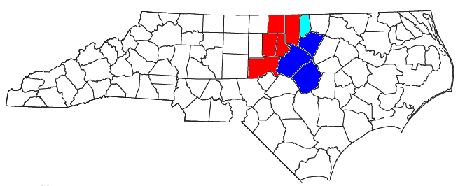
Locator map of the Raleigh-Durham-Chapel Hill Combined Statistical Area in the north central part of the U.S. state of North Carolina. The three components of the CSA are colored separately:
|
||
| 日付 | |||
| 原典 |
Modified from this United States Census Bureau file, based on the following Census definitions list:
|
||
| 作者 | User:Nyttend, Yassie | ||
| 許可 (ファイルの再利用) |
US Government work is public domain, and our work is
|
||
| その他のバージョン | このファイルの派生的著作物: Research triangle.PNG |
ファイルの履歴
過去の版のファイルを表示するには、その版の日時をクリックしてください。
| 日付と時刻 | サムネイル | 寸法 | 利用者 | コメント | |
|---|---|---|---|---|---|
| 現在の版 | 2019年9月11日 (水) 15:35 | 654 × 266 (40キロバイト) | Yassie | New CSA defenition by OMB, 14/Sep/2018 | |
| 2013年4月22日 (月) 15:39 | 654 × 266 (40キロバイト) | Yassie | New CSA defenition by OMB, 28/Feb/2013 | ||
| 2008年7月28日 (月) 15:37 | 654 × 266 (29キロバイト) | Nyttend | {{Information |Description=Locator map of the {{w|The Triangle (North Carolina)|Raleigh-Durham-Cary}} {{w|Combined Statistical Area}} in the north central part of the {{w|U.S. state}} of {{w|North Carolina}}. The three components of the CSA are colored s |
ファイルの使用状況
以下のページがこのファイルを使用しています:
グローバルなファイル使用状況
以下に挙げる他のウィキがこの画像を使っています:
- ar.wikipedia.org での使用状況
- en.wikipedia.org での使用状況
- Raleigh, North Carolina
- Chapel Hill, North Carolina
- Wake County, North Carolina
- Person County, North Carolina
- Orange County, North Carolina
- Johnston County, North Carolina
- Harnett County, North Carolina
- Franklin County, North Carolina
- Durham County, North Carolina
- Chatham County, North Carolina
- Pittsboro, North Carolina
- Siler City, North Carolina
- Butner, North Carolina
- Clayton, North Carolina
- Smithfield, North Carolina
- Carrboro, North Carolina
- Hillsborough, North Carolina
- Roxboro, North Carolina
- Apex, North Carolina
- Fuquay-Varina, North Carolina
- Garner, North Carolina
- Holly Springs, North Carolina
- Wake Forest, North Carolina
- Cary, North Carolina
- Durham, North Carolina
- Morrisville, North Carolina
- Research Triangle Park
- Research Triangle
- GoTriangle
- North Carolina Central University
- Meredith College
- Shaw University
- Triangle J Council of Governments
- The News & Observer
- Indy Week
- The Daily Tar Heel
- The Herald-Sun (Durham, North Carolina)
- Norman Adrian Wiggins School of Law
- Template:Greater Raleigh, NC
- Carrboro Citizen
- Courier Times
- Template:Durham-Chapel Hill Metropolitan Area
このファイルのグローバル使用状況を表示する。