ファイル:Saint Vincent OnEarth WMS.png

このプレビューのサイズ: 600 × 600 ピクセル。 その他の解像度: 240 × 240 ピクセル | 480 × 480 ピクセル | 768 × 768 ピクセル | 1,215 × 1,215 ピクセル。
元のファイル (1,215 × 1,215 ピクセル、ファイルサイズ: 2.22メガバイト、MIME タイプ: image/png)
ウィキメディア・コモンズのファイルページにある説明を、以下に表示します。
|
| 解説 |
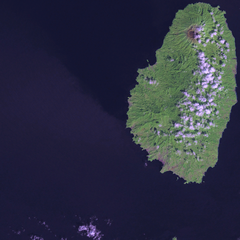
Satellite image of Saint Vincent Screenshot from NASA World Wind, OnEarth WMS global mosaic pseudocolor layer. |
| 日付 | (UTC) |
| 原典 | |
| 作者 |
|
この画像には画像編集が施されています。原本に対して次のデジタル的な変更が行われました。
|
| この画像は、Blue Marble、MODIS、Landsat、SRTM、USGS、GLOBEなどのパブリックドメイン・レイヤーを使用したNASAの地球儀ソフトウェア「World Wind」のスクリーンショットであるため、パブリックドメインの状態にあります。
|
 |
元のアップロードログ
This image is a derivative work of the following images:
- File:Saint_Vincent_and_the_Grenadines_OnEarth_WMS.png licensed with PD-WorldWind
- 2006-04-29T20:36:20Z Hautala 1215x2869 (4062405 Bytes) {{PD-WorldWind}} Satellite image of Saint Vincent and the Grenadines. Screenshot from NASA World Wind, OnEarth WMS layer. [[Category:Satellite images of countries]]
Uploaded with derivativeFX
ファイルの履歴
過去の版のファイルを表示するには、その版の日時をクリックしてください。
| 日付と時刻 | サムネイル | 寸法 | 利用者 | コメント | |
|---|---|---|---|---|---|
| 現在の版 | 2009年1月19日 (月) 16:47 | | 1,215 × 1,215 (2.22メガバイト) | Xfigpower | {{Information |Description=Satellite image of Saint Vincent Screenshot from NASA World Wind, OnEarth WMS global mosaic pseudocolor layer. |Source=*File:Saint_Vincent_and_the_Grenadines_OnEarth_WMS.png |Date=2009-01-19 16:46 (UTC) |Author=*derivative |
ファイルの使用状況
以下のページがこのファイルを使用しています:
グローバルなファイル使用状況
以下に挙げる他のウィキがこの画像を使っています:
- ar.wikipedia.org での使用状況
- az.wikipedia.org での使用状況
- be.wikipedia.org での使用状況
- br.wikipedia.org での使用状況
- ca.wikipedia.org での使用状況
- da.wikipedia.org での使用状況
- de.wikivoyage.org での使用状況
- es.wikipedia.org での使用状況
- fi.wikipedia.org での使用状況
- fi.wiktionary.org での使用状況
- frr.wikipedia.org での使用状況
- fr.wikipedia.org での使用状況
- gl.wikipedia.org での使用状況
- he.wikipedia.org での使用状況
- lb.wikipedia.org での使用状況
- lt.wikipedia.org での使用状況
- pap.wikipedia.org での使用状況
- tr.wikipedia.org での使用状況
- ur.wikipedia.org での使用状況
- www.wikidata.org での使用状況