ファイル:Siege of Homs Map.svg

この SVG ファイルのこの PNG プレビューのサイズ: 588 × 599 ピクセル. その他の解像度: 235 × 240 ピクセル | 471 × 480 ピクセル | 753 × 768 ピクセル | 1,005 × 1,024 ピクセル | 2,009 × 2,048 ピクセル | 883 × 900 ピクセル。
元のファイル (SVG ファイル、883 × 900 ピクセル、ファイルサイズ: 4.91メガバイト)
ウィキメディア・コモンズのファイルページにある説明を、以下に表示します。
|
概要
| 解説 |
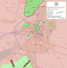
English: Map showing the current strategic situation in Homs as of January 2014.
Red represents area under Government control. Green represents Opposition control. |
||||
| 日付 | |||||
| 原典 | 投稿者自身による著作物 | ||||
| 作者 | MrPenguin20 | ||||
| その他のバージョン |
|


.svg)

.png)


.svg)


.svg)


_Territory_Change_2014-2016.gif)

_(within_Northern_Syria).svg)


.png)
.svg)


_map.png)
.svg)


.svg)


ライセンス
| この著作物には OpenStreetMap の情報が含まれており、オープンデータベースライセンス(ODbL)の下で利用可能です。
当該ライセンスのデータから作成された地図については、何らかの特定のライセンスを付与する必要はありません。2020年8月1日以前は、オープンストリートマップ財団によって作成されたマップタイルはクリエイティブ・コモンズ 表示-継承 2.0(CC-BY-SA-2.0)ライセンスの下に利用が許諾されていました。他の人が作成した地図は、別のライセンスの対象となる場合があります。 |
この作品の著作権者である私は、この作品を以下のライセンスで提供します。
このファイルはクリエイティブ・コモンズ 表示-継承 3.0 非移植ライセンスのもとに利用を許諾されています。
- あなたは以下の条件に従う場合に限り、自由に
- 共有 – 本作品を複製、頒布、展示、実演できます。
- 再構成 – 二次的著作物を作成できます。
- あなたの従うべき条件は以下の通りです。
- 表示 – あなたは適切なクレジットを表示し、ライセンスへのリンクを提供し、変更があったらその旨を示さなければなりません。これらは合理的であればどのような方法で行っても構いませんが、許諾者があなたやあなたの利用行為を支持していると示唆するような方法は除きます。
- 継承 – もしあなたがこの作品をリミックスしたり、改変したり、加工した場合には、あなたはあなたの貢献部分を元の作品とこれと同一または互換性があるライセンスの下に頒布しなければなりません。
ファイルの履歴
過去の版のファイルを表示するには、その版の日時をクリックしてください。
| 日付と時刻 | サムネイル | 寸法 | 利用者 | コメント | |
|---|---|---|---|---|---|
| 現在の版 | 2018年8月3日 (金) 19:35 | | 883 × 900 (4.91メガバイト) | Rr016 | Correction: rebels did not control that much north of Homs |
| 2017年12月10日 (日) 20:36 |  | 883 × 900 (4.92メガバイト) | Kami888 | Made several changes to improve presentation, ask on talk page if any questions. | |
| 2017年10月9日 (月) 17:28 |  | 883 × 900 (4.82メガバイト) | Rr016 | Fixes: added Shamas district, labeled more districts, fixed date of SAA offensive south of Homs, adjusted Bayada frontlines. | |
| 2017年10月8日 (日) 18:07 |  | 883 × 900 (4.82メガバイト) | Rr016 | Major overhaul, inspired by Kami88's Battle of Qalamoun.svg layout. Map now shows all territory lost by opposition from 2012 - 2017. Used https://www.facebook.com/the.arab.chronicle/photos/a.454685571308535.1073741828.453010751476017/524550737655351/?t... | |
| 2014年5月11日 (日) 01:14 |  | 883 × 900 (4.77メガバイト) | MrPenguin20 | Updated map to show current areas of control (will update further to show progression of siege). | |
| 2014年4月20日 (日) 23:02 |  | 883 × 900 (4.77メガバイト) | MrPenguin20 | Update following recent offensives. | |
| 2014年4月8日 (火) 21:14 |  | 883 × 900 (4.77メガバイト) | MrPenguin20 | Changed Dar al-Kabirah to contested. | |
| 2014年2月13日 (木) 22:53 |  | 883 × 900 (4.77メガバイト) | MrPenguin20 | Updated map in line with https://pbs.twimg.com/media/BgWebW3CcAAJLbS.jpg:large | |
| 2014年2月4日 (火) 15:35 |  | 883 × 900 (4.77メガバイト) | MrPenguin20 | Removed "Homs" from center of map. Reworked frontlines in line with map visible at http://online.wsj.com/news/articles/SB10001424052702303277704579346833918268994?mg=reno64-wsj&url=http%3A%2F%2Fonline.wsj.com%2Farticle%2FSB10001424052702303277704579346... | |
| 2014年1月30日 (木) 19:09 |  | 883 × 900 (4.77メガバイト) | MrPenguin20 | Expanded area of opposition control north of Homs. |
ファイルの使用状況
以下のページがこのファイルを使用しています:
グローバルなファイル使用状況
以下に挙げる他のウィキがこの画像を使っています:
- ar.wikipedia.org での使用状況
- azb.wikipedia.org での使用状況
- be.wikipedia.org での使用状況
- cs.wikipedia.org での使用状況
- en.wikipedia.org での使用状況
- es.wikipedia.org での使用状況
- fa.wikipedia.org での使用状況
- fr.wikipedia.org での使用状況
- hu.wikipedia.org での使用状況
- it.wikipedia.org での使用状況
- nl.wikipedia.org での使用状況
- pl.wikipedia.org での使用状況
- ru.wikipedia.org での使用状況
- tr.wikipedia.org での使用状況
- www.wikidata.org での使用状況
- zh.wikipedia.org での使用状況