ファイル:Sri Lanka geopolitics - after "Spoiling of Vijayabahu".png

元のファイル (2,441 × 3,257 ピクセル、ファイルサイズ: 575キロバイト、MIME タイプ: image/png)
ウィキメディア・コモンズのファイルページにある説明を、以下に表示します。
|
概要
| 解説 |
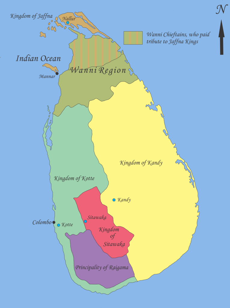
English: Map showing geopolitical situation in Sri Lanka in the early part of 16th century after the “Spoiling of Vijayabahu” in 1521. Map based on following sources;
- “Year 8 History Text Book – Government Publication”, THE ARRIVAL OF THE PORTUGUESE IN SRI LANKA: p14, 06th September 2012. -Fernao de Queyroz. The temporal and spiritual conquest of Ceylon. AES reprint. New Delhi: Asian Educational Services; 1995. p 47-58 ISBN 81-206-0765-1 -Captain Joao Ribeiro. The historic Tragedy of the island of Ceilao. AES Reprint. New Delhi: Asian Educational Services; 1999. p5 ISBN 81-206-1334-1 -Phillipus Baldaeus. A True and Exact Description of the Great Island of Ceylon. English Translation by Pieter Brohier. The Ceylon Historical Journal – Published in Co-operation with the Ceylon Branch of Royal Asiatic Society. Volume III, No 1-4; July 1958 to April 1959. p 300-301 Following maps were used to identify limitations of areas and not for the map itself. -DE L'ISLE:G. - Carte de l'Isle de Ceylan. Published in Paris 1723. http://www.swaen.com/antique-map-of.php?id=1777 , 06 September 2012 - VALENTIJN,F. - Nieuwe Kaart van het Eyland Ceylon opgestelt door. Published in Amsterdam 1724 http://www.swaen.com/antique-map-of.php?id=736 |
| 日付 | |
| 原典 | 投稿者自身による著作物 |
| 作者 | Nishadhi |
ライセンス
- あなたは以下の条件に従う場合に限り、自由に
- 共有 – 本作品を複製、頒布、展示、実演できます。
- 再構成 – 二次的著作物を作成できます。
- あなたの従うべき条件は以下の通りです。
- 表示 – あなたは適切なクレジットを表示し、ライセンスへのリンクを提供し、変更があったらその旨を示さなければなりません。これらは合理的であればどのような方法で行っても構いませんが、許諾者があなたやあなたの利用行為を支持していると示唆するような方法は除きます。
- 継承 – もしあなたがこの作品をリミックスしたり、改変したり、加工した場合には、あなたはあなたの貢献部分を元の作品とこれと同一または互換性があるライセンスの下に頒布しなければなりません。

|
この文書は、フリーソフトウェア財団発行のGNUフリー文書利用許諾書 (GNU Free Documentation License) 1.2またはそれ以降のバージョンの規約に基づき、複製や再配布、改変が許可されます。不可変更部分、表紙、背表紙はありません。このライセンスの複製は、GNUフリー文書利用許諾書という章に含まれています。 |
元のアップロードログ
- 2012-09-21 18:02 Nishadhi 2441×3257× (589067 bytes) Spelling mistake corrected.
- 2012-09-16 15:48 Nishadhi 2441×3257× (589023 bytes) Map showing geopolitical situation in Sri Lanka in the early part of 16th century after the “Spoiling of Vijayabahu” in 1521. Map based on following sources; - “Year 8 History Text Book – Government Publication”, THE ARRIVAL OF THE PORTUGUESE...
ファイルの履歴
過去の版のファイルを表示するには、その版の日時をクリックしてください。
| 日付と時刻 | サムネイル | 寸法 | 利用者 | コメント | |
|---|---|---|---|---|---|
| 現在の版 | 2014年12月25日 (木) 19:04 | | 2,441 × 3,257 (575キロバイト) | OgreBot | (BOT): Reverting to most recent version before archival |
| 2014年12月25日 (木) 19:04 |  | 2,441 × 3,257 (575キロバイト) | OgreBot | (BOT): Uploading old version of file from en.wikipedia; originally uploaded on 2012-09-16 15:48:39 by Nishadhi | |
| 2012年9月21日 (金) 18:25 |  | 2,441 × 3,257 (575キロバイト) | Nishadhi | {{Information |Description ={{en|1=Map showing geopolitical situation in Sri Lanka in the early part of 16th century after the “Spoiling of Vijayabahu” in 1521. Map based on following sources; - “Year 8 History Text Book – Government Public... |
ファイルの使用状況
このファイルを使用しているページはありません。
グローバルなファイル使用状況
以下に挙げる他のウィキがこの画像を使っています:
- ca.wikipedia.org での使用状況
- de.wikipedia.org での使用状況
- en.wikipedia.org での使用状況
- Bayinnaung
- Kingdom of Kandy
- Vanni chieftaincies
- Vijayabā Kollaya
- Kingdom of Kotte
- User:Blackknight12/sandbox
- User:Nishadhi
- Siege of Kotte (1557–1558)
- Campaign of Danture
- Siege of Galle (1640)
- Sinhalese–Portuguese conflicts
- Sinhalese monarchy
- Transitional period of Sri Lanka
- User:Tisquesusa/sandbox9
- User:Blackknight12/sandbox2
- Myanmar–Sri Lanka relations
- fi.wikipedia.org での使用状況
- fr.wikipedia.org での使用状況
- it.wikipedia.org での使用状況
- ka.wikipedia.org での使用状況
- ko.wikipedia.org での使用状況
- my.wikipedia.org での使用状況
- nl.wikipedia.org での使用状況
- pl.wikipedia.org での使用状況
- pt.wikipedia.org での使用状況
- si.wikipedia.org での使用状況
- sl.wikipedia.org での使用状況
- ta.wikipedia.org での使用状況
- ur.wikipedia.org での使用状況
- zh.wikipedia.org での使用状況