ファイル:Texel.jpg
高解像度版はありません。
Texel.jpg (800 × 600 ピクセル、ファイルサイズ: 44キロバイト、MIME タイプ: image/jpeg)
ウィキメディア・コモンズのファイルページにある説明を、以下に表示します。
|
概要
| 解説 |
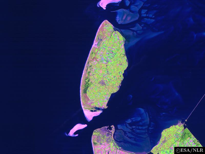
en:False colour en:satellite en:image of the en:island of en:Texel and its surroundings. The image was made by NLR and ESA.NLR and ESA are cited as its source. To the south of the island, part of the en:mainland of the Dutch en:province of en:North Holland can be seen, including the en:city of en:Den Helder (bottom center) and the former island of en:Wieringen (bottom right). Further features include the sand bar of en:Noorderhaaks to the southwest of Texel; the southernmost part of the neighbouring island of en:Vlieland (top center); the en:Afsluitdijk en:dam, which connects North Holland to en:Friesland (center right), the en:Wadden Sea, east of Texel; and the en:North Sea (west of Texel). |
| 日付 | 2004年8月23日 (当初のアップロード日) |
| 原典 | en.wikipedia からコモンズに移動されました。 |
| 作者 | オリジナルのアップロード者は英語版ウィキペディアのCwoyteさん |
ライセンス

|
このファイルの著作者は、著作者の帰属を適切に表示することを条件に、あらゆる目的でこのファイルを使用することを許可しています。再頒布、二次的著作物の制作、商用利用、その他あらゆる利用が許可されています。 |
|
|
元のアップロードログ
元のファイルページはこちら。以下の利用者は全てen.wikipediaに属します。
- 2004-08-23 09:49 Cwoyte 800×600×8 (45082 bytes) Satellite image of the island of Texel and its surroundings.
ファイルの履歴
過去の版のファイルを表示するには、その版の日時をクリックしてください。
| 日付と時刻 | サムネイル | 寸法 | 利用者 | コメント | |
|---|---|---|---|---|---|
| 現在の版 | 2007年5月21日 (月) 17:53 | | 800 × 600 (44キロバイト) | Matanya (usurped) | {{Information |Description=en:False colour en:satellite en:image of the en:island of en:Texel and its surroundings. The image was made by [http://www.npoc.nl NLR] and [http://www.esa.int ESA].NLR and ESA are cited as its source. |
ファイルの使用状況
以下のページがこのファイルを使用しています:
グローバルなファイル使用状況
以下に挙げる他のウィキがこの画像を使っています:
- br.wikipedia.org での使用状況
- de.wiktionary.org での使用状況
- fa.wikipedia.org での使用状況
- fi.wikipedia.org での使用状況
- he.wikipedia.org での使用状況
- is.wikipedia.org での使用状況
- ka.wikipedia.org での使用状況
- ko.wikipedia.org での使用状況
- nl.wikipedia.org での使用状況
- th.wikipedia.org での使用状況
- vi.wikipedia.org での使用状況
- www.wikidata.org での使用状況
- zh.wikipedia.org での使用状況