ファイル:The route of 'The Martian' - from Chryse Planitia over Arabia Terra in the Martian highlands to Ares 4.jpg

このプレビューのサイズ: 749 × 599 ピクセル。 その他の解像度: 300 × 240 ピクセル | 600 × 480 ピクセル | 960 × 768 ピクセル | 1,280 × 1,024 ピクセル | 2,082 × 1,666 ピクセル。
元のファイル (2,082 × 1,666 ピクセル、ファイルサイズ: 2.25メガバイト、MIME タイプ: image/jpeg)
ウィキメディア・コモンズのファイルページにある説明を、以下に表示します。
|


概要
| 解説 |
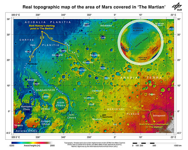
English: As part of the HRSC experiment on board ESA’s Mars Express spacecraft, scientists from the DLR Institute of Planetary Research have mapped the transition zone between the equator and the northern tropic region topographically. On the map, which contains sheet MC11 east, the route that ‘The Martian’, Mark Watney, travelled on Mars has been illustrated. Before he was able to leave his location at Chryse Planitia for the safety of Ares 4 in Schiaparelli Crater, he had to set up a radio transmitter that he obtained at the landing site of the first Mars rover, Soujourner, which arrived on the Red Planet in 1997 as part of the Mars Pathfinder mission. Sojourner was located a few hundred kilometres to the south of Chryse Planitia. His journey continued to the mouth of Mawrth Vallis, which he drove up and gained about 2000 metres in altitude. Following this, Watney drove an additional 2500 metres uphill through the rough Meridiani Planum, which is littered with craters, to the rim of the 450-kilometre diameter Schiaparelli Crater. On the northwestern rim of the crater, a landslide has created a natural ramp that Watney used to access the crater floor, some 700 metres below, where the the Ares-4 rocket was 'parked'. |
||||
| 日付 | |||||
| 原典 | https://www.flickr.com/photos/dlr_de/21344671284/ | ||||
| 作者 | ESA/DLR/FU Berlin – CC BY-SA 3.0 IGO | ||||
| その他のバージョン |
|


ライセンス
This media was created by the European Space Agency (ESA).
Where expressly so stated, images or videos are covered by the Creative Commons Attribution-ShareAlike 3.0 IGO (CC BY-SA 3.0 IGO) licence, ESA being an Intergovernmental Organisation (IGO), as defined by the CC BY-SA 3.0 IGO licence. The user is allowed under the terms and conditions of the CC BY-SA 3.0 IGO license to Reproduce, Distribute and Publicly Perform the ESA images and videos released under CC BY-SA 3.0 IGO licence and the Adaptations thereof, without further explicit permission being necessary, for as long as the user complies with the conditions and restrictions set forth in the CC BY-SA 3.0 IGO licence, these including that:
See the ESA Creative Commons copyright notice for complete information, and this article for additional details.
|
 | |
このファイルはクリエイティブ・コモンズ 表示-継承 3.0 IGO ライセンスのもとに利用を許諾されています。 帰属: ESA/DLR/FU Berlin, CC BY-SA IGO 3.0
| ||
| 当初、Flickr に投稿されたこの画像は、UploadWizard 拡張機能によって査読され、コモンズに投稿された時点で、cc-by-2.0 ライセンスの下で利用可能であることが確認されました。詳しくはライセンス情報をご覧ください。 |
このファイルはクリエイティブ・コモンズ 表示 2.0 一般ライセンスのもとに利用を許諾されています。
帰属: ESA/DLR/FU Berlin
- あなたは以下の条件に従う場合に限り、自由に
- 共有 – 本作品を複製、頒布、展示、実演できます。
- 再構成 – 二次的著作物を作成できます。
- あなたの従うべき条件は以下の通りです。
- 表示 – あなたは適切なクレジットを表示し、ライセンスへのリンクを提供し、変更があったらその旨を示さなければなりません。これらは合理的であればどのような方法で行っても構いませんが、許諾者があなたやあなたの利用行為を支持していると示唆するような方法は除きます。
ファイルの履歴
過去の版のファイルを表示するには、その版の日時をクリックしてください。
| 日付と時刻 | サムネイル | 寸法 | 利用者 | コメント | |
|---|---|---|---|---|---|
| 現在の版 | 2015年11月7日 (土) 04:42 | | 2,082 × 1,666 (2.25メガバイト) | Huntster | Remove excess whitespace. |
| 2015年11月7日 (土) 04:23 |  | 2,963 × 1,666 (2.36メガバイト) | Huntster | User created page with UploadWizard |
ファイルの使用状況
以下のページがこのファイルを使用しています:
グローバルなファイル使用状況
以下に挙げる他のウィキがこの画像を使っています:
- en.wikipedia.org での使用状況
- es.wikipedia.org での使用状況
- fy.wikipedia.org での使用状況
- hu.wikipedia.org での使用状況
- hy.wikipedia.org での使用状況
- mk.wikipedia.org での使用状況
- ms.wikipedia.org での使用状況
- pt.wikipedia.org での使用状況
- ru.wikipedia.org での使用状況
- zh.wikipedia.org での使用状況