ファイル:Twin Cities Metro Area (13 County).png

このプレビューのサイズ: 775 × 600 ピクセル。 その他の解像度: 310 × 240 ピクセル | 620 × 480 ピクセル | 992 × 768 ピクセル | 1,280 × 991 ピクセル | 1,500 × 1,161 ピクセル。
元のファイル (1,500 × 1,161 ピクセル、ファイルサイズ: 866キロバイト、MIME タイプ: image/png)
ウィキメディア・コモンズのファイルページにある説明を、以下に表示します。
|
.png?uselang=ja)
.png?uselang=ja)
.png?uselang=ja&action=history)
.png)
概要
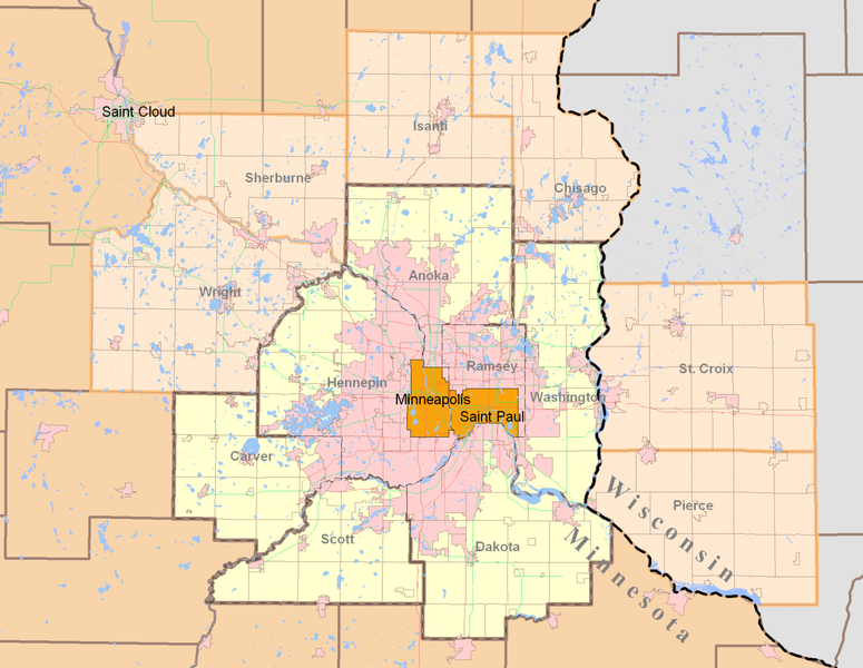
| 解説 | Minneapolis-Saint Paul (Twin Cities) highlighting both the 7-county Urban Area (traditional) and the revised 13-county Metropolitan Statistical Area from the 2000 Census. Today, the term Twin Cities typically refers to the metropolitan area. The pink areas represent urbanized areas as defined by the Metropolitan Council (urbanized meaning developed with sewer access and includes suburbia and small towns). The red and green lines are highways while the grid-like lines within the counties are township boundaries and mostly rural. Suburban cities are also defined within the pink area however they are not as apparent since their borders so regularly match up with existing highways and natural features. |
| 日付 | |
| 原典 | Own work by uploader using publicly and freely available cartographic data by state and private agencies. Raster by MapInfo, purchased for personal use and distributed for no monetary gain. |
| 作者 | Davumaya |
| 許可 (ファイルの再利用) |
Agencies providing this data and myself make no assertion that this data is an accurate representation or legally defined. It is provided as a fair representation and should not be used for legal purposes. |
ライセンス
この作品の著作権者である私は、この作品を以下のライセンスで提供します。
このファイルはクリエイティブ・コモンズ 表示-継承 3.0 非移植ライセンスのもとに利用を許諾されています。
- あなたは以下の条件に従う場合に限り、自由に
- 共有 – 本作品を複製、頒布、展示、実演できます。
- 再構成 – 二次的著作物を作成できます。
- あなたの従うべき条件は以下の通りです。
- 表示 – あなたは適切なクレジットを表示し、ライセンスへのリンクを提供し、変更があったらその旨を示さなければなりません。これらは合理的であればどのような方法で行っても構いませんが、許諾者があなたやあなたの利用行為を支持していると示唆するような方法は除きます。
- 継承 – もしあなたがこの作品をリミックスしたり、改変したり、加工した場合には、あなたはあなたの貢献部分を元の作品とこれと同一または互換性があるライセンスの下に頒布しなければなりません。
ファイルの履歴
過去の版のファイルを表示するには、その版の日時をクリックしてください。
| 日付と時刻 | サムネイル | 寸法 | 利用者 | コメント | |
|---|---|---|---|---|---|
| 現在の版 | 2008年8月12日 (火) 21:27 | | 1,500 × 1,161 (866キロバイト) | Davumaya | {{Information |Description= |Source= |Date= |Author= |Permission= |other_versions= }} <!--{{ImageUpload|basic}}--> |
| 2008年8月12日 (火) 21:22 |  | 2,000 × 1,545 (238キロバイト) | Davumaya | {{Information |Description=Minneapolis-Saint Paul (Twin Cities) highlighting both the 7-county Urban Area (traditional) and the revised 13-county Metropolitan Statistical Area from the 2000 Census. |Source=Own work by uploader using publicly and freely a |
ファイルの使用状況
以下のページがこのファイルを使用しています:
グローバルなファイル使用状況
以下に挙げる他のウィキがこの画像を使っています:
- de.wikipedia.org での使用状況
- en.wikipedia.org での使用状況
- fi.wikipedia.org での使用状況
- nl.wikipedia.org での使用状況
- pl.wikipedia.org での使用状況
- ro.wikipedia.org での使用状況
- simple.wikipedia.org での使用状況
- sv.wikipedia.org での使用状況
- vi.wikipedia.org での使用状況
.png)